Tag Archives: Roy Zimmer

Aerial photographs of Phosphate Mine site: WWALS to Union BOCC 2017-09-18

Sent today (as PDF) before this afternoon’s 4:30 PM Union County BOCC meeting at Union County High School.

September 18, 2017

To: James Tallman, Chairman
Union County Board of County Commissioners
15 NE 1st Street, Lake Butler, FL 32054
(386) 496-4241
ucbocc@windstream.net

Cc: Scott R. Koons, Executive Director
North Central Florida Regional Planning Council
2009 NW 67th Pl, Gainesville, FL 32653
(352) 955-2200
koons@ncfrpc.org

Re: Aerial photographs of Phosphate Mine site

Dear Chairman Tallman, Commissioners, Staff, Director Koons, and NCFRPC,

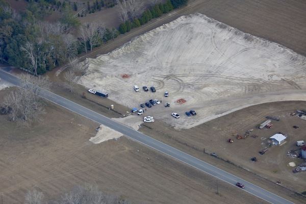
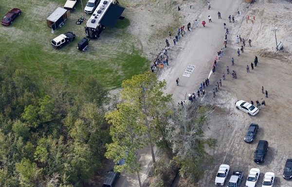
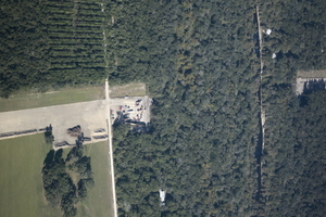
Sometimes it helps to see the problem from a different point of view, so on September 1st Suwannee Riverkeeper organized an overflight of the proposed HPS II mine site. Here are a few aerials from that flight. I hope they help encourage you to rezone to prevent mining in Union County, regardless whether from the current proposals or from others.

In addition to the few examples below, a few hundred more pictures are online here:

http://www.l-a-k-e.org/issues/phosphate/2017-09-01–southwings-phosphate/

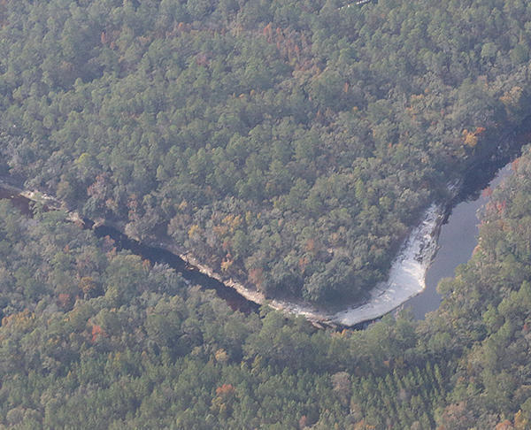
The Howard mine site at the corner of CR 231 and the New River includes Five Mile Creek and other wetlands. Between there and the Pritchett mine site many people own land that could be affected. Just beyond is Worthington Springs, downhill and thus downstream from the mine.

W across Howard mine site, Five Mile Creek, SW 48th Path, CR 18A, Pritchett mine site, Worthington Springs
W across Howard mine site, Five Mile Creek, SW 48th Path, CR 18A, Pritchett mine site, Worthington Springs, 09:53:54, 29.9461300, -82.3565700

From the air, Union county looks Continue reading

WWALS over Phosphate mine site, Union and Bradford Counties, FL 2019 2017-09-01

See from the air the land the Union County, Florida, Commissioners will be voting on tomorrow.

When: 4:30-9PM, Monday, September 17, 2017

Where: Union County High School, 1000 S. Lake Avenue, Lake Butler, FL 32054

What: Voting on Union County Comprehensive Plan with much stronger restrictions on mining

Event: Two facebook events, by Citizens Against Phosphate Mining in North Central Florida (CAPM)
and by Our Santa Fe River (OSFR).

WNW from Compressor Station up FGT pipeline to Columbia Co., 10:18:14,
WNW from Compressor Station up FGT pipeline to Columbia Co., 10:18:14, 29.9114200, -82.3324080

I took these pictures in Union and Bradford Counties, Florida, of the proposed HPS II phosphate mine site, on a Southwings flight for WWALS Watershed Coalition 1 September 2017. You can help figure out what some of them show.

The main conclusion, already published in much briefer form by Jim Tatum with a few pictures he took, is that Continue reading

Aerials: Woods Ferry Tract to Suwannee Springs 2016-11-23

These aerial photographs by Beth Gammie cover the route of the Saturady 20 May 2017 WWALS Outing down the Suwannee River from Woods Ferry Tract Launch to Suwannee Springs. She took them for WWALS 23 November 2016, on a Southwings flight piloted by Roy Zimmer. They’re all looking from Hamilton County south (or west) across the Suwannee River into Suwannee County.

Woods Ferry Tract Launch

Woods Ferry Tract Launch

I have pulled out a few detail shots, of Woods Ferry Tract Launch and of Suwannee Springs.

Suwannee Springs bathhouse

Continue reading

Hunters Creek Pipeline, Sabal Trail, Osceola County, FL 2017-02-07

The south end of Sabal Trail connects its Hunters Creek Pipeline, running through many wetlands and past many subdivisions and malls through Davenport and Kissimmee to connect to Florida Gas Transmission (FGT) just west of Florida’s Turnpike. This is all about six miles south and east of Disney World.

NW past Central Florida Pipeline Corp. to Reunion Compressor Station, 6781 Osceola Polk Line Rd, Davenport, FL 33896,
NW past Central Florida Pipeline Corp. to Reunion Compressor Station, 6781 Osceola Polk Line Rd, Davenport, FL 33896, 28.2610489, -81.5572004

Here are aerials taken Continue reading

Concrete around Sabal Trail pipe on Sand Mine Road 2017-02-07, 2017-02-21

Concreted pipe on Sand Mine Road at Greenbay Road 28.3110870, -81.6904770 In what document did FERC permit concrete wrapped around Sabal Trail pipe?

Concreted pipe detail 28.3100000, -81.6808333 And why was concreted pipe still being trucked in yesterday, two weeks after these aerials?

Pictures by Jim Tatum from Southwings flight for WWALS 7 Feb 2017

Sabal Trail down Sand Mine Road 28.3105110, -81.6738150

Continue reading

Aerials: Sabal Trail half mile from Dunnellon High School

Sabal Trail runs half a mile from Dunnellon High School and Elementary School, and even closer to a golf club to the north. In 2009 Florida Gas Transmission (FGT) blew up a much smaller 18-inch pipeline, flying a 104-foot piece of 18-inch pipe through the air, shutting down both I-95 and the Florida Turnpike, and fortunately missing a high school. You can help stop this $3.2 billion boondoggle and get on with solar power now for the Sunshine State.

Dunnellon High School and Sabal Trail half a mile away

And to the north, it’s even closer to Julliette Falls Golf Club and Community. Continue reading

Sabal Trail red pipe going into the ground in Hamilton County, FL 2017-01-14

Sabal Trail pipe going into the ground, 30.3841030, -83.1753430 The day of action against Sabal Trail at the Suwannee River saw hundreds turn out on land, water, and in the air and got a lot of press, but Sabal Trail continued to pound pipe into the ground in Hamilton County, Florida, going under Suwannee River State Park (SRSP) and the Suwannee River.

On the WWALS website are photographs by Beth Gammie for WWALS from a Southwings flight piloted by Roy Zimmer, navigated by Can Denizman, January 14, 2017. You may reuse these pictures provided you cite the source: Beth Gammie for WWALS Watershed Coalition.

For where they were taken, see the WWALS Google Map.

Lynn Buchanan posted a facebook video taken from the woods of Suwannee River State Park.

Panorama, Sabal Trail pipe going into ground, Hamilton County, 30.4113889, -83.1652778

Continue reading

CR 141 Sabal Trail Troy Access, Hamilton County, FL 2017-01-14

Are those two sinkholes at Sabal Trail’s Troy Access off CR 141 in Hamilton County, Florida, on the way to to under the Suwannee River? Only three Hamilton County Sheriff’s deputies was light law enforcement by Saturday’s protest day standards. What about those other sinkholes just outside the pipeline easement?

NE to CR 141 Sabal Trail entrance with 3 Hamilton Co. Sheriff, 30.4164450, -83.1765850

NE to CR 141 Sabal Trail entrance with 3 Hamilton Co. Sheriff,

SE to CR 141 Sabal Trail Troy Access, 30.4171760, -83.1768130

Continue reading

Revoke Sabal Trail Permits 2017-01-14

Water protectors encircle a sign saying “REVOKE SABAL TRAIL PERMITS” on 24th Street on Sabal Trail’s right of way leading to its Suwannee County horizontal directional drilling (HDD) site drilling under the Suwannee River and Suwannnee River State Park. So say we all.

24th Street at Sabal Trail RoW, 12:57 PM,

Photograph taken 12:57 PM, January 14, 2017 by Beth Gammie for WWALS from Southwings flight piloted by Roy Zimmer, navigated by Can Denizman. You may reuse this picture provided you cite the source: Beth Gammie for WWALS Watershed Coalition.

 -jsq, John S. Quarterman, Suwannee RIVERKEEPER®

You can join this fun and work by becoming a WWALS member today!

US 129 HDD Santa Fe River Sabal Trail 2016-10-22

South to North HDD, 29.9122530, -82.8515280 Sabal Trail plans to start drilling here in the next few days. I count three houses within the blast radius just in this picture at the Santa Fe River just east of US 129 in Suwannee and Gilchrist Counties, Florida. See also Jim Tatum’s pictures of this Santa Fe River Sabal Trail HDD location from this flight. Continue reading