
0.03 acres under the Withlacoochee River sold by the State of Georgia to Sabal Trail, operated by Spectra Energy of Houston, Texas, for $5,000, or $166666.66/acre.
 That easement must be very valuable to Sabal Trail.
But it’s more valuable to us who live here and swim, fish, and boat on that river
and drink from the Floridan Aquifer.
If we’d known this was going on, some of us might have filed other documents in this case.
That easement must be very valuable to Sabal Trail.
But it’s more valuable to us who live here and swim, fish, and boat on that river
and drink from the Floridan Aquifer.
If we’d known this was going on, some of us might have filed other documents in this case.
Also, I would have thought 666 once would have been enough.
Here are some things you can do to help stop this boondoggle, and background about why this pipeline is a bad idea when there are already more solar jobs than in oil and gas extraction, and Georgia is the fastest-growing U.S. solar market.
Here’s the judge’s final order (PDF), followed by the other court documents in this case:
LOWNDES COUNTY GEORGIA
FILED IN OFFICE
2016 JUL 29 PM 2:20
[signed] Beth C. Greene
CLERK OF SUPERIOR STATE
JUVENILE COURTS
CIVIL ACTION FILE NO. 2016CV1258IN THE SUPERIOR COURT OF LOWNDES COUNTY
STATE OF GEORGIASABAL TRAIL TRANSMISSION LLC,
Petitioner,v.
0.03 ACRES OF LAND, MORE OR LESS,
IN BROOKS COUNTY AND LOWNDES
COUNTY, GEORGIA,and
STATE OF GEORGIA,
and
DEPARTMENT OF NATURAL
RESOURCES,on behalf of the STATE OF GEORGIA,
and
STATE PROPERTIES COMMISSION,
on behalf of the STATE OF GEORGIA,Respondents.
FINAL JUDGMENT AND DECREE OF CONDEMNATION IN REM
On July 25, 2016, Sabal Trail Transmission, LLC (“Sabal Trail”) filed a Petition to condemn easement interests for the construction, operation and maintenance of an interstate natural gas pipeline over, through, and across lands, specifically the Withlacoochee River, owned solely by the State of Georgia and in which the Department of Natural Resources and the State Properties Commission, both on behalf of the State of Georgia (together with the State of Georgia, the “Respondents”) may have an interest. The Petition was accompanied by an Affidavit of the Respondents, by counsel and pursuant to O.C.G.A. §22-2-l32(a) (the “Affidavit”), verifying that the Respondents, as condemnees, do not oppose the condemnation. Following service of the Petition on Respondents on July 26, 2016, the Parties filed a Stipulation on July 27, 2016.
This matter is now before the Court on Sabal Trail’s Unopposed Motion for Entry of Final Judgment and Decree of Condemnation In Rem (the “Motion”), endorsed by counsel for Respondents as “unopposed.” After review of the record in this case, including the Affidavit and Stipulation, the Court finds and concludes as follows:
This Court has jurisdiction over the subject matter and the parties to this eminent domain action under the Natural Gas Act, 15 U.S.C. § 717f(h), and O.C.G.A. § 22-2-130 et seq., as well as in rem jurisdiction over the property at issue.
- The State has acknowledged service.
- Any procedural prerequisites to the filing of this action, including any statutorily required notice and rights under O.C.G.A. § 22-1-10, have been satisfied by Sabal Trail.
- Sabal Trail holds a Certificate of Public Convenience and Necessity to construct, operate and maintain an interstate natural gas pipeline and related facilities known as the Sabal Trail Project (“the Project”), pursuant to an Order Issuing Certificates and Approving Abandonment entered by the Federal Energy Regulatory Commission on February 2, 2016 (“FERC Certificate”).
- Pursuant to the FERC Certificate, Sabal Trail is properly exercising its Congressionally delegated federal power of eminent domain.
- Sabal Trail has the authority to condemn easements over public property pursuant to Section 7 of the federal Natural Gas Act, 15 U.S.C. § 717f(h).
- ln issuing the FERC Certificate and approving the alignment of the Project across the State property at issue in this case, FERC has concluded that the property is necessary for the Project.
- Sabal Trail has been unable to acquire the easement by contract with or grant from the State of Georgia, the sole owner of the subject property in issue in this case. 9, The Environmental Protection Division of the Georgia Department of Natural Resources certified that construction and operation of the Project will not violate State water quality standards, in accordance with Section 401 of the federal Clean Water Act, 33 U.S.C. § 1341(a)(1) on June 28,2016.
- Respondents acknowledge that just and adequate compensation for the proposed taking is the sum of $5,000 to be paid by Sabal Trail, and that amount has been deposited into the court registry.
Having determined that Sabal Trail has the right to condemn an easement on the property in issue, pursuant to the Natural Gas Act, 15 U.S.C. § 7l7f(h), which right may be exercised in state court, and that just compensation has been stipulated, the Court GRANTS the Motion and hereby ORDERS and DECREES the following as the JUDGMENT, in rem, of this Court:
- Sabal Trail is indefeasibly vested with legal title to the permanent easement sought in this action, the location and description of which easement and associated rights are described and shown in Paragraph 4 of the Petition and the Plat and Easement Terms attached as Exhibits 1 and 2, respectively, to the Petition, incorporated herein by reference.
- Sabal Trail may record this Final Judgment and the Petition, including Exhibits 1 and 2 attached thereto, among the land records of Lowndes County and Brooks County, Georgia, to be indexed in the name of Sabal Trail Transmission, LLC as Grantee, and the Respondents as Grantors.
Just compensation for the easement in the amount of $5,000, which has been paid into the Court’s registry, is awarded and shall be released by the Clerk of Court to the State Properties Commission.
IT IS SO ORDERED, this 29th day of 2016.
[signed, Jim Tunison?]
Judge, Superior Court of Lowndes County
Prepared and presented by:
![Prepared and presented by [attorneys for Sabal Trail]](/wp-content/themes/pianoblack/img//2016/08/2f26cbf25af575ca7f9b29dbba60dc52.jpg)
Matthew J. Calvert
Georgia Bar No 105340
mcalvert@hunton.com
Brooke F. Voelzke
Georgia Bar No. 728727
bvoelzke@hunton.com
Andrew S. Koelz
Georgia Bar No. 208399
akoelz@hunton.com
HUNTON & WILLIAMS LLP
Bank of America Plaza, Suite 4100
600 Peachtree Street, NE
Atlanta, Georgia 30308-2216James Thagard
Georgia Bar No. 703113
jamesthagard@youngthagard.com
Young, Thagard, Hoffman, Smith
Lawrence & Shenton, LLP.
801 Northwood Park Drive
Valdosta, GA 31604
Counsel for Plaintiff
Sabal Trail Transmission, LLC
Pieces of Sabal Trail’s Petition (PDF) referenced in the Final Order
THE PARTIES
Petitioner Sabal Trail is a Delaware limited liability company authorized to do business in the State of Georgia, with its principal place of business at 5400 Westheimer Court, Houston, Texas 77056-5310.
- Sabal Trail is an interstate natural gas pipeline company under the Natural Gas Act, 15 U.S.C. §§ 717 et seq.
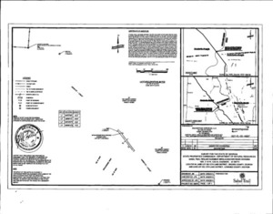
- The real property over which easement interests are sought to be condemned is located in Brooks County and Lowndes County, Georgia and lies beneath the Withlacoochee River (the “Property”). The location and description of the easements and associated rights sought to be condemned are described and shown in the Plat attached as Exhibit 1, and the Easement Terms attached as Exhibit 2, incorporated by reference.
The Property is identified and described as follows:
All that tract or parcel of land 10 feet in width lying and being part of Land Lot 203, of the 12th Land District of Brooks County, Georgia and Land Lot 203, of the 12th Land District of Lowndes County, Georgia being more particularly described as follows:
COMMENCING at a concrete monument marking a corner of a parcel now or formerly owned by The Langdale Company, thence across said tract, South 35 degrees 50 minutes 13 seconds East, a distance of 7,259.21 feet to the toe of the Northwest bank of the Withlacoochee River and the POINT OF BEGINNING, having a Georgia West Zone NAD 83 State Plane, US. survey feet, coordinate of Northing: 290,015.24 feet and Easting: 2,520,686.51 feet Thence from said POINT OF BEGINNING, along said toe of the Northwest bank, North 43 degrees 01 minutes 59 seconds East, a distance of 10.12 feet; thence crossing the Withlacoochee River, South 38 degrees 09 minutes 14 seconds East, a distance of 149.81 feet to a the toe of the Southeast bank of the Witltlacoochee River; thence along said toe of the Southeast bank, South 46 degrees 43 minutes 02 seconds West, a distance of 10.04 feet to a point; thence crossing the Withlacoochee River, North 38 degrees 09 minutes 14 seconds West, a distance 11.54 feet to the toe of the Northwest bank of the Withlacoochee River and the POINT OF BEGINNING.
Said tract containing 1495 square feet or 0.03 acres.
Exhibit 1
Map: Location

Map: Topography

Exhibit 2
EASEMENT TERMS
The interest to be acquired by Sabal Trail Transmission, LLC (“Sabal Trail”) ( in the lands described in the Petition at Paragraphs 3 & 4 and Exhibit 1 thereto (the “Property”), and the use therefore is a permanent right-of-way and easement (“Right-of-Way”) for the purposes, presently and at any such time in the future as Sabal Trail may elect and the Federal Energy Regulatory Commission may authorize, of constructing, laying, maintaining, operating, inspecting, altering, repairing, replacing, removing, reconstructing and abandoning a pipeline, from time to time, and any and all necessary appurtenances thereto, (“Pipeline Facilities”), all of which shall be and remain the property of Sabal Trail for the transportation of natural gas, through the lands described in the Complaint at Paragraphs 3 & 4 and Exhibit 1.
The Right—of-Way shall be a total width often feet (10′) as shown on the Plat attached to the Petition as Exhibit 1.
The Right-of-Way shall include, and Sabal Trail shall have, all other rights and benefits necessary to accomplish the aforesaid purpose, including but not limited to the right of ingress and egress.
The Pipeline Facilities constructed pursuant to this Grant of Easement shall be installed by the Horizontal Directional Drill method. The Pipeline Facilities shall be installed in such a manner as to prevent the occurrence of any floating, rising, or uncovering of the Pipeline Facilities.
Sabal Trail shall in no way forbid or interfere with the full and free use by the public of the waters above the Pipeline Facilities for navigation, sport, fishing, recreation, or pleasure.
Here’s PDF of the Georgia Attorney General’s office saying they wouldn’t defend the citizens, land, water, or safety of Georgia against this invader from Houston, Texas.
And here are PDFs of the rest of the case documents received from the Lowndes Superior Court: Set-2-E00kdj1.003.pdf, Set-3-E00kdkr.003.pdf, Sabal Trail’s Final Motion. Many thanks to DeDe Wheeler of the Clerk of Court’s office for speedy handling of these documents.
-jsq
You can join this fun and work by becoming a WWALS member today!
Short Link:
Pingback: Sabal Trail is Getting Permitted To drill under Georgia Rivers | SpectraBusters
Pingback: FERC Authorization for Sabal Trail to Commence Drilling under Georgia Rivers 2016-08-25 | WWALS Watershed Coalition