
Commissioners from counties on both sides of the Suwannee River saw the sinkholes and big oaks and pines directly above and near where
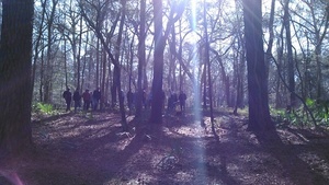 Sabal Trail proposes to bore under Suwannee River State Park and the River,
led by WWALS board member and Hamilton County resident Chris Mericle,
assisted by Debra Johnson of SpectraBusters, Merrillee Malwitz-Jipson of Our Santa Fe River (OSFR), and others from as far away as south Florida.
All but one of the Suwannee County Commissioners were there, and he had a good excuse.
They also saw Falmouth Spring, which is part of a cave system which Sabal Trail claims is 100 feet deep. Both county commissions meet Tuesday March 1st; see below for details.
WWALS videos
Sabal Trail proposes to bore under Suwannee River State Park and the River,
led by WWALS board member and Hamilton County resident Chris Mericle,
assisted by Debra Johnson of SpectraBusters, Merrillee Malwitz-Jipson of Our Santa Fe River (OSFR), and others from as far away as south Florida.
All but one of the Suwannee County Commissioners were there, and he had a good excuse.
They also saw Falmouth Spring, which is part of a cave system which Sabal Trail claims is 100 feet deep. Both county commissions meet Tuesday March 1st; see below for details.
WWALS videos to come now posted.
You can see Continue reading
Tag Archives: Chris Mericle
Pictures: Withlacoochee and Suwannee Rivers, WWALS Outing, 2014-09-21
Gretchen Quarterman took these pictures on the
Withlacoochee and Suwannee paddle: springs, shoals, and pipeline 21 Sept 2014.
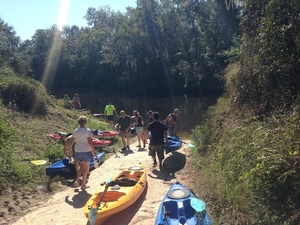 This was a long outing Chris Mericle organized down two rivers with many people, past springs, shoald, and sinkholes,
and past the crossings formerly proposed by Spectra Energy for its Sabal “Sinkhole” Trail fracked methane pipeline before it moved upstream on the Suwannee,
as seen
2015-08-15 and
2015-11-15.
It was also before we started the
Withlacoochee and Little River Water Trail.
Click on any small picture below to see a larger one.
This was a long outing Chris Mericle organized down two rivers with many people, past springs, shoald, and sinkholes,
and past the crossings formerly proposed by Spectra Energy for its Sabal “Sinkhole” Trail fracked methane pipeline before it moved upstream on the Suwannee,
as seen
2015-08-15 and
2015-11-15.
It was also before we started the
Withlacoochee and Little River Water Trail.
Click on any small picture below to see a larger one.
-jsq
You can join this fun and work by becoming a WWALS member today!
Continue readingWithlacoochee River
 A gorgeous day on the Withlacoochee River.
Chris Mericle
A gorgeous day on the Withlacoochee River.
Chris Mericle Jumping Gully Creek
 The confluence of Jumping Gully Creek with the Withlacoochee River.
Chris Mericle
The confluence of Jumping Gully Creek with the Withlacoochee River.
Chris Mericle Withlacoochee River
 A true survivor, a lone cypress tree in the middle of the Withlacoochee River.
Chris Mericle
A true survivor, a lone cypress tree in the middle of the Withlacoochee River.
Chris Mericle Withlacoochee and Little River Confluence
 The flow from the Little River seemed to be much greater than the flow from the Withlacoochee River. Not very impressive at this water level.
Chris Mericle
The flow from the Little River seemed to be much greater than the flow from the Withlacoochee River. Not very impressive at this water level.
Chris Mericle Little River
 A frosty morning on the Little River just downstream of Reed Bingham State park.
 Hotchkiss Road to Mayday, Alapaha River 2016-04-23
See the beautiful blackwater Alapaha River while it’s high,
in the middle of the Alapaha River Water Trail,
from Hotchkiss Road in Lanier County to Mayday in Echols County.

When: 8AM Saturday 23 April 2016
Put in: Hotchkiss Road in Lanier County, 30.93669, -83.0406
Take out: Mayday in Echols County, 30.82827, -83.017179
Distance: 12.7 miles
Duration: about 6 hours
Directions: Continue reading
Roosters outfitter
 Roosters Outfitters along Swift Creek near White Springs, FL Camping, hunting, fishing, and hiking gear.
 Swift Creek confluence with Suwannee River
Chris Mericle took this picture today, 20 December 2015,
 of Swift Creek entering the Suwannee River,
just east of I-75, in the Swift Creek Conservation Area,
in Hamilton County, Florida,
at
30.3460222, -82.8268667.
-jsq
of Swift Creek entering the Suwannee River,
just east of I-75, in the Swift Creek Conservation Area,
in Hamilton County, Florida,
at
30.3460222, -82.8268667.
-jsq
