Tag Archives: Clinch County

Walter Parks, Swamp by Chandelier

You won’t hear this every day. Thanks to Flint Riverkeeper Gordon Rogers for pointing to these Okefenokee Swamp hollers by Walter Parks.

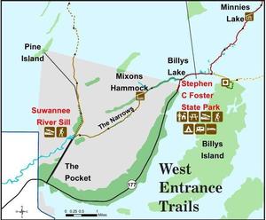
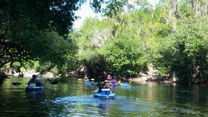
And don’t forget WWALS has an outing 10AM this Saturday December 10th at Georgia’s Stephen C. Foster State Park on the Suwannee River near Fargo, GA, to paddle into the Okefenokee Swamp. Continue reading

Okefenokee Suwannee River Outing @ Fargo, GA 2016-12-10

Update 2017-02-05 Pictures.

Okefenokee West Entrance Trails You can join WWALS for a fall Saturday paddle on the Suwannee River in the Okefenokee swamp. Bring a boat, PFD, and paddle, or you can rent those at the park.

When: 10AM Saturday December 10th 2016

Where: Georgia’s Stephen C. Foster State Park near Fargo, GA

What: Paddle from Billy’s Lake down through the River Narrows to the Suwannee River Sill.

Distance: About 7 miles in about 4 hours Continue reading

Redoux Suwannee River Roline to Cypress Creek, 2016-09-03

Update 2016-09-04: “We’re on for Monday morning! River excellent condition,” says expedition leader Phil Hubbard.

Update 2016-09-02: Delayed until 10AM Monday 5th September due to aftereffects of Hurricane Hermine.

Update 2016-09-01: Watching Tropical Storm Hermine.

More people want to go after the pictures and reports from a few weeks ago, so WWALS has scheduled a redo from Roline to Cypress Creek on the iconic Suwannee River in north Florida. Also with a slightly later start this time; more convenient for far-away folks.

When: 10AM Saturday September 3rd 2016

Put in: Roline Launch, 30°33’51.0″N 82°43’30.6″W or 30.564185, -82.725167

Duration: 7.5 miles, about 4 hours.

Events: facebook, meetup.

Directions: Continue reading

Roline to Cypress Creek, Suwannee River, 2016-08-13

Join us for a summer morning paddle on the iconic Suwannee River in Florida.

Shuttle When: 8AM Saturday August 13th 2016

Put in: Roline Launch, 30°33’51.0″N 82°43’30.6″W or 30.564185, -82.725167

Directions: From Jasper: east on CR 6 approx. 15 miles, left on Woodpecker Rd. (Dirt) about 3 miles, follow sign to launch.

Take out: Cypress Creek South Launch

Duration: 7.5 miles, about 4 hours.

Events: facebook, meetup.

Shuttle: Continue reading

Two GA-EPD water advisories about US 84 widening project

Thirty-day comment periods closing 12 August 2015 to comment on the US 84 widening project, say 300x175 Greasy Branch, CSX Railroad, Upper Suwannee River Watershed, in Two GA-EPD water advisories about US 84 widening project, by John S. Quarterman, for WWALS.net, 13 July 2015 two Public Advisories from GA-EPD Watershed Protection Branch. One is in the Satilla River watershed, about “two existing open water ponds (outflowing into jusrisdictional[sic] wetlands associated with Lees Branch)”: those ponds are next to the groundwater-contaminating CSX railyard in Waycross. One is in the Upper Suwannee River watershed, about “three existing open water ponds (outflowing into jusrisdictional[sic] waters associated with Greasy Creek and the CSX railroad)”. Maybe the Southern Environmental Law Center letter to GDOT and the U.S. Army Corps of Engineers got some results, although these advisories are from a different state agency.

The Upper Suwannee one starts at Continue reading

For development, or not needed? US 84 widening from Homerville to Waycross

This paragraph sums it up:

300x388 Wetlands 29 and 31, in RE: SAS-2014-00862, Proposed U.S. Highway 84 Widening, by Gilbert B. Rogers, for WWALS.net, 28 May 2015 The project’s stated purpose in the EA is “economic development,” as part of the Governor’s Road Improvement Program created in the 1980s. See EA at 4. The NEPA regulations promulgated by the Council on Environmental Quality (“CEQ”) require agencies to examine the indirect impacts of projects — those growth-inducing impacts caused by a project, such as changes in land use and development patterns. 40 C.F.R. § 1508.8(b). Yet over and over, when purporting to examine the project’s potential for indirect impacts on various natural resources, the EA repeats, “The proposed project is not expected to precipitate substantial development along the corridor.”

Other questions include, why not use a narrower median? Why not leave trees on the median?

Below is the full text of the letter Continue reading

Widening US 84 from Homerville to Waycross

300x232 Figure 4.1: State and Federal Waters Map, in US 84 four-laning from Homerville to Waycross, by John S. Quarterman, for WWALS.net, 28 April 2015 GDOT and the Army Corps want to widen U.S. 84 from Homerville to Waycross. Since it appears that US 84 is already four lane from Thomasville through Quitman and Valdosta to Homerville, and from Waycross onwards northeast, this would be the remaining gap. The public notice says little or nothing about why this road work might be needed.

U.S. Army Corps of Engineers, Public Notice, 28 April 2015, SAS-2014-00862 (SP-WMR), Widening and Reconstruction of U.S. Highway 84, with PDF. Since that notice says it expires in a month, there’s also a copy of the PDF on the WWALS website, including this location information: Continue reading