Tag Archives: Georgia Open Records Act

Valdosta Sewage Spill Reports: Jackson Drive, not Street, and Sugar Creek 2025-02-17

Update 2025-02-22: Ashburn Spill 2025-02-14, Chemours Mine Spill 2025-02-16, Bad Little River 2025-02-17, Bad Withlacoochee River 2025-02-19 2025-02-19.

Valdosta reported the January 14, 2025, sewage spill in the wrong place. It was actually on Jackson Drive, near the Lowndes County Jail, not on Jackson Street, in downtown Valdosta.

[Jackson Drive, not Street, Dukes Bay Canal, Valdosta, GA Sewage Spills, and Sugar Creek]
Jackson Drive, not Street, Dukes Bay Canal, Valdosta, GA Sewage Spills, and Sugar Creek

Thanks to a tip, I asked Valdosta Utilities Director Jason Barnes, who told me they reported the correct GPS coordinates. But GA-EPD does not publish GPS coordinates.

So WWALS sent an open records request asking for, “All sewage spill reports sent from the City of Valdosta to the Georgia Environmental Protection Division (GA-EPD) from December 4, 2024, through February 17, 2025, as well as any and all related correspondence between the City and GA-EPD.”

As usual, we got no correspondence, but we did get the report, which erroneously says Jackson Street, but it does have the GPS coordinates: 30.81102673, -83.27182962. Continue reading

Valdosta sewage spill reports to GA-EPD from November 7 through December 3, 2024

Update 2024-12-13: Filthy Sugar Creek, dirty Franks Creek, bad upstream Withlacoochee River, clean downstream 2024-12-12.

I got part of what I asked for in an open records request to the City of Valdosta: “All sewage spill reports sent to the Georgia Environmental Protection Division (GA-EPD) on or after November 6, 2024, through December 2, 2024”. Those provide some extra detail, and some hints of fixes being planed for these problems.

[Valdosta sewage spill reports to GA-EPD, from November 7 through December 3, 2024]
Valdosta sewage spill reports to GA-EPD, from November 7 through December 3, 2024

I did not get the rest of it: “together with all associated correspondence between the City of Valdosta, GA-EPD, and other parties including state agencies in Georgia and Florida and relevant landowners.”

The December Meadowbrook Drive spill into Two Mile Branch

Let’s look at the most recent spill in the GA-EPD Sewage Spills Report, and compare that to what Valdosta Utilities sent to GA-EPD. Continue reading

GA-EPD: Twin Pines massive submittals short on analysis, incomplete, not sufficient, and wetland impacts not temporary 2019-12-05

“We reiterate our concern and position that an appropriate project review for 401 water quality certification is not yet possible since complete substantive and important information about the proposed hydrogeologic effects of this project relative to the surrounding landscape has not yet been submitted by the applicant. …So substantial, so massive, so transformative is the effect to wetlands contemplated at the Twin Pines site that you no longer have in place the original wetland to be impacted.” The Georgia Environmental Protection Division (GA-EPD) wrote that to the U.S. Army Corps of Engineers (USACE) in response to the thousands of pages of low-level data but only a few pages of analysis that Twin Pines Minerals (TPM) has sent those agencies.

Twin Pines Minerals is still failing to hoist its burden of proof that its propsosed titanium strip mine would not jeopardize this national treasure, the Okefenokee Swamp, the headwaters of the Suwannee and St. Marys Rivers.

[Tribal Grounds west along GA 94 to TPM equipment, 12:38:38, 30.5257540, -82.0411100]
Photo: John S. Quarterman for WWALS, of Tribal Grounds west along GA 94 to TPM equipment, 12:38:38, 30.5257540, -82.0411100, on Southwings flight, pilot Allen Nodorft, 2019-10-05.
See also pictures from that flight by Wayne Morgan.

Maybe the City of Folkston and Charlton County Development Authority (CCDA) might want to rethink its assertion in the Charlton County Herald that “We would not support anything that would jeopardize this national treasure.” GA-EPD’s opinion is much like what U.S. EPA said, that the mine would have “substantial and unacceptable impact”.

CCDA wrote, Continue reading

Stream Monitoring after Lowndes County Val-Tech Road Spill 2017-09-23

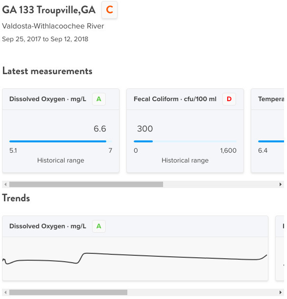
Here is Lowndes County’s (not Valdosta’s) stream monitoring data for a year after its September 23, 2017 raw sewage spill into a ditch that goes to the Withlacoochee River. The data show often worse water quality upstream than downstream. This is a good illustration of why WWALS is starting a water quality testing program.

Graphs, Below at GA 133

These graphs are in Water Reporter, where I put the data under the Suwannee Riverkeeper group. The first two graphs are from below the spill, downstream on the Withlacoochee River at GA 133 (St. Augustine Road).

Graphs, Below at GA 133

Fecal Coliform, Below at GA 133

The other graphs show nothing unusual for blackwater tannic acid rivers. This is the interesting graph, Continue reading