Tag Archives: precipitation

No spills yet from rain on Valdosta 2024-07-28

Update 2024-08-02: Three more Ashburn sewage spills reported more than a week late 2024-07-20.

Pictures of flooding in Valdosta are circulating on social media.

[Flooding in Valdosta, Three inches of rain 2024-07-28, No sewage spills yet. Other contaminants?]
Flooding in Valdosta, Three inches of rain 2024-07-28, No sewage spills yet. Other contaminants?

As usual, people are commenting that Valdosta must be spilling wastewater.

So I called Valdosta Utilities Director Jason Barnes. He says there have been no spills from this rain.

Sometimes WWALS members spot them first. So if you see or smell a spill, please let us know.
https://wwals.net/report/

The Valdosta Utilities Director didn’t mention, because he’s not in charge of this: there may be E. coli from other sources, such as pets, livestock, and wildlife.

And of course there will be trash washed into creeks and rivers, especially from all the parking lots that do not yet have trash cans. Much of that trash converges onto Sugar Creek, along with any sewage spills, because something like 80% of Valdosta drains into that creek.

I commend Anetra Riley and Valdosta City Marshalls for Continue reading

Better Saturday at Knights Ferry, Nankin, Withlacoochee River, but rain 2020-04-18

Update 2020-04-24: OK quality mid-week, but much rain yesterday, Withlacoochee River 2020-04-22.

WWALS Testing Committee Chair Suzy Hall got 300 cfu/100 mL E. coli at Knights Ferry Boat Ramp Saturday, and 333 at Nankin Boat Ramp, both on the Withlacoochee River. That’s similar to Thursday at Knights Ferry, and better at Nankin; both not good, but not terrible. See also What do these numbers mean?

But watch out: it rained a quarter inch in Brooks County, Georgia, Sunday. WWALS continues testing and correlating results from various sources with rainfall.

You can help by donating for water quality collection supplies. Even those metal yellow Caution signs cost money. See below for those signs going up during the livestreamed virtual Earth Day cleanup at Knights Ferry Boat Ramp.

[Boaters, Suzy, signs, trash, Bobby]
Boaters, Suzy, signs, trash, Bobby

There were a bunch of boaters, all keeping their distance. They were already aware of the contamination, but did not plan to get in the river water.

Apparently most of the previous contamination had washed down the river, but how far? Continue reading

GA-EPD: Twin Pines massive submittals short on analysis, incomplete, not sufficient, and wetland impacts not temporary 2019-12-05

“We reiterate our concern and position that an appropriate project review for 401 water quality certification is not yet possible since complete substantive and important information about the proposed hydrogeologic effects of this project relative to the surrounding landscape has not yet been submitted by the applicant. …So substantial, so massive, so transformative is the effect to wetlands contemplated at the Twin Pines site that you no longer have in place the original wetland to be impacted.” The Georgia Environmental Protection Division (GA-EPD) wrote that to the U.S. Army Corps of Engineers (USACE) in response to the thousands of pages of low-level data but only a few pages of analysis that Twin Pines Minerals (TPM) has sent those agencies.

Twin Pines Minerals is still failing to hoist its burden of proof that its propsosed titanium strip mine would not jeopardize this national treasure, the Okefenokee Swamp, the headwaters of the Suwannee and St. Marys Rivers.

[Tribal Grounds west along GA 94 to TPM equipment, 12:38:38, 30.5257540, -82.0411100]
Photo: John S. Quarterman for WWALS, of Tribal Grounds west along GA 94 to TPM equipment, 12:38:38, 30.5257540, -82.0411100, on Southwings flight, pilot Allen Nodorft, 2019-10-05.
See also pictures from that flight by Wayne Morgan.

Maybe the City of Folkston and Charlton County Development Authority (CCDA) might want to rethink its assertion in the Charlton County Herald that “We would not support anything that would jeopardize this national treasure.” GA-EPD’s opinion is much like what U.S. EPA said, that the mine would have “substantial and unacceptable impact”.

CCDA wrote, Continue reading

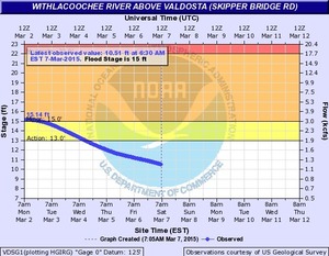
Spring Flood Potential Outlook for Withlacoochee River by NWS

There is potential for “a high impact basin-wide flood event this spring should heavier than normal rainfall occur” in the Withlacoochee Basin.

300x233 Vdsg1 Hg Skipper Bridge, in Withlacoochee River Gauges, by NWS, for WWALS.net, 7 March 2015 National Weather Service Tallahasee, FL 240 PM EST THU MAR 5 2015, Spring Flood Potential Outlook for Southeast Alabama, Southwest and South Central Georgia, and the Florida Panhandle and Big Bend,
Above normal potential for river flooding this Spring,
Existing Conditions.

In the Withlacoochee, Suwannee Basin…

Continue reading