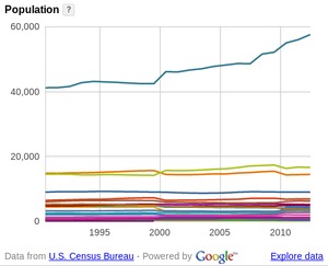
Can you remember all 23 counties in the WWALS watersheds,
and the thirty or more cities and towns?
I can’t, so I made a new WWALS web page on
WWALS Counties and Cities,
with population comparisons and maps.
Some of it may surprise you.
A strip of forest along a stream channel, also called a riparian forest buffer, has been proposed and used for decades as a best management practice to protect streams by filtering out contaminants from agriculture and other land uses before they can enter them.Their benefits are many, but one benefit has dominated social and political conversations, and that is their role in preventing contaminants from entering streams.
Maybe we need signs like that around here to remind
people that what goes into the ground comes out in our
drinking water.
For example,
San Antonio has its
Edwards Aquifer Protection Program.
Maybe our local governments need to have
Floridan Aquifer Protection Programs.
Georgia state law seems to indicate they should.
(1) Background. Variable levels of recharge area protection can be
based upon the State’s hydrogeology (e.g., areas such as the
Dougherty Plain where a major aquifer crops out would receive a
relatively high degree of protection whereas other areas, such as
the shale hills of northwest Georgia, would receive a lower degree
of protection). Recharge area protection within the significant
recharge areas would be further refined, based upon the local
susceptibility or vulnerability to human induced pollution (e.g.,
high, medium, or low). The significant recharge areas have already
been identified and mapped (about 22-23% of the State). Pollution
susceptibility mapping is ongoing. Existing statutes are adequate
for protecting the remaining recharge areas (about 77-78% of the
State).
[…]
(2)(f)3. In the Coastal Plain, the significant recharge areas are Continue reading →
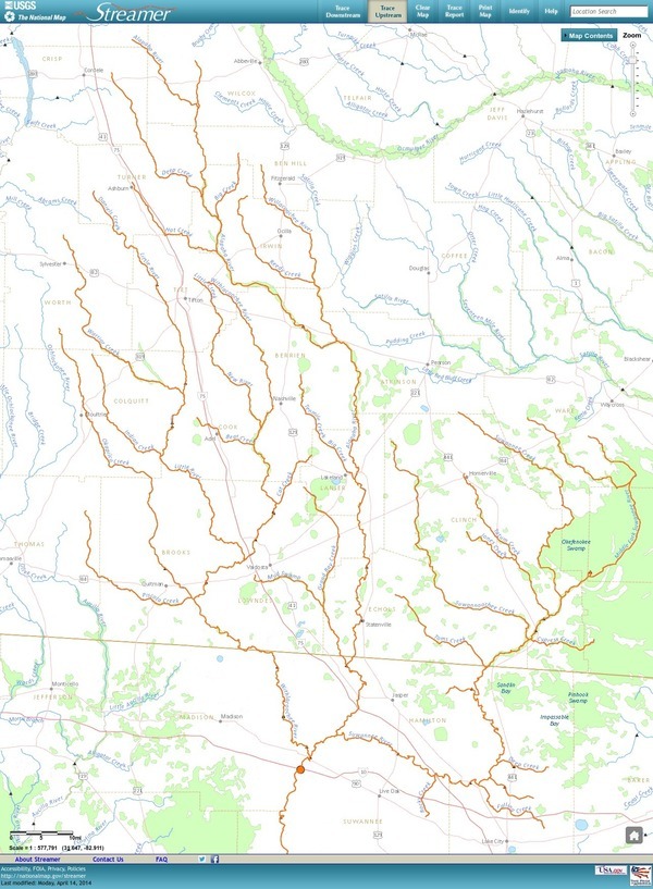
Update 3 March 2016: Suwannee River, ten rivers, and current location of USGS streamer.
The USGS Streamer interactive map
shows all (well, most) tributaries
of our two biggest WWALS rivers.
Visitors sometimes refer to our “four rivers”
since we only originally named four in our
WWALS mission:
Withlacoochee, Willacoochee, Alapaha, and Little.
Yet we added the upper Suwannee, and there always were more than that:
from one to ten rivers, depending on how you count them.
The Withlacoochee River tributary map here shows
the New River south of Tifton joining the Withlacoochee between
Nashville and Adel.
The New River is rather important, since it forms half of the boundary between Cook
and Berrien Counties (the Withlacoochee River forms the other half): Continue reading →
Water issues strongly affect economic development, so I talked about
the new WWALS Watershed Coalition at the
16 April 2013 Board Meeting
of the Valdosta-Lowndes County Industrial Authority.
The VDT declined to speak, so I did.
After apologizing for no okra today,
I commended the Authority for talking about the missing agenda items
and for mentioning due diligence and flood control.
WWALS board meetings are every second Wednesday of the month,
usually at the IHOP in Adel because it’s centrally located.
WWALS is communicating with Valdosta and
various organizations about
flooding and other watershed-wide issues, which in my opinion
have to do with things like too much clearcutting without
consideration for where the water goes, too much development
without consideration for what the impervious surface would do,
(to my surprise, the Executive Director and several board
members nodded along with that)
so it was good to hear them mention flood containment.
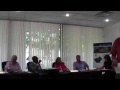
Arsenic, Outings, and Flooding: WWALS Watershed Coalition
Regular Meeting, Valdosta-Lowndes County Industrial Authority (VLCIA),
Norman Bennett, Tom Call, Roy Copeland, Chairman, Mary Gooding, Jerry Jennett,
Andrea Schruijer, Executive Director, J. Stephen Gupton, Attorney, Tom Davis, CPA, Allan Ricketts, Project Manager,S. Meghan Duke, Public Relations & Marketing Manager, Lu Williams, Operations Manager,
Video by John S. Quarterman for Lowndes Area Knowledge Exchange (LAKE), Valdosta, Lowndes County, Georgia, 16 April 2013.

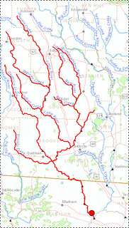
 The Alapaha River starts way up in Turner County,
and runs right through Nashville in Berrien County,
Lakeland in Lanier County, Statenville in Echols County,
and near Jasper in Hamilton County, Florida.
These counties and cities are the core of the
Alapaha River Water Trail.
Come see the middle of that Trail this afternoon:
Alapaha River @ US 84: endpoint of Sunday’s WWALS Outing 24 August 2014. Continue reading
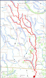
The Alapaha River starts way up in Turner County,
and runs right through Nashville in Berrien County,
Lakeland in Lanier County, Statenville in Echols County,
and near Jasper in Hamilton County, Florida.
These counties and cities are the core of the
Alapaha River Water Trail.
Come see the middle of that Trail this afternoon:
Alapaha River @ US 84: endpoint of Sunday’s WWALS Outing 24 August 2014. Continue reading 


