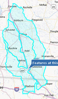
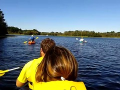
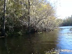
Tag Archives: Withlacoochee

Oil drilling in our aquifer?

There’s a bill in the Florida House to drill for oil in a state park in the same aquifer we drink out of.

A group is organizing through facebook and reddit and elsewhere to oppose this bill:

Save Blackwater River State Forest

An alliance of citizens committed to protecting the beautiful Blackwater River State Forest from proposed House Bill 431, that would allow oil and mining in the forest.
Continue reading

WWALS in the Tifton Gazette

The Tifton Gazette carried the WWALS press release on Page 8A, Tuesday, January 15, 1013:

Page 8A Picture, Tuesday, January 15, 2013

Continue reading

Veteran River Conservationist Gordon Rogers spoke to new WWALS Watershed Coalition

WWALS logo WWALS Watershed Coalition

FOR IMMEDIATE RELEASE

Veteran River Conservationist Gordon Rogers spoke to new WWALS Watershed Coalition

Adel, GA, 9 January 2013 — A local watershed group formed in June 2012, WWALS Watershed Coalition, invited Gordon Rogers, Flint Riverkeeper, to its first meeting of the new year to bring his experiences with the Altamaha, Satilla, and Flint Rivers to its conservation efforts on behalf of local blackwater rivers in south central Georgia.

Gordon Rogers speaks to WWALS board

Three newcomers, Garry Gentry, Dave Hetzel, Al Browning, Bret Wagenhorst, Gordon Rogers, Karan Rawlins, Gretchen Quarterman

Continue reading

Our WWALS Watersheds

Update 2016-03-03: Please see Streamer on the Suwannee, Withlacoochee, and Alapaha.

WWALS Watersheds Here in our WWALS watersheds in south central Georgia, instead of a single big river like the Flint or Altamaha, our many small blackwater streams meander through cypress swamps and remnants of longleaf pine forests. Tannin from oak roots produces the tea color that is one of many attractive features of our streams.

Maybe you, like me, have trouble keeping track of the watersheds of the Willacoochee, Withlacoochee, Alapaha and Little River Systems. U.S. EPA has much useful information about every U.S. watershed. On the right is a map I got EPA’s My WATERS Mapper to make by clicking on a point near Valdosta (a point just north of Tifton also works) that was close to all three WWALS watersheds known to that Graphical Information System (GIS):

Continue reading

WWALS at Reed Bingham State Park 2012-10-22

WWALS had a brief canoe and kayak outing at Reed Bingham State Park Sunday, led by Bret Wagenhorst. Heading out, and some coppices of native trees.

Heading out Coppices Continue reading

Big Little Water: Camera 1 Videos on the Withlacoochee by Tom Baird

Here are videos of Tom Baird’s talk for WWALS hosted at VSU by Blazer Gardens, about the Y-shaped Withlacoochee, or Suwannee, or Swithlacoochee, from the dry Paleo-Indian era 14,000 or more years ago through atlatls in the woodland period and Troupville queen city through the Ellaville log boom to current-day over-pumping of the aquifer.

Here’s a playlist.

Adopt-A-Stream water quality testing training with WWALS 2012-08-25

Students getting water from creek for Adopt-A-Stream water quality testing training.

Students getting water from creek for Adopt-A-Stream water quality testing training.

Angela Bray of the Southern Georgia Regional Commission (SGRC), assisted by Richard Battenn of SGRC and Al Browning, taught an Adopt-A-Stream water quality testing workshop Saturday 25 August 2012 in Valdosta.

Here’s a video playlist.

A few highlights:

Continue reading