Deanna Mericle posted on facebook 11 November 2014,
Chris and I hiked the riverbed of the Alapaha River and found the other sink!
Other as in different from the Dead River Sink. Continue reading

Deanna Mericle posted on facebook 11 November 2014,
Chris and I hiked the riverbed of the Alapaha River and found the other sink!
Other as in different from the Dead River Sink. Continue reading
The Alapaha River goes underground because the underlying karst limestone rises in what’s called the Cody Scarp, which runs across north Florida. Other rivers that go underground there include the Little Alapaha River and the Santa Fe River. The Withlacoochee River does not go underground, but it does sprout Madison Blue Spring.

Source: Bulletin of the Geological Society of America, vol. 123, no. 3-4, p. 457.
Here’s a cutaway diagram of how all that works underground: Continue reading
 Plants in our watersheds and along our waterways affect everything from
water flow to absorption to water quality to esthetics.
This Saturday there’s a conference about that near the Alapaha River.
Plants in our watersheds and along our waterways affect everything from
water flow to absorption to water quality to esthetics.
This Saturday there’s a conference about that near the Alapaha River.
Annual Meeting, Coastal Plain Chapter, Georgia Native Plant Society,
November 15, 2014 Continue reading
A county commission is representing its people and the waters of Georgia in a resolution Dougherty County sent to FERC which says in part:
Continue reading
SECTION II Thus, we are in opposition to the construction of the proposed pipeline in Dougherty County and request that FERC give serious consideration and analysis to alternative routes (1) that avoid unstable geologic areas such as karst and sink-hole prone areas, (2) that minimize impacts to drinking water and agricultural water supplies, (3) that minimize impacts to wildlife habitat, forest, wetlands, streams and rivers and (4) that do not compromise socio-economic and cultural issues.
 Not only is Valdosta
putting in a new force main to stop the manhole overflows in neighborhoods
near the Withlacoochee River,
it plans to abandon the current trunk main next to the river
once that project is finished.
An update on Valdosta’s sanitary sewer projects
by Tim Carroll led to
this map of the projects, on which you can see that rerouting: Continue reading
Not only is Valdosta
putting in a new force main to stop the manhole overflows in neighborhoods
near the Withlacoochee River,
it plans to abandon the current trunk main next to the river
once that project is finished.
An update on Valdosta’s sanitary sewer projects
by Tim Carroll led to
this map of the projects, on which you can see that rerouting: Continue reading
 WWALS will have a booth at the annual
Alapaha Celebration Station in Alapaha, Georgia, tomorrow, Saturday Nov. 8th 2014.
The festival theme this year is Alapaha River Days.
See you in downtown Alapaha tomorrow, at
245 NE Railroad Street, 31.381532,-83.223416,
just east of Main Street, US 129.
WWALS will have a booth at the annual
Alapaha Celebration Station in Alapaha, Georgia, tomorrow, Saturday Nov. 8th 2014.
The festival theme this year is Alapaha River Days.
See you in downtown Alapaha tomorrow, at
245 NE Railroad Street, 31.381532,-83.223416,
just east of Main Street, US 129.
Mission of WWALS Watershed Coalition, Inc.: Continue reading
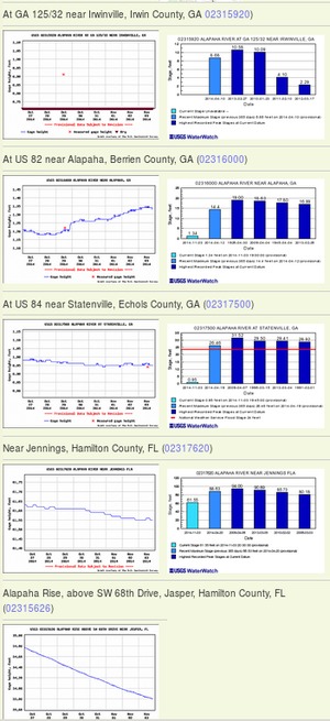 Update 2016-12-23: graphs from water.weather.gov.
Update 2016-05-31: See sea level gage reports.
Update 2015-04-28: Added flood stages and tentative highest safe and lowest boatable water levels, both above the charts for each gauge and in a summary table. If you have data, please let us know.
Here are water level gauges for the Alapaha River in Georgia and Florida, north to south. The graphs should show the current levels at this time, in feet, plus for most of the gauges a bar graph of selected historic levels.
This is a draft of a concept for use with the Alapaha River Water Trail. See also Alapaha River Rainy Season.
It is also a companion to the similar set of graphs for the Withlacoochee and Little Rivers.
See below for the current Alapaha River water level graphs. Continue reading
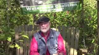 WWALS Ambassador Dave Hetzel explains the
Alapaha River Water Trail: recreation through fishing, swimming, boating,
conservation, and economic benefits through heads on beds, restaurant
customers, gas, and outfitters. Continue reading
WWALS Ambassador Dave Hetzel explains the
Alapaha River Water Trail: recreation through fishing, swimming, boating,
conservation, and economic benefits through heads on beds, restaurant
customers, gas, and outfitters. Continue reading
 At the Alabama Sierra Club Retreat this weekend at Lakepoint State Park
near Eufaula, I’ll be speaking and doing Q&A for an hour:
10AM Saturday 1 November 2014.
If you’re anywhere near Eufaula, Alabama this weekend,
I highly recommend coming to this retreat: it’s got lots
of great talks and activities.
At the Alabama Sierra Club Retreat this weekend at Lakepoint State Park
near Eufaula, I’ll be speaking and doing Q&A for an hour:
10AM Saturday 1 November 2014.
If you’re anywhere near Eufaula, Alabama this weekend,
I highly recommend coming to this retreat: it’s got lots
of great talks and activities.
What do you important points do you think I should mention? What graphics can you send me to include in the slides? No rush: leaving Friday morning, so if you could get me your materials by tomorrow (Thursday), that would be great.
FYI, I will be talking about at least Continue reading
 Received yesterday. -jsq
These pictures are of a dust storm that occurred earlier this year. The dust is from Bill Gates’ farms. Look closely, there is a power transmission tower in the picture. Continue reading