Update 2017-05-17: OK, the water’s gotten too low at the original location, so we’re moving downstream to Woods Ferry Tract Launch to Suwannee Springs.
Update 2017-05-15: The water’s low, but so far it’s a go, plus it’s Hands across the Sands on the Suwannee against the Sabal Trail fracked methane pipeline and for solar power.
Update 2017-04-06: SRWMD tells us Blue Sink Launch is closed, so we’ll be taking out nearby at Swift Creek Launch.
Join WWALS for a brief paddle 8 miles on the Suwannee River through White Springs down to Blue Sink Swift Creek Launch.
This shouldn’t take more than 4 hours paddling or 5 hours including shuttle.
With lunch, swim stops, and bon-bons, of course.
Bring the usual personal flotation device, boat paddles, food, drinking water, warm clothes, and first aid kit. If you don’t have a boat, there are many outfitters, or let us know and many of us have spare boats.
When: 9AM Saturday 20 May 2017
Put In: Suwannee River Wayside Park Ramp, river mile 171.0
From White Springs, travel south on US 41 to the river; the
ramp is on the south side in the town park.

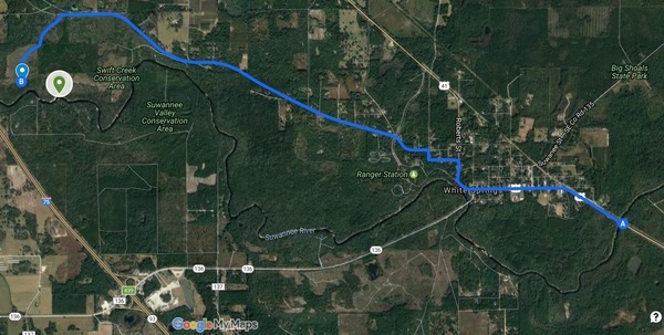
This map drawn using landing directions from the
Suwannee River Wilderness Trail map of
Boat Ramps & Canoe Launches
and SRWMD’s Blue Sink, Rocky Creek, Swift Creek.
Duration: 5 hours
Free: This outing is Free! And we recommend you support the work of WWALS by becoming a WWALS member today!
Shuttle Distance: 6 miles one way
Shuttle duration: 15 minutes one way
Paddle Distance: About 8 miles
Paddle Duration: 4 hours
Take Out:
Swift Creek Launch, river mile 163.2
Swift Creek tract from White Springs:
Take CR 25A west; the entrance to the Swift Creek tract is on the left.
Swift Creek Landing is here:
30.34129, -82.81692, but google maps will route that to the wrong side of the river.
So use 30.34278, -82.8221 to route to Swift Creek Tract, and then it’s left, right to the launch.
Or just follow the shuttle convoy.
Swift-Creek-Map-0001
Gage:
White Springs, FL,
which on March 20th 2016 was at 50.82 feet,
and on April 6th 2016 was at 50.51 feet, with flood at 76 feet
and empty at about 49 48 feet.
Host and Contact: WWALS Outings Committee Chair Phil Hubbard, (229) 740-2016
Maybe you’d like to apply to join the
WWALS Outings Committee.
No boat? No problem! Let us know in advance and probably somebody can loan you one. Or there are many outfitters; see separate web page.
Backup: in case of high or low water is to hike Big Shoals from Big Shoals Tract Launch, 30.352414, -82.687889: from White Springs, travel north on CR 135 to SE 94 Street (Godwin Bridge Road); turn right and follow road to Big Shoals.
For more outings and events as they are posted, see the WWALS calendar.
-jsq, John S. Quarterman, Suwannee RIVERKEEPER®
You can join this fun and work by becoming a WWALS member today!
Short Link:


I would love to go, but I don’t have my own boat. Might there be someone who would like to share their canoe? I am a good paddler! Ist here is a canoe/ Kayak rental available?
Yes, somebody can probably loan you a boat, or there are many outfitters:
http://wwals.com/blog/water-trails/outfitters/
Pingback: White Springs to Swift Creek, Suwannee River, 2017-05-20 | WWALS Watershed Coalition (Suwannee RIVERKEEPER®)