
Update 2018-11-21: Pictures.
Rescheduled due to low water, this time moved and mutated into a hike to the Dead River Sink, starting in the middle of the Alapaha Quest.
Practicing Geologist and WWALS member Dennis James Price will once again lead us through this impressive geological phenomenon. It is an eye opener that will perfectly illustrate the karst topography that is typical for quite a bit of the area where many of our rivers flow. When you see the exposed limestone along the river banks you see the porous rock. However when you see a hole that is capable of swallowing the entire Alapaha for most of the year…. it’s impressive.
When: High noon, Saturday, January 27, 2018
Put In: Meet at Jennings Bluff Launch. From Jennings, Hamilton County, FL, travel south on US 41 to NW 25 Lane; turn left; travel east to NW 82 Court and the entrance into the Suwannee River Water Management District’s Jennings Bluff tract; turn left and follow road to canoe launch.
GPS: 30.567172, -83.039189 (for the entrance to Jennings Bluff Tract)
Take Out: Same.
Bring: Cold weather gear, hiking shoes, and clothes resistant to thorny bushes. No boat needed. Also trash pickers and trash bags: every WWALS outing is also a cleanup.
Join: This outing is Free to WWALS members. Non-members: $10/person. We recommend you support the work of WWALS by becoming a WWALS member today!
Picture by John S. Quarterman for WWALS,
Into the Dead River Sink, June 14, 2015.
Shuttle: None.
Once you get to Suwannee River Water management District (SRWMD)’s Jennings Bluff Tract, you can see on the map below that you then drive about another mile north to get to Jennings Bluff Launch, where we will meet. Then we can walk another half mile or so to the Sink, or first hike up the dry Alapaha River to the Dead River Confluence, and then up the Dead River to the Dead River Sink.

Paddle Distance: Approximately three mile hike.
Duration: Two to three hours, depending on whether we wander around at the Dead River Confluence with the Alapaha River.
Gauge: Jennings Gauge, but unless we get record rain before next weekend, not to worry.

This is one of our more popular outings. We’ve been there by water (when there was water) June 14, 2015:
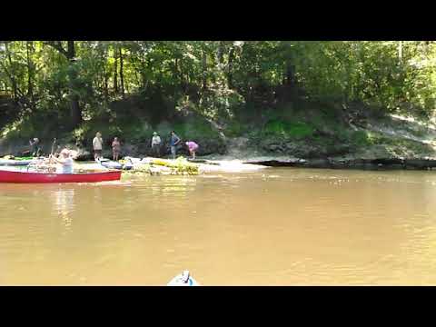
Video by John S. Quarterman for WWALS, June 14, 2015 at Dead River Confluence.
We’ve been there by land November 6, 2016, when the water was very low and we walked on 50-million-year-old oyster beds.
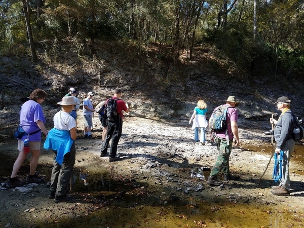
Picture by John S. Quarterman for WWALS of
Geologist Dennis Price at Dead River Confluence, November 6, 2016
We’ve even been there once when it was bright vermillion green from a dye test.
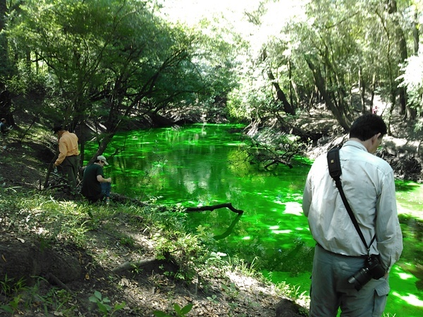
Picture by Gretchen Quarterman for WWALS of June 22, 2016 Dye Test by Suwannee River Water Management District (SRWMD).
The dye came back up several days later in the Alapaha Rise.
Host: Dennis Price
Contact: Phil Hubbard
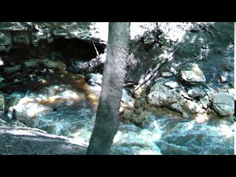
In case it’s not obvious, here is why you don’t want to boat into the Dead River:
Video by John S. Quarterman for WWALS
Into the Dead River Sink, June 14, 2015.
The Dead River is the opposite of a tributary: it’s a distributary, meaning the Alapaha River flows into the Dead River. And then into the Dead River Sink, as described by Samuel Taylor Coleridge: in his poem Kubla Khan:
Where Alph, the sacred river, ran
Through caverns measureless to man
Down to a sunless sea.
So twice five miles of fertile ground
With walls and towers were girdled round;
And there were gardens bright with sinuous rills,
Where blossomed many an incense-bearing tree;
And here were forests ancient as the hills,
Enfolding sunny spots of greenery.But oh! that deep romantic chasm which slanted
Down the green hill athwart a cedarn cover!
A savage place! as holy and enchanted
As e’er beneath a waning moon was haunted
By woman wailing for her demon-lover!
And from this chasm, with ceaseless turmoil seething,
As if this earth in fast thick pants were breathing,
A mighty fountain momently was forced:
Amid whose swift half-intermitted burst
Huge fragments vaulted like rebounding hail,
Or chaffy grain beneath the thresher’s flail:
And mid these dancing rocks at once and ever
It flung up momently the sacred river.
Five miles meandering with a mazy motion
Through wood and dale the sacred river ran,
Then reached the caverns measureless to man,
And sank in tumult to a lifeless ocean; ….
Backup: Well, this is the backup, but if something prevents us from going there, we’ll go to Lime Run Spring Trail at Suwannee River State Park.
More: For more outings and events as they are posted, see the WWALS calendar.
-jsq, John S. Quarterman, Suwannee RIVERKEEPER®
Short Link: