The miners didn’t go away from their site near the Okefenokee Swamp after they withdrew their permit application, so expect another application soon.
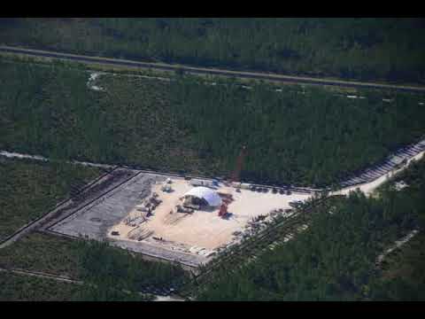
![[Equipment zoom]](https://www.wwals.net/pictures/2020-02-13--tpm-eq-site/20200212_161515.jpg)
Photo: John S. Quarterman for WWALS, Equipment zoom 2020-02-12.
The miners said they would be back, in Mining company withdraws permit application for project near Okefenokee by Nedra Rhone, Atlanta Journal-Constitution, February 9, 2020,
“In an effort to be even more conservative in our approach than we were in our initial application, we have agreed with the U.S. Army Corps of Engineers to reduce the size of the permit area and resubmit new documentation for Continue reading
![[Tribal Grounds west along GA 94 to TPM equipment, 12:38:38, 30.5257540, -82.0411100]](https://www.wwals.net/pictures/2019-10-05--equipment-tpm/triba-grounds-to-TPM-equipment.jpg)
![[Prof. Don Thieme & Can Denizman, 13:30:33, 30.8515417, -83.3452859]](https://www.wwals.net/pictures/2019-11-26--vsu-geology-land-between-the-rivers/20191126_133032.jpg)
![[Donald M. Thieme, Associate Professor, Geology, VSU]](https://www.wwals.net/pictures/2019-10-31--wwals-gosp-troupville-river-camp/big/Thieme_12_5_2019-0001.jpg)
![[2019-12-17--WWALS-GA-EPD-Valdosta-sewage-0001]](https://www.wwals.net/pictures/2019-12-17--wwals-ga-epd-valdosta-sewage/2019-12-17--WWALS-GA-EPD-Valdosta-sewage-0001.jpg)
![[Please Deny Seven Springs permit renewal, Ginnie Springs, Santa Fe River]](https://www.wwals.net/pictures/2019-12-09--wwals-srwmd-nestle/2019-12-09--wwals-srwmd-nestle-0001.jpg)
![[Suwannee Riverkeeper John S. Quarterman beside banner; Mike Roth of OSFR speaking]](https://www.wwals.net/pictures/2019-12-05--no-roads-to-ruin-tlh/20191205_114427.jpg)
![[Nestle-madison-blue-spring]](https://www.wwals.net/pictures/2019-12-10--srwmd-packet/nestle-madison-blue-spring.jpg)