Category Archives: Blueway

Pictures: Withlacoochee River, GA 122 to Franklinville Road 2013-04-20

One of the remotest segments of the Withlacoochee River, yet with easy access, and when the water was high enough. Unter den acer 
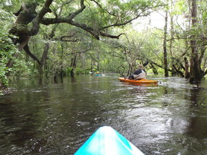
Also one of the least-attended WWALS outings, because we hadn’t really gotten the hang of announcing outings yet. But that just made it more intimate for the three of us who went. I got especially intimate with the river, choosing to swim twice. I always choose to swim when the water comes up to meet me…. Eventually I learned not to lean towards the side you’re tipping towards.

The closest USGS gauge is Continue reading

Skipper Bridge, 17.66 feet, flood level 15 feet

The water level continued up from yesterday, when it was Downstream 31.0116939, -83.2915878 17.66 feet on the USGS guage at Skipper Bridge in Lowndes County, Georgia at 9:46 AM when I took these pictures. Flood stage is 15 feet. It was so high you could have floated over the chain link fence the county put in when it replaced the bridge, thus preventing normal use of this bridge as a Withlacoochee River access point on the Withlacoochee and Little River Water Trail.

-jsq

You can join this fun and work by becoming a WWALS member today!

Downstream panorama 30.9016667, 83.2930556

Continue reading

Withlacoochee River at GA 122

This is a panorama; click on it to see the full picture.

See also Withlacoochee and Little River Water Trail and the pictures I took at Skipper Bridge a few minutes later. There’s a guage at Skipper Bridge, which read 17.66 feet, well above flood level.

-jsq

You can join this fun and work by becoming a WWALS member today!

Pictures: Withlacoochee and Suwannee Rivers, WWALS Outing, 2014-09-21

Gretchen Quarterman took these pictures on the Withlacoochee and Suwannee paddle: springs, shoals, and pipeline 21 Sept 2014. More people 30.4492111, -83.2214667 This was a long outing Chris Mericle organized down two rivers with many people, past springs, shoald, and sinkholes, and past the crossings formerly proposed by Spectra Energy for its Sabal “Sinkhole” Trail fracked methane pipeline before it moved upstream on the Suwannee, as seen 2015-08-15 and 2015-11-15. It was also before we started the Withlacoochee and Little River Water Trail. Click on any small picture below to see a larger one.

-jsq

You can join this fun and work by becoming a WWALS member today!

Continue reading

WWALS Water Trail trailers 7PM tonight at VSU CAUSES mini-film festival 2016-01-23

April Huntley submitted a 90-second video about the Alapaha River Water Trail, and Gretchen Quarterman sent one in about the BIG Little River Paddle Race on the Withlacoochee and Little River Water Trail. Come cheer for them and other local community entries, 7PM tonight, Bailey Auditorium, VSU, Valdosta, Lowndes County, Georgia.

-jsq

You can join this fun and work by becoming a WWALS member today!