Third quiz! Please answer by Saturday, through this google form:
https://docs.google.com/forms/d/e/1FAIpQLSf7q9TdVJ0t4m8g4Pwh5XrIuan9ieYD92O_Rj-DW2Q9iP_UFw/viewform
![[Four images]](https://www.wwals.net/pictures/2020-04-21--quiz3/square.jpg)
Four images for the
third quiz.

Third quiz! Please answer by Saturday, through this google form:
https://docs.google.com/forms/d/e/1FAIpQLSf7q9TdVJ0t4m8g4Pwh5XrIuan9ieYD92O_Rj-DW2Q9iP_UFw/viewform
Four images for the
third quiz.
Shelby Miller did facebook livestream from Banks Lake last night.
In this still, you can see Bobby McKenzie in the raffle kayak, Continue reading
Yes, you can boat, fish, and swim on rivers and lakes during the stay-home period, in both Florida and Georgia, as long as you keep your distance. Don’t gather in large groups unless you want your favorite river or lake access to get closed, not to mention unless you want to get or transmit the novel coronavirus that causes COVID-19, for which there is no vaccine. Stay six feet apart, no large groups (usually no more than 10), and on the water stay at least 10 feet apart or 50 feet apart in Florida.
Below is a snapshot of conditions today. Check on your local park or ramp or launch before going for current conditions.
Also check on bacterial conditions, especially since last night’s rain.
Here’s a handy map that shows status of Florida boat ramps and launches. Red means closed. Blue means open.
Tony Acevedo, SaltStrong, 31 March 2020, This Map Shows Which Boat Ramps Are Closed & Which Are Open, Continue reading
Shelby Miller will go live on the facebook event at 7:15 PM tonight. She’ll be streaming for an hour through sunset at 7:51 PM. She will have to miss moonrise in order to be out well before the 9PM Lanier County curfew.
![[Sunset spire (MM)]](https://www.wwals.net/pictures/2020-02-09--banks-lake-full-moon/86266798_10217939016239312_2122588741947097088_o.jpg)
Photo: Monica McKenzie, Sunset spire (MM), Banks Lake, 2020-02-09.
Bobby McKenzie will be on Banks Lake with Shelby, paddling the raffle kayak, and also taking video for later publication. Continue reading
Update 2020-04-08: Shelby Miller will be livestreaming on the facebook event at 7:15 PM for an hour. Bobby McKenzie will be there in the raffle kayak. You can stay home and watch.
Due to the virus pandemic, WWALS is cancelling the next Full Moon Paddle at Banks Lake, formerly scheduled for sunset, Wednesday, April 8, 2020, with that lunar-monthly series to resume later.
But we have livestreams, videos, and online events, as well as outings and events planned for months from now, while WWALS advocacy continues. You can help.
Shelby Miller will livestream from Banks Lake at the originally-scheduled date and time for the Banks Lake Full Pink Moon Paddle, so you can see as if you were there.
![[Sunset behind paddlers]](https://www.wwals.net/pictures/2020-02-09--banks-lake-full-moon/83343222_3003771079635074_2187311012879794176_o.jpg)
Photo: Gretchen Quarterman, Sunset behind paddlers,
Banks Lake, 2020-02-09
It probably would be possible to hold this Full Moon Paddle, since there is no shuttle so no cramming into vehicles, people could put their boats in one by one, and on the lake everybody is far apart, but we’re not going to do that.
Lakeland and Lanier County have declared a 9PM curfew, as I believe have Nashville and Adel, Georgia, in Berrien and Cook Counties, and there is a case confirmed in Clinch County. Lowndes County and all its cities have issued a “voluntary” stay-home order prohibiting gatherings of 10 or more people, as has the state of Georgia. Madison County, Florida, similarly is trying for no groups of 10 or more. While some of these orders currently expire on April 6, don’t be surprised if they get extended.
WWALS does not want to provide any opportunity for anybody to violate any of those things.
So, please stay home and help stop the spread of the novel Coronavirus and the COVID-19 disease it causes.
We’re not postponing this outing: we’re cancelling. Whenever the curfews and the like are clear enough, we will resume our series of lunar-monthly WWALS Full Moon Paddles on Banks Lake.
While you’re home, please post your pictures and videos of your outings on lakes, rivers, creeks, swamps, springs, etc. Here are some from the Full Storm Moon Paddle on Banks Lake, February 9, 2020.
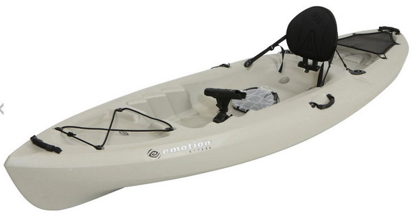
Feel free to get a ticket to the WWALS kayak raffle of an Emotion Stealth 11 Sit-On-Top Kayak with Carlisle Paddle.
You can attend some of our virtual events, such as Continue reading
Due to the pandemic of the novel Coronavirus, and to help prevent the spread of the virus-caused disease COVID-19, WWALS and FORB are postponing the Eighth Annual BIG Little River Paddle Race (BLRPR), until a date to be announced later.
Anyone who has bought a BLRPR ticket and wants a refund, let us know. Otherwise, all tickets will remain valid at the eventual rescheduled date and time.
If Georgia state parks are open at the originally scheduled date and race start time of 9:30 AM, Saturday, April 25, 2020, one or two WWALS members will livestream from the BLRPR site and race course; six feet apart, of course. Stay tuned for details.
For more Continue reading
Due to the many health considerations of our volunteers and their families, WWALS, exercising an abundance of caution, will not send the information booth to festivals for the rest of March 2020.

This means we are cancelling our appearances at:
While we are sorry to have to do that, the risk is beyond simple infection of our booth volunteers, which would be bad enough. The novel coronavirus is airborne, causes a disease that Continue reading
Update 2020-04-08: Shelby Miller will be livestreaming on the facebook event at 7:15 PM for an hour. Bobby McKenzie will be there in the raffle kayak. You can stay home and watch.
Update 2020-03-25: Gone Virtual. Stay home and watch Shelby Miller livestream at the original date and time.
Leisurely sunset paddle and watch the April Full Pink Moon rise over the lake.
Don’t forget there’s still a Full Worm Moon Paddle in March, and the first-ever WWALS Gear Swap earlier that same day.
Banks Lake National Wildlife Refuge is in the Grand Bay–Banks Lake ecosystem. We usually see birds, bats and alligators. Sunsets are usually spectacular, and the full moon over the tree tops reflected in the lake is a sight to see.
When: Gather 6:45 PM, launch 7:15 PM, Wednesday, April 8, 2020
Moon and sun: Moonrise 8:46 PM, Sunset 7:51 PM
Put In: Banks Lake Boat Ramp, 307 Georgia 122, Lakeland, GA 31635, in Lanier County.
Take Out: Banks Lake Boat Ramp
Bring: the usual personal flotation device, boat paddles, food, drinking water, warm clothes, and first aid kit. Also trash pickers and trash bags: every WWALS outing is also a cleanup.
Boats: Kayaks are available to borrow but please let us know at least 2 days prior to the event. Bring your own if you have it.
Free: This outing is free to WWALS members, and $10 (ten dollars) for non-members. We recommend you support the work of WWALS by becoming a WWALS member today!
![[Front coming in]](https://www.wwals.net/pictures/2020-02-09--banks-lake-full-moon/84834019_3003771126301736_3489149865546481664_o.jpg)
Photo: Gretchen Quarterman, Front coming in,
2020-02-09.
Sent to the media Wednesday (see also PDF):
FOR IMMEDIATE RELEASE
Gear Swap at Banks Lake: find a new boat, maybe try it out, or get rid of an old one
Lakeland, Georgia, February 26, 2020 — Here’s something new: a fun-filled day of promoting paddle activities and trying various boat designs, at Banks Lake on the first Saturday of March. This new event by WWALS Watershed Coalition (WWALS) should help paddlers find a new boat or get rid of an old one. If the owner permits, you can try out a boat right there on Banks Lake. This should help get everyone ready to kick off a new paddling season in the great Suwannee River Basin.
![[Bret Miller, NWXpeditions, outfitting a paddler]](https://www.wwals.net/pictures/2020-02-09--banks-lake-full-moon/83720544_3003771582968357_4082578358599155712_o.jpg)
Photo: Gretchen Quarterman, of Bret Miller of NWXpeditions, 2020-02-09
WWALS Outings Chair Bobby McKenzie, who thought up this Gear Swap, says, “Many thanks to Continue reading
Leisurely sunset paddle and watch the full moon over the lake. The moon will be up early this time, at 4:25 PM, before we gather to paddle, because the March full moon is actually on Monday, but we’re going early on Saturday. You can come in even earlier for Gear Swap and stay for the Full Worm Moon Paddle!
This is a rare full moon name that comes from southeastern U.S. native Americans: Full Worm Moon, because earthworms are crawling about already. It’s also called Crow Moon, (Snow) Crust Moon, Sap Moon, or Lenten Moon. More about those names at FarmersAlmanac.com.
Banks Lake National Wildlife Refuge is in the Grand Bay–Banks Lake ecosystem. We usually see birds, bats and alligators. Sunsets are usually spectacular, and the full moon over the tree tops reflected in the lake is a sight to see.
When: Gather 5:30 PM, launch 5:45 PM, Saturday, March 7, 2020
Moon and sun: Moonrise 4:25 PM, Sunset 6:35 PM
Put In: Banks Lake Boat Ramp, 307 Georgia 122, Lakeland, GA 31635, in Lanier County.
Take Out: Banks Lake Boat Ramp
Bring: the usual personal flotation device, boat paddles, food, drinking water, warm clothes, and first aid kit. Also trash pickers and trash bags: every WWALS outing is also a cleanup.
Boats: Kayaks are available to borrow but please let us know at least 2 days prior to the event. Bring your own if you have it.
Free: This outing is free to WWALS members, and $10 (ten dollars) for non-members. We recommend you support the work of WWALS by becoming a WWALS member today!
![[Contrasting moon color (NWX)]](https://www.wwals.net/pictures/2020-02-09--banks-lake-full-moon/85122468_3003780899634092_2522986088864153600_o.jpg)
Photo: Bret Miller, Contrasting moon color, 2020-02-09.
![[Bobby staying dry]](https://www.wwals.net/pictures/2020-04-09--banks-lake-full-moon-livestream/bobby-staying-dry.jpg)
![[Florida]](https://www.wwals.net/pictures/2020-04-09--fl-boat-ramps-status/florida.jpg)
![[Paddlers golden in sunset]](https://www.wwals.net/pictures/2020-02-09--banks-lake-full-moon/84086310_3003771112968404_2601747611455062016_o.jpg)
![[Closer]](https://www.wwals.net/pictures/gretchen/2019-04-27--wwals-blrpr/42-closer-bib-13.jpg)
![[2020-02-26--gear-swap-pr-0001]](https://www.wwals.net/pictures/2020-03-07--gear-swap/2020-02-26--gear-swap-pr-0001.jpg)