
Let’s cut to the chase in the letter we filed with FERC yesterday:
11. Historic new circumstances add up
The sun never set on the British Empire. Until it did.
No one circumstance ended that Empire, but it is easy to point at major events that accelerated its demise, such as the independence of India and the Suez Incident. Its fall started after the illusion of its invincibility was shattered by Gandhi’s campaign of civil disobedience and other events such as World War II.
The illusion of invincibility of the inland colonial empire of pipelines has been shattered by recent court orders about the ACP, DAPL, and others, and especially by the shut down of the Dakota Access Pipeline and the shuttering of the Constitution Pipeline and the Atlantic Coast Pipeline. All of those pipelines were expected to be built, and DAPL actually was built before being ordered to shut down and empty. Now the world knows that pipelines are not inevitable.
All these pipeline projects, like Sabal Trail, were opposed by nonviolent protests and political and legal actions. All those methods of opposition, combined with the sea-change in progress to renewable energy, eventually added up to a new and significantly different world than that in which Sabal Trail was permitted or re-permitted.
The shut down of DAPL and the abandonment of ACP as well as the court rejection of tolling orders make it a new world even since FERC’s June 19, 2020, Order granting a rehearing on Sierra Club’s motion.
FERC should initiate a new [Supplemental Environmental Impact Statement] EIS that should take into account Sabal Trail’s own track record of leaks and sinkholes, as well as leaks and accidents from [Liquid Natural Gas] LNG export and LNG transport in rail cars, the speeding demise of fossil fuels as evidenced by record low LNG export prices and bankruptcies of frackers, the court rejections of DAPL, ACP, and tolling orders and how much of Sabal Trail could never have been built through environmental justice communities without tolling orders, the coronavirus pandemic, and the rapid rise of renewable solar, wind, and battery power as evidenced by FPL and Sabal Trail partners Duke and NextEra, as well as by FERC’s own numbers. All of those new and significant circumstances make pipelines such as Sabal Trail toxic stranded assets, dangerous to the bank accounts of their investors, as well as to the environment, justice, and human health.
Conclusion
For the reasons stated above, WWALS asks FERC to grant Sierra Club’s motion for stay of the Commission’s letter order of April 22, 2020, to halt Sabal Trail Phase II, and to commence a Supplemental Environmental Impact Statement (SEIS) taking into account all of the above new and significant circumstances.
![[Third-party inspection, recission, stay, SEIS]](https://www.wwals.net/pictures/2020-07-20--wwals-brief-ferc-sabal-trail-phase-ii-rehearing/big/2020-07-20--WWALS-Brief-CP15-17-005-0001.jpg)
Third-party inspection, recission, stay, SEIS
For those who are not familiar with tolling orders, they are basically how, after the Federal Energy Regulatory Commission (FERC) gives federal eminent domain to a private pipeline company, FERC lets that pipeline company take land before any payment to the landowner or even any agreement is reached. Without tolling orders, it’s not clear the FERC will ever get another pipeline built.
Here’s a longer explanation. Continue reading
![[Paddle Map: WWALS SRWT]](https://www.wwals.net/pictures/2020-08-29--bike-paddle-suwannee/map-wwals-srwt.jpg)
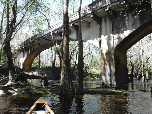
![[Helen Chaney: Suwannee Riverkeeper under Stone Bridge]](https://www.wwals.net/pictures/2020-05-16--stone-bridge-paddle/98282704_717724335669695_2747634499310321664_n.jpg)
![[Platts: Sabal Trail Phase II Compressor Stations]](https://www.wwals.net/pictures/2020-04-23--ferc-stt-platts/platts-stt-compressors-phase-ii.jpg)
![[Site Plan]](https://www.wwals.net/pictures/2019-01-17--stt-phase-ii-request/20190117-5096-33348792-0042.jpg)
![[Aerial]](https://www.wwals.net/pictures/2019-01-17--stt-phase-ii-request/20190117-5096-33348792-0046.jpg)
![[This Week]](https://www.wwals.net/pictures/2020-04-08--wq/2020-04-06-08--raindown.jpg)
![[River Styx]](https://www.wwals.net/pictures/2020-04-10--tpm-watersheds/river-styx.jpg)
![[Florida]](https://www.wwals.net/pictures/2020-04-09--fl-boat-ramps-status/florida.jpg)
![[An inch of rain and bad water quality]](https://www.wwals.net/pictures/2020-04-02--wq/2020-03-31--2020-04-02--baddown.jpg)