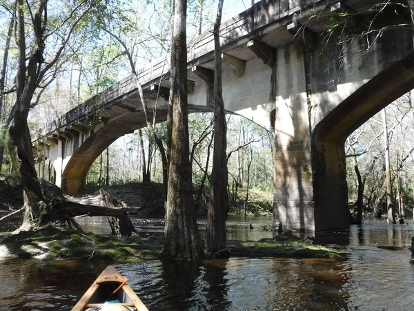
Update 2020-05-26: Pictures: Stone Bridge paddle from Cook County Boat Ramp (GA 76) 2020-05-16.
Update 2020-05-21: Three Little River Landings in Swim Guide 2020-05-21
Update 2020-05-20: Clean weekend 2020-05-17.
Changed to put in at Cook County Boat Ramp on GA 76 and paddle upstream past Stone Bridge, and then back. This avoids the outings problem during the stay-home period of the novel coronavirus pandemic: no shuttle, so no crowding together. Yes, boating is not just permitted, it is encouraged by the state of Georgia; see Florida and Georgia Boat Ramps Status 2020-04-09. To keep it that way, everyone please remember to stay 6 feet apart on land and 10 feet apart on the water.
This is a leisurely paddle on a very seldom-paddled stretch of wild south Georgia blackwater river, the Little River, between Adel and Barney.
When: Gather 9:30 AM, launch 10 AM, Saturday, May 16, 2020
Put In:
Cook County Boat Ramp,
Mile 31.41. 966 Quitman Highway (GA 76), Adel, GA 31620, in Cook County.
Between Adel and Barney, southeast side of GA 76, northeast side (left bank) of Little River, gravel ramp. Also known as Cook County Landing (GDOT).
Left or right bank means when facing downstream.
Landmark 1: Stone Bridge, 31.04962, -83.49932, Mile 32.36, about a mile upstream from Cook County Boat Ramp.
Take Out: Same as Put In.
Bring: the usual personal flotation device, boat paddles, food, drinking water, warm clothes, and first aid kit. Also trash pickers and trash bags: every WWALS outing is also a cleanup. These days, a facemask would not be amiss.
Free: This outing is free to WWALS members, and $10 (ten dollars) for non-members. We recommend you support the work of WWALS by becoming a WWALS member today!

Photo: Burt Kornegay, March 2018, of
Stone Bridge over Little River, SW of Adel, GA.
More about Stone Bridge, including more pictures:
Stone Bridge, Little River, by Dan Phillips 2016-08-01.
Duration: 2 hours (depending on how far upstream we go)
Shuttle: None, so no crowding together.
Landmark 2: LOPSG RR Bridge, 31.05202, -83.500841, about a thousand feet upstream from Stone Bridge. That’s LOPSG: Live Oak, Perry & South Georgia Railway. Currently owned by Georgia & Florida Railway.
Landmark 3: Creek 03110204001330, right bank, 31.04821941847359, -83.507413114153152, a couple thousand feet upstream from the LOPSG RR Bridge. What is the name of this creek, which starts way up near Barney, and comes down across Moody Road (CR 181) and Herring Road (CR 180)?
Landmark 4: Creek 03110204004993, left bank, 31.053433218465496, -83.520682914132507, a mile or so upstream from the previous creek. What is the name of this creek, which starts up at Plantation Road?
Paddle distance: 1-2 miles
Paddle duration: 2-4 hours
Host: Bobby McKenzie
Contact: Bobby McKenzie
Backup: in case of high or low water is: Reed Bingham State Park (west) upstream to Red Roberts Landing (reverse of the course for BLRPR).
Blueway: This paddle is on part of the Withlacoochee and Little River Water Trail.
More: For more WWALS outings and events as they are posted, see the WWALS calendar or the WWALS outings and events web page. WWALS members also get an upcoming list in the Tannin Times newsletter.
-jsq, John S. Quarterman, Suwannee RIVERKEEPER®
You can join this fun and work by becoming a WWALS member today!
Short Link:
