Kind of high (movie):

Picture and video by John S. Quarterman for WWALS Watershed Coalition (WWALS),
Berrien County, Georgia, 8 July 2013.
-jsq

Kind of high (movie):
Picture and video by John S. Quarterman for WWALS Watershed Coalition (WWALS),
Berrien County, Georgia, 8 July 2013.
-jsq
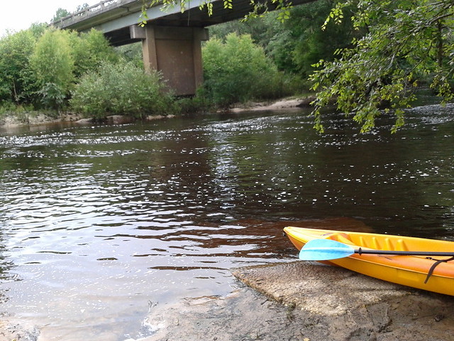
A few pictures from today’s WWALS Outing on the Withlacoochee River from Clyattville-Nankin Road to GA 31, with 12 people in 8 boats (4 kayaks, 4 canoes).
Gage height, US 84 Quitman: 3.25 feet (86.75 feet NAVD 1988).
Withlacoochee River at Clyattville-Nankin Landing:
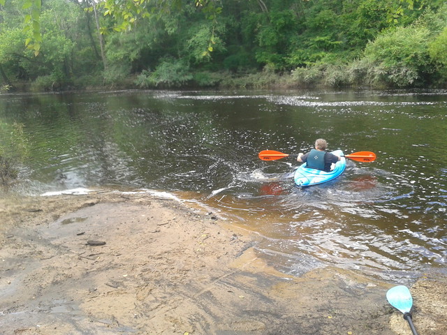
Heather sets out:
The June WWALS outing is from Clyattville-Nankin Road to Horn Bridge on
 Madison Highway (GA 31) on the Withlacoochee River.
Meet at the Clyattville-Nankin Road putin at 9AM, put in at 10AM, Saturday, 22 June 2013.
Join the
facebook event if you like.
See you there!
Madison Highway (GA 31) on the Withlacoochee River.
Meet at the Clyattville-Nankin Road putin at 9AM, put in at 10AM, Saturday, 22 June 2013.
Join the
facebook event if you like.
See you there!
Update 20 June 2013: How are we getting back to our vehicles with this trip? We’ll deposit all the boats at the put-in (Clyattville-Nankin Road), take most of the vehicles down to the take-out (Horn Bridge on Madison Highway aka GA 31), carpool in a few vehicles back to the put-in, and float down the river.
Tom Baird described this nine-mile two-hour trip as:
The section includes where Clyatt Mill Creek enters, a truly fun set of rapids (two drops) at the Ga – Fla border, a very nice Second Magnitude Spring (that I have yet to find the correct name), the remains of the enormous abandoned trestle over the river of the Georgia & Florida Railroad,or Ole God Forsaken as it was nicknamed, the ghost town of Olympia on the Georgia side, and several Indian quarry sites. It is along this section that the river cuts deeply enough that the banks switch from sand banks to limerock cliffs. Paddle distance is about 9 miles, so a little over two hours paddling time. There are plenty of places to stop and look around.
There are shoals right at the state line, so beware, esp. if you’re in a canoe. The book Canoeing and Kayaking Georgia, by Susanne Welander, Bob Sehlinger, and Don Otey (2004) says: Continue reading
Approved 12 June 2013 by unanimous vote of the WWALS board, Dave has mailed a signed copy to the Georgia Public Service Commission, and I will go read it to the PSC Tuesday morning at 10 AM 18 June 2013, at their hearing about
Docket 36498, Georgia Power Company’s 2013 Integrated Resource Plan and Application for Decertification of Various Unitsand
Docket 36499, Application for the Certification of Amended Demand Side Management Plan
Y’all come! -jsq
From: WWALS Watershed Coalition, Inc.
3338 Country Club Road #L336
Valdosta, GA 31605
12 June 2013To: Georgia
Public Service Commission
244 Washington Street, SW
Atlanta GA, 30334-9052
Dear Public Service Commissioners and Staff,
The recent rains have swollen our blackwater rivers, Withlacoochee, Willacoochee, Alapaha, and Little, under our longleaf pines and Spanish-moss-covered oaks, and filled up the tea-colored tannin waters in our frog-singing pocosin cypress swamps here in central South Georgia. But that was only a dent in our protracted drought that ranges from mild to extreme, with projections not much better.

We do not need more traditional big baseload power plants gulping down our river or aquifer water when solar and wind power use far less, and those renewables are now at grid parity with coal, natural gas, and nuclear.
Power plants are thirsty, as the Union of Concerned Scientists pointed out in a 2011 report, “Freshwater Use by U.S. Power Plants: Electricity’s Thirst for a Precious Resource”.
Much of the water used to cool power plants evaporates, and is Continue reading
PDF of Dissolved Oxygen Dynamics in the Upper Suwannee River Basin by Prof. George Vellidis, Crop & Soil Sciences Dept., University of Georgia, Tifton, GA. He used these slides when he discussed the dynamics of dissolved oxygen concentrations in WWALS waterways at the 8 May 2013 WWALS board meeting.

More later.
-jsq
 Water issues strongly affect economic development, so I talked about
the new WWALS Watershed Coalition at the
16 April 2013 Board Meeting
of the Valdosta-Lowndes County Industrial Authority.
Water issues strongly affect economic development, so I talked about
the new WWALS Watershed Coalition at the
16 April 2013 Board Meeting
of the Valdosta-Lowndes County Industrial Authority.
The VDT declined to speak, so I did. After apologizing for no okra today, I commended the Authority for talking about the missing agenda items and for mentioning due diligence and flood control.
Mostly I talked about the new WWALS Watershed Coalition,
www.wwals.net,
incorporated in June 2012, which is about watershed issues
such as flooding, water quality, and invasive species related to the Withlacoochee, Willacoochee,
Alapaha, and Little River System.
I mentioned
arsenic in some local well water,
which
the Department of Health has finally said should be tested,
three years after
Janet McMahan discovered it was a problem.
 I invited VLCIA board and staff to two upcoming WWALS events:
WWALS board meetings are every second Wednesday of the month, usually at the IHOP in Adel because it’s centrally located. WWALS is communicating with Valdosta and various organizations about flooding and other watershed-wide issues, which in my opinion have to do with things like too much clearcutting without consideration for where the water goes, too much development without consideration for what the impervious surface would do, (to my surprise, the Executive Director and several board members nodded along with that) so it was good to hear them mention flood containment.
Here’s the video:
Arsenic, Outings, and Flooding: WWALS Watershed Coalition
Regular Meeting, Valdosta-Lowndes County Industrial Authority (VLCIA),
Norman Bennett, Tom Call, Roy Copeland, Chairman, Mary Gooding, Jerry Jennett,
Andrea Schruijer, Executive Director, J. Stephen Gupton, Attorney, Tom Davis, CPA, Allan Ricketts, Project Manager,S. Meghan Duke, Public Relations & Marketing Manager, Lu Williams, Operations Manager,
Video by John S. Quarterman for Lowndes Area Knowledge Exchange (LAKE), Valdosta, Lowndes County, Georgia, 16 April 2013.
-jsq
 American Rivers
released Wednesday its list of
America’s Most Endangered Rivers® 2013,
and our neighbor to the west, the Flint River, is on it.
Some of the Flint’s problems are the same as in our WWALS watersheds,
including
drought and floods.
The writeup doesn’t mention it, but I think
the arsenic wellwater problem
extends over there, too.
The Flint does have Atlanta at its headwaters,
and Flint Riverkeeper and others just had to fight off
a legislative attempt to frack Flint water for Atlanta.
However,
the overpumping problem was apparently already much worse
in parts of our watersheds way back in 1980.
And the Flint doesn’t have
the Lowndes County Commission, which prefers to
close its only public access to the Alapaha River
rather than
listen to 350 people wanting to keep it open for demonstrated
public uses. -jsq
American Rivers
released Wednesday its list of
America’s Most Endangered Rivers® 2013,
and our neighbor to the west, the Flint River, is on it.
Some of the Flint’s problems are the same as in our WWALS watersheds,
including
drought and floods.
The writeup doesn’t mention it, but I think
the arsenic wellwater problem
extends over there, too.
The Flint does have Atlanta at its headwaters,
and Flint Riverkeeper and others just had to fight off
a legislative attempt to frack Flint water for Atlanta.
However,
the overpumping problem was apparently already much worse
in parts of our watersheds way back in 1980.
And the Flint doesn’t have
the Lowndes County Commission, which prefers to
close its only public access to the Alapaha River
rather than
listen to 350 people wanting to keep it open for demonstrated
public uses. -jsq
| Flint River, Georgia | Take Action |
At Risk: Water supply for communities, farms, recreation, and wildlifeContinue reading
Threat: Outdated water managementThe Flint River provides water for over one million people, 10,000 farms, unique wildlife, and 300 miles of exceptional fishing and paddling. Despite being in a historically wet area of the country, in recent years many Flint River tributaries are drying up completely and the river’s low flows have dropped dramatically.
American Rivers and Flint Riverkeeper are working in collaboration with diverse partners to restore the flows and health of the Flint. The State of Georgia also has a role to play and must act to protect the Flint in droughts and at all times to safeguard the river’s health for today and future generations.
The Threat
The Flint is a river running dry. The reasons are many, and include
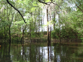
Come paddle the Withlacoochee River from GA 122 to Franklinville, 10 AM 20 April 2013, in the monthly WWALS outing.
Update 2016-02-01: Pictures by Gretchen Quarterman.
Franklinville Road Bridge (closed):

Withlacoochee River:
Continue readingGoogling for Diane Shearer’s “A-lap-a-WHAT?” at Weekend for Rivers by Georgia River Network 31 March 2012, I ran across “Ala…alapa…what?” by Christy Ramsey, 22 Sep 2011.
-jsq
