Category Archives: River

Alapaha River @ GA 135, Berrien County south of Willacoochee

Update 2020-09-07: This location is now known as Nashville Landing.

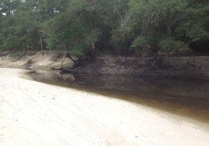
300x210 There is a long sandy beach upstream from the bridge, which is a popular summer hangout for locals., in GA 135 Alapaha River access, by Bret Wagenhorst, for WWALS.net, 14 September 2014 There is a long sandy beach upstream from the bridge, which is a popular summer hangout for locals.

Bret Wagenhorst took these pictures 14 September 2014.

See also Alapaha River Water Trail. Continue reading

Alapaha River access at Riverside Church

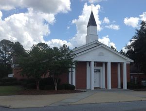
300x229 Riverside Church, in Alapaha River access at Riverside Church, by Bret Wagenhorst, 14 September 2014 Nine miles south of Willacoochee on GA 135 and twelve miles east of Nashville on GA 76, which turns into Riverside Road as it crosses GA 135, is this traditional put-in for the Alapaha River. However, it is not clear that access is public, so we can’t recommend it unless that is clarified. Continue reading

Canoeing Guide to the Withlacoochee River c. 1979

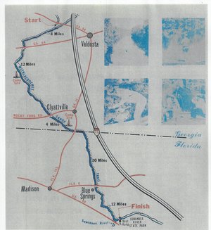
300x327 Map, in Canoe Guide to the Withlacoochee River Trail, by John S. Quarterman, for WWALS.net, 0  1979 Including both Florida and Georgia, a second river got map and guide attention back in the 1970s. To be updated in the Withlacoochee River Water Trail.

This Withlacoochee River guide is courtesy of John Leonard, Executive Director of the Southern Georgia Regional Commission (SGRC).


I would speculate that it is the most recent of the three guides posted thus far, because the Continue reading

Little Alapaha River

Probably the least-known tributary of the Alapaha River, the Little Alapaha River is so shy it disappears underground between Jennings and Jasper, Florida.

The Little Alapaha River arises in Echols County, Georgia, just before it flows into Hamilton County, Florida, where it falls into a sinkhole west of Jasper, briefly reappearing before vanishing again. Theoretically it is a tributary of the Alapaha River, but it is not clear the waters of the Little Alapaha River ever reach the Alapaha River aboveground. Like the Alapaha River, the Little Alapaha’s sinkhole disappearance happens at the Cody Scarp. Chris Graham found this very interesting reference, Continue reading

Alapaha River rainy season?

Veteran boater Bret Wagenhorst asked:

300x214 Alapaha, GA 02316000, in Alapaha River gauge heights over time, by John S. Quarterman, for WWALS.net, 1 December 2014 Is there a defined “rainy season” on the Alapaha? I have seen the water high in December, March, July, and once even in September.

Good question!

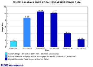
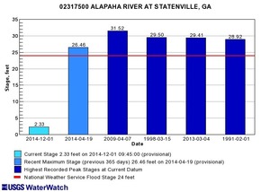
300x214 Irwinville, GA 02315920, in Alapaha River gauge heights over time, by John S. Quarterman, for WWALS.net, 1 December 2014 Looking at the record high water levels for the gauges, they’re all in April, March, February, or January.

Also, the only January one is for Irwinville, the farthest upstream, which also had its highest ever in February with that January high only slightly lower.

300x214 Statenville, GA 02317500, in Alapaha River gauge heights over time, by John S. Quarterman, for WWALS.net, 1 December 2014 Downstream, Continue reading

Canoeing Guide to the Alapaha River c. 1979

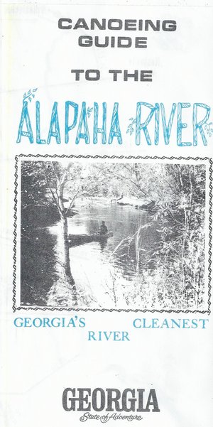
300x601 Cover: Georgias Cleanest River, in Canoeing Guide to the Alapaha River, by John S. Quarterman, for WWALS.net, 0  1979 Here’s a different guide to the Alapaha River from the one WWALS previously received; this one is courtesy of John Leonard, Executive Director of the Southern Georgia Regional Commission (SGRC). The Alapaha River Water Trail WWALS is currently developing is merely a continuation of this more than three decade old Alapaha Canoe Trail.

John Leonard said that when he started at the predecessor of the SGRC in 1980, calls came in frequently asking about water levels on the Alapaha River. It took him a while to realize why: the Alapaha River Trail had been written up in Southern Living! He did not have Continue reading

Sabal Trail on GWC Dirty Dozen: contamination, sinkholes, aquifer –WCTV

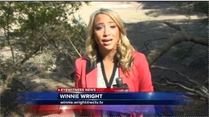
WCTV’s Winnie Wright interviewed VSU’s Don Thieme, and VSU’s Can Denizman navigated her to the the Cherry Creek sinkhole site for part of her report about 300x169 Sinkhole opened suddenly --Winnie Wright, in GWC Dirty Dozen Sabal Trail on WCTV, by John S. Quarterman, for WWALS.net, 26 November 2014 the Withlacoochee River in Georgia Water Coalition Dirty Dozen 2014 Item 9 as threatened by the Sabal Trail pipeline. Sabal Trail’s Andrea Grover is “disappointed” in being on the Dirty Dozen; does she also find it “hard to believe” like Sabal Trail’s well-documented eminent domain threats?

Winnie Wright, WCTV, 26 November 2014, Sabal Trail Pipeline Environmental Concerns Cited In Annual ‘Dirty Dozen’ Report, Continue reading

Dirty Dozen, sinkhole, aquifer, drinking water, and corrosion –WWALS to FERC about Sabal Trail

“There is no reason anyone in WWALS’ watersheds should accept any risk for the profit of Williams Company, Spectra Energy, and FPL, when any need for the Sabal Trail pipeline is unproven, and in any case the pipeline does not serve anyone in Georgia.”

Filed with FERC 15 November 2014, and appeared in FERC’s ecomment system 17 November 2014 (PDF).

WWALS Watershed Coalition, Inc.
3338 Country Club Road #L336
Valdosta, GA 31605
15 November 2014

VIA ELECTRONIC FILING
Ms. Kimberly Bose
Federal Energy Regulatory Commission
888 First Street NE
Washington, DC 20426

Re: Southeast Market Pipelines Project,
Sabal Trail Transmission, LLC Docket No PFl4-1-000
Williams Transco Hillabee Expansion Project, LLC Docket No PFl4-6-000

Dear Ms. Bose,

I applaud FERC for getting Sabal Trail to move off of the Withlacoochee River in Hamilton County, Florida. However, the same karst limestone geology underlies the same Withlacoochee River and the Floridan Aquifer in Brooks and Lowndes Counties, Georgia, and WWALS Watershed Coalition continues Continue reading

Alapaha River Sink 2014-11-11

Deanna Mericle posted on facebook 11 November 2014,

Chris and I hiked the riverbed of the Alapaha River and found the other sink!

Other as in different from the Dead River Sink. Continue reading

Rivers go underground at the Cody Scarp

The Alapaha River goes underground because the underlying karst limestone rises in what’s called the Cody Scarp, which runs across north Florida. Other rivers that go underground there include the Little Alapaha River and the Santa Fe River. The Withlacoochee River does not go underground, but it does sprout Madison Blue Spring.


Source: Bulletin of the Geological Society of America, vol. 123, no. 3-4, p. 457.

Here’s a cutaway diagram of how all that works underground: Continue reading