Tag Archives: Don Davis

Videos: Lowndes County buys land from Helen Tapp for Troupville Nature Park and River Camp 2022-12-13

Update 2022-12-23: Videos: Troupville Nature Park and River Camp, Trash, Cleanups –Helen Tapp & Suwannee Riverkeeper @ Scott James Radio 2022-12-15.

Landowner Helen Tapp spoke a week ago at the Lowndes County Commission about their historic purchase of her 71+ acres to add to 49 VLPRA acres to make a Troupville Nature Park and River Camp.

Below are videos and transcript of what she said about her vision and hopes for the site. For the entire meeting, see the Continue reading

Pictures: Dam, Troupville, Little River, GA 133, 2022-11-03

Update 2022-11-07: a few more dam pictures in here: Troupville River Park Scouting 2022-07-02.

About halfway between Troupville Boat Ramp and the Troup Bridge (the GA 133 Little River Bridge), are these remains of an old dam.

Phillip Williams pointed this out some time back.

Maybe Don Davis can turn up some records of this dam.

[Timbers seen from downstream, 11:05:42, 30.8519297, -83.3472014]
Timbers seen from downstream, 11:05:42, 30.8519297, -83.3472014 in the WWALS Map of the Withlacoochee and Little River Water Trail

Bridge pilings are vertical, not horizontal.

Horizontal timbers would make sense to hold a dam in place. Right next to Troupville would be a good place for a mill, which would need a dam. Continue reading

Mayor, Council, volunteers, helped WWALS clean up Sugar Creek and Withlacoochee River 2022-05-07

Update 2023-07-22: Pictures: Sugar Creek Withlacoochee River on-land cleanup 2023-07-22.

Update 2023-05-18: Sugar Creek to Troupville, Withlacoochee River Cleanup 2023-07-22.

Update 2022-05-16: Trash at No Water No Beer 2022-05-07.

When Russell says don’t bring a boat to a cleanup, bring a boat for use as a garbage scow. Fortunately, Valdosta Mayor Scott James brought a boat. He and Council Andy Gibbs helped clean up at Sugar Creek and the Withlacoochee River, in that Council district. We filled that kayak with trash, floated it down the river, loaded it on the Mayor’s truck, and he drove it straight to No Water No Beer at Georgia Beer Co. (his idea).

The Mayor and Phil Hubbard sawed off some deadfalls, clearing passage in the creek. Thanks to them and all the other volunteers for this cleanup. Special thanks to Russell for organizing it.

[Sugar Creek, Withlacoochee River, trash, Valdosta Mayor and Council]
Sugar Creek, Withlacoochee River, trash, Valdosta Mayor and Council

Of course, cleanups don’t solve the trash problem. Fortunately, Continue reading

Water Trail signs to Lowndes County Museum 2019-07-30

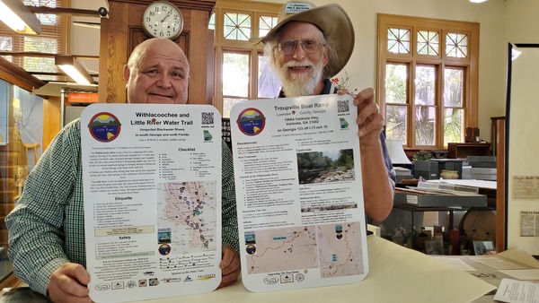
Don Davis of the Lowndes County Museum had asked for copies of some water trail signs, so today I delivered to him duplicates of the ones for Troupville Boat Ramp:

WLRWT Signs, Lowndes County Museum

One of them is about the entire Withlacoochee and Little River Water Trail (WLRWT). As befits a museum, this one is actually a prototype, with Continue reading

Agatized Coral, Withlacoochee River 2019-06-15

Semi-precious gemstones in the Withlacoochee River bed, during Day 2 of #PaddleGA2019, above Knights Ferry Boat Ramp.

[Withlacoochee River, Lowndes County]
Withlacoochee River, Lowndes County

Continue reading

When the water was really high at Spook Bridge 1928-08-19

The Withlacoochee River is higher this morning than yesterday, so conditions are fine for #PaddleGA2019!

Those people on Spook Bridge during the 1928 flood were crazy:

[During flood of-1928 with Blue Springs sign]
During flood of-1928 with Blue Springs sign

Don Davis of the Lowndes County Historical Society, who sent these old pictures, wrote:

Constructed in 1921? the bridge in the 1928 flood photo is the old US84 (GA38) bridge that the group will paddle under as “Spook Bridge.”

According to the USGS Quitman (US 84) gauge, that flood crested on August 19, 1928, which actually wasn’t quite as high as in 2013, 1948, or 2009.

Historic Crests
(1) 118.17 ft on 04/05/2009
(2) 115.20 ft on 04/04/1948
(3) 114.98 ft on 03/01/2013
(4) 114.80 ft on 08/19/1928
(5) 114.29 ft on 02/13/1986

Gauges

Right now the USGS Quitman (US 84) gauge reads 86.15 feet NAVD 88, which is well above the 85.9 feet Joe Cook wanted for Paddle Georgia. And it has been rising since yesterday morning. The fellow who left his kayak at the bottom of Troupville Boat Ramp may be in for a surprise….

[Quitman]
Quitman

Upstream, the gauges are even higher, and that water is coming downstream.

Hahira at Continue reading