Update 2021-05-13: Water levels are going down, so probably just the first stretch, from Langdale Park to the Salty Snapper; stay tuned. Meanwhile, you can probably schedule a shuttle for $2 with Valdosta on-demand, and hear all about it on radio TV, with Suwannee Riverkeeper and Scott James on 92.1 FM.
Update 2021-05-12: 10% lunch discount for paddlers at The Salty Snapper Saturday.
Update 2021-05-08: Water Trail signs planted at Langdale Park Boat Ramp 2021-05-06.
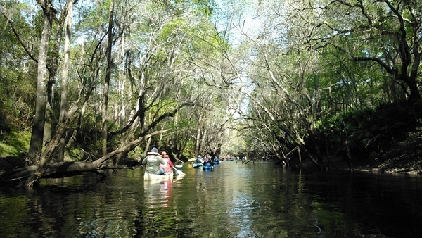
Leisurely paddle promoting ecotourism as we sieze the rare optimal water levels to paddle from Langdale Park to Troupville Boat Ramp as we stop in halfway for lunch at the Salty Snapper. Each participant will be responsible for purchasing their own lunch. This is a pop-up paddle meaning that we have a rare window to paddle this section of the river in favorable conditions for a group. This also means that conditions can rapidly change. We will keep regular posts on this event to ensure optimal water levels for this paddle. We will gather at Langdale Park at 9am and perform a team shuttle at 9:30 returning to Langdale and launching at 10:00 am. We will arrive at the Salty Snapper (3 miles) for lunch/beverages around 11:30 shortly after they open. Lunch should wrap up around 12:30 and paddle on down to Troupville Boat Ramp (4 miles) arriving and finishing up around 2:30pm.
When: Gather 9 AM, launch 10 AM, end 3 PM, Saturday, May 15, 2021
Put In: Langdale Park Boat Ramp, 3781 N. Valdosta Rd., Valdosta, GA 31602, in Lowndes County.
GPS: 30.88747, -83.32395
High Water Put In: If Langdale Park is closed due to high water, we will put in at US 41 Landing, 3966 N Valdosta Rd, Valdosta, GA 31602. This landing is tricky, so we will post further directions if we have to use it.
Take Out: Troupville Boat Ramp, 19664 Valdosta Hwy, Valdosta, GA 31602: on GA 133 off I-75 exit 18.
Bring: the usual personal flotation device, boat, paddles, food, drinking water, warm clothes, and first aid kit. Also trash pickers and trash bags: every WWALS outing is also a cleanup.
Free: As a one-time experiment, we are waiving the outing fee for this one pop-up outing. The fee has never seemed to be a deterrent to anybody paddling, but we’ll see if anybody says they came because this one was free. Everyone will still have to sign in so everyone will be covered by WWALS insurance.
All WWALS outings are free to WWALS members.
We recommend you support the work of WWALS by
becoming a WWALS member today!
https://wwals.net/donations/#join
![[Langdale Park Boat Ramp sign, map]](https://www.wwals.net/pictures/2021-05-15--salty-snapper-pop-up-paddle/many.jpg)
Langdale Park Boat Ramp sign, map

![[Clean results, Withlacoochee River down and up, Swim Guide]](https://www.wwals.net/pictures/2021-04-01--wq/many.jpg)
![[Watch out: US 41, GA 133, Knights Ferry, Nankin, Withlacoochee River]](https://www.wwals.net/pictures/2020-12-21--wq/many.jpg)
![[Driveway, pavillion, streetlight, logjam, sandbar (rotated)]](https://www.wwals.net/pictures/2020-11-29--langdale-park-upgrade/manyrot.jpg)
