Tag Archives: Phil Hubbard

Suwannee Riverkeeper Vessel 2017-01-14

Heading downstream On the Suwannee River on a fine Saturday afternoon, advocating for our rivers and the Floridan Aquifer and against the Sabal “Sinkhole” Trail fracked methane pipeline. The Waterkeeper Alliance requires each member to have a vessel. Here’s the Suwannee RIVERKEEPER® vessel.

Thanks to Tom H. Johnson, Jr. for paddling and for taking the picture. Thanks to Bret and April Huntley of Paint and Body Concepts for putting the name on the sides. Thanks to Phil Hubbard for the paddles and other assistance. And thanks to Lynne Buchanan for riding along, photographing, and helping paddle.

 -jsq, John S. Quarterman, Suwannee RIVERKEEPER®

You can join this fun and work by becoming a WWALS member today!

Heading downstream

Continue reading

Pictures: Redoux Suwannee River Roline to Cypress Creek 2016-09-05

Update 2019-05-01: To be continued, Saturday, May 4, 2019, Cypress Creek South Launch to Cone Bridge Ramp, Suwannee River.

Boats on both sides of the rapids 30.5204800, -82.7180800 Rapids, a spring, a creek, lunch with the WWALS banner on a beach, old bridge pylons, spring, some rapids, Rocky Creek, the WWALS banner at lunch, Turner Bridge pylons, and a painting boat on the Suwannee River on a WWALS Saturday Outing rescheduled to Monday due to Hurricane Hermine. Plus some videos and a google map.

Spring 30.5579067, -82.7266533

Continue reading

Fargo to Roline, Suwannee River, 2017-03-18

Update 2017-03-17: Yes, there’s plenty of water and the weather forecast is fine.

A long downstream paddle on the historic Suwannee River from Georgia into Florida. Fargo Launch @ US 441, Suwannee River In the winter-spring rainy season the water should be high and fast.

Bring the usual personal flotation device, boat paddles, food, drinking water, warm clothes, and first aid kit. There is no good place to take out before the end point, so be prepared to paddle all day. With lunch, swim stops, and bon-bons, of course.

When: 7AM Saturday, March 18th, 2017

Put In: Fargo Ramp

GPS: 30.68297, -82.56105

Take Out: Roline Launch

Duration: 10 hours

Event: facebook, meetup

Free: This outing is Free! And we recommend you support the work of WWALS by becoming a WWALS member today!
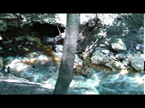
Continue reading

Cook County Landing (GA 76) to Folsom Bridge (GA 122), Little River 20162017-01-14

Not a great boat ramp but public access it is. In January the water should be up like a year ago at this three-hour tour of the idyllic Little River between Brooks County and Cook and Lowndes Counties, Georgia. There should be no need to drag boats, like there was in July.

When: 10 AM Saturday January 14th 2017

Put In: Cook County Landing (GA 76) between Adel, Cook County and Barney, Brooks County, Georgia

GPS Coordinates: Continue reading

From the air: US 84 HDD Withlacoochee River Sabal Trail 2016-10-22

Update 2016-10-24: Questions filed with FERC in Docket CP15-17 as Accession Number 20161024-5049 and emailed to USACE and GA-EPD (PDF).

Extreme closeup yellow in Withlacoochee River, 30.7952780, -83.4524840 What is that yellow thing in the river, Sabal Trail? Is that a sinkhole you’ve marked at the Lowndes County HDD site? And does blue pipe mean thinner for rural areas like your executive from Houston told us in WWALS v Sabal Trail & FDEP?

FERC gave you permission to Continue reading

Little River Scouting 2016-07-10

My phone’s pedometer said I walked four miles of the six miles of this section of the Little River, with many fish, two white birds, lots of sand bars, some eroded bluffs, not a lot of trash after we got beyond the GA 76 bridge, and only one spot of invasive species (Japanese climbing fern).

Walk along home

This section would be better with about half a foot more water. The USGS GA 122 Little River gage showed about 3.71 feet for July 10th 2016, so let’s say at least 4.2 feet would be good. This is because there are many sand bars, including one directly upstream from the GA 122 bridge, where the water level is much closer to zero when that gage says 3.71.

Following up a report, Continue reading

#NoDAPL #NoSabalTrail @ Suwannee River State Park 2016-09-13

Update 2016-12-09: Here are directions to Suwannee River Campsites at 30.414, -83.159167. Facing the boat ramp, up to your right you’ll see a trail head. Follow the trail into the woods along the river bank. The river bends left, then right. Shortly after the right bend is the crossing, at 30.407379, -83.156494. Sabal Trail has marked its path in the woods; stay off of their easement but follow it until you come to a field where you should be able to see the HDD site. Send back lots of pictures. For maps and aerial pictures, see Sabal Trail maps digitized. Much more information here. And you may want to ask the CEO of college-savings mutual fund Virginia529 why her company is the biggest mutual fund stockholder in the stranded investment of Spectra Energy.

Yes, Sabal Trail wants to cross the Suwannee River IN Suwannee River State Park.


How many pipelines do we want? Continue reading

Roline Redoux is on for Monday on the Suwannee River 2016-09-05

“We’re on for Monday morning! River excellent condition,” Roline Launch says expedition leader Phil Hubbard, reporting from the Suwannee River just now. “Maybe 2 feet higher. Flow is perfect,” he added.

Earlier he said helpfully, “I’m stopping at Hardee’s in Jasper to grab a biscuit around 9:15 if anyone needs help finding the launch site.”

About an essential outing ingredient, Gretchen Quarterman says: “I just baked bon-bons!”

For outing details, see the original post, Redoux Suwannee River Roline to Cypress Creek.

-jsq

You can join this fun and work by becoming a WWALS member today!

Continue reading

Delay Roline Redoux as Suwannee River rises after Hurricane Hermine 2016-09-05

Update 2016-09-04: “We’re on for Monday morning! River excellent condition,” says expedition leader Phil Hubbard.

With water still coming downstream from Hurricane Hermine and storms following, USGS WSPF1 at White Springs expedition leader Phil Hubbard says:

I’m thinking looking at the weather forecast, the only safe call we can make today is to delay till Monday pend river level. The rain probability is actually higher on Sunday but looks good for Monday.

So we’re rescheduling Redoux Roline for 10 AM Monday morning September 5th 2016, still at Roline.

At lest now now we know the Suwannee River won’t be too low!

Hoping to see you there. Details are still in the first blog post.

-jsq

You can join this fun and work by becoming a WWALS member today!

Continue reading

Tropical Storm Hermine and Roline Redoux 2016-09-03

It looks like Hermine will have moved along east by Saturday, or at least by Sunday, which is the fallback date for the WWALS paddle outing this weekend from Redoux Suwannee River Roline to Cypress Creek. We won’t be able to tell for a day or so what the situation will be, but so far we’re still planning on Saturday morning. Expedition leader Phil Hubbard will make a determination before then.

-jsq

You can join this fun and work by becoming a WWALS member today!