Tag Archives: Sullivan Launch

Avoid Withlacoochee River from Knights Ferry to Confluence with Suwannee River 2020-01-08

Update 2020-01-11: Signs in Georgia on Withlacoochee River and new data; thanks Lowndes County and SRWMD 2020-01-10.

It would be prudent to avoid contact with the Withlacoochee River from Knights Ferry Boat Ramp all the way to the Suwannee River, due to test results from Lowndes County, Georgia, and the Florida Department of Environmental Protection (FDEP).

[Avoid red area]
Avoid red area.
WWALS Map of Landings in the Suwannee River Basin.

The problem access points would seem to include Knights Ferry Boat Ramp, Nankin Boat Ramp, and State Line Boat Ramp in Georgia, and in Florida Sullivan Launch, Florida Campsites Ramp, Madison Blue Spring, Madison Boat Ramp, and Allen Ramp on the Withlacoochee River. I believe Hamilton County also has a warning sign upstream on the Suwannee River at Suwannee River Campsites. There’s a sign at Madison Blue Spring, and I’d bet there’s one at Suwannee River State Park Ramp. There will be signs in Georgia today, one way or another.

Here is an excerpt from the latest FDEP data, received this morning. The entire updated FDEP spreadsheet is Continue reading

Valdosta sewage from Sugar Creek to Florida 2019-01-01 2020-01-01

Update 2020-01-03 Valdosta Sewage Public Meeting, Valdosta City Hall Annex, 2020-01-08.

You can see Valdosta’s sewage going down the Withlacoochee River as the high red numbers in these composite tables WWALS has cobbled together from various data sources (all acknowledged below).

Early on, the sewage apparently mostly sat in Sugar Creek downstream from the spill site, due to low water and no rain.

[Early (12/10-12/18)]
Early (12/10-12/18)

Most of the Georgia numbers in above table are from Valdosta Utilities data. The ones marked with a W are WWALS data using the Georgia Adopt-a-Stream 3M Petrifilms method.

Fecal coliform numbers started dropping in Sugar Creek at Gornto Road on December 14, and were much more acceptable by December 15 and 16th. Where did the sewage go? Continue reading

Cleanup finishing at Flying J, Exit 2, I-75, Lowndes County, GA 2019-12-10

Update 2022-03-02: Trash beyond fence not finished at Flying J, I-75 exit 2 2022-02-26.

Thanks, Flying J and Lowndes County Code Enforcement, for finishing cleaning up what was a huge mess of trash at Exit 2 on I-75 in Lowndes County, Georgia.

[Fence keeping trash in]
Fence keeping trash in

Back in August, a WWALS member called Code Enforcement, and I followed up. Code Enforcement responded quickly, came to an agreement with the company, and Continue reading

Trash in wetlands at Flying J, Exit 2, I-75 2019-08-23

Update 2019-12-19: Cleanup finishing at Flying J, Exit 2, I-75, Lowndes County, GA 2019-12-10.

I must compliment Lowndes County Code Enforcement, the Flying J, Dynamis, and Deep South Sanitation, about this cleanup at the Flying J, Exit 2, I-75, Lake Park, Georgia, about a mile from the GA-FL line.

[Trash in gap]
Trash in gap

On August 23, 2019, I sent this picture and the location to Lowndes County Code Enforcement:

[Still more trash]
Still more trash

Code Enforcement Director Mindy Bates responded within the hour: Continue reading

Low water reroute of Paddle Georgia 2019-06-05

The same day as Jay Ricks, Paddle Georgia #PaddleGA2019, PaddleGA2019, sent an exploratory expedition, with WWALS board member Bobby McKenzie acting as local guide.

Canoe, Shoals

PADDLE GEORGIA 2019 LOW WATER UPDATE!!!!!

Due to low water levels on the upper Withlacoochee, the Georgia River Network staff and Paddle Georgia safety advisory committee has concluded that if water levels do not rise significantly, we will be forced to abandon our original Paddle Georgia route entirely.

This will mean all paddlers will travel on our “alternate route” which will involve repeating our original Day 4 and Day 5 routes during the week and paddling only a portion of our Day 3 route.

We have made this decision in an effort to Continue reading

Paddle Georgia, Withlacoochee and Suwannee Rivers, into Florida 2019-06-15-21

Update 2019-06-08: Reroute due to lack of rain.

FOR IMMEDIATE RELEASE

Hahira, GA, February 13, 2019 — From next to the largest Suwannee River Basin city, Valdosta, to between some of the smallest, Mayo and Luraville, Paddle Georgia brings 300 people this summer to venture for the first time across the state line from Georgia to Florida, on the Little, Withlacoochee, and Suwannee Rivers, June 15 through 21, 2019.

Banners picture,
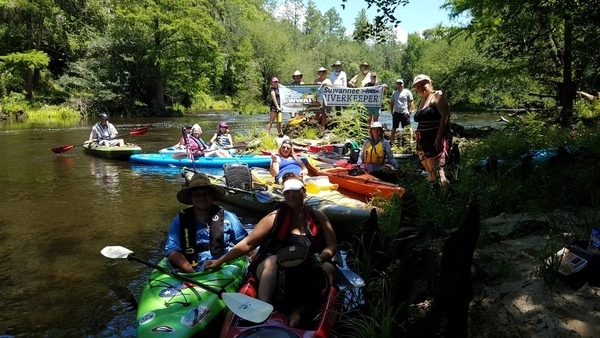
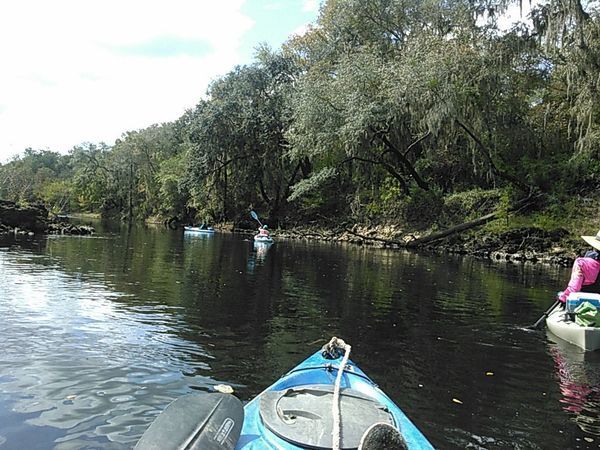
WWALS Withlacoochee River outing 2017-06-24

“Five years ago I suggested our Withlacoochee River to Joe Cook for Paddle Georgia, and he went one better, adding the Suwannee River, past two of the few second-magnitude springs in Georgia, McIntyre and Arnold, and two of the famous first-magnitude Florida Springs: Madison Blue and Lafayette,” said Suwannee Riverkeeper John S. Quarterman. 
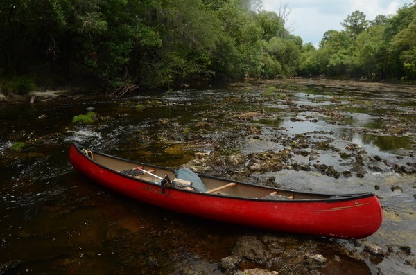
“Plus Spook Bridge and the orphaned railroad trestle near Madison, with many shoals and rapids at the GA-FL line! Special thanks to The Langdale Company for permission to take out just below Spook Bridge. Personally, I like that this paddle starts at my birthplace in Valdosta, Georgia and ends at my grandmother’s birthplace at the ferry site for Luraville, Florida.”

This event is organized by Paddle Georgia, with catered dinners and buses to and from the rivers. WWALS is assisting, for example by organizing the Spook Bridge takeout, and by pointing out many sites that non-locals might miss, ranging from springs, and Withlacoochee River agates, and the halberd-leaf rosemallow, whose blooms last only one day, to perpetual bothers such as Valdosta’s Withlacoochee Wastewater Treatment Plant, the Continue reading

A fine day on the Withlacoochee River from Sullivan Landing to Madison Blue Spring 2017-06-24

Nineteen paddlers had a good time on a breezy summer Withlacoochee River Saturday from Sullivan Launch to Madison Blue Spring. The water was a foot higher (41.27 feet) than two years ago (42.56 feet at the USGS Madison (FL 6) gage), but there were still plenty of rapids, which gained us three new Fallers!

Banners picture, Say water bottle! No, don’t, you’ll fall in! Hm, but then you’ll win a Fallers Award.

Every WWALS outing is also a cleanup, and we collected Continue reading

Water higher than two years ago, Sullivan to Madison Blue, Withlacoochee River, 2017-06-24

Two years ago the water level was 41.27 feet and today it’s 42.56 at the USGS Madison (FL 6) gage, so the Withlacoochee River is fine for today’s WWALS outing from Sullivan Launch to Madison Blue Spring; follow the link for details. Also WWALS Outings Chair Phil Hubbard visited the put-in and the take-out yesterday, and reports the water is fine.

Here are some pictures from the same route two years ago, 24 October 2015.

Onwards

We won’t see as many rapids today since with the water more than a foot higher we’ll float over some of those shoals, but we’ll see some, and many springs. Bring swimming clothes and also trash bags, because every outing is also a cleanup.

 -jsq, John S. Quarterman, Suwannee RIVERKEEPER®

You can join this fun and work by becoming a WWALS member today!

State line to Sullivan Launch, Withlacoochee River 2016-10-09

Sunday morning on the tea-colored Withlacoochee River in north Florida in fall: come join us!

Shuttle When: 10AM Sunday October 9th 2016

Put in: Madison Highway on the Georgia side, also known as GA 31 Ramp (SRWMD) or State Line Ramp (GA DNR) or CR 145 Bridge Launch (FDEP). 30.635933, -83.311103

Directions: Continue reading

Pictures: Sullivan Launch to Madison Blue Spring Withlacoochee River 2015-10-24

Update 2022-07-20: better picture labels and access.

A fine day, balmy, breezy, sunny, with springs and rapids and fine company, Onwards from Hardee Spring 30.5444069, -83.2500076 from Sullivan Launch to Madison Blue Spring on the Withlacoochee River, in the October WWALS Outing, October 24, 2015. This is part of the Withlacoochee and Little River Water Trail, and you can join the committee!

Below are some pictures. Click on any small picture to see a larger version. Pictured: many shoals and rapids. The Pinetta gage (pictured) read 6.4 feet. Any lower and more dragging boats would have been necessary. Lots of cypress, oaks, pines, and other native species.

Pinetta Gage steps and old-style measure 30.5957374, -83.2598038 Not pictured: a large turtle, numerous birds (heron, ibis, hawk, buzzard, others), and fish (mullet, bass). No gators. Very few invasive species, except the notorious Japanese climbing fern.

Coming up next: Continue reading