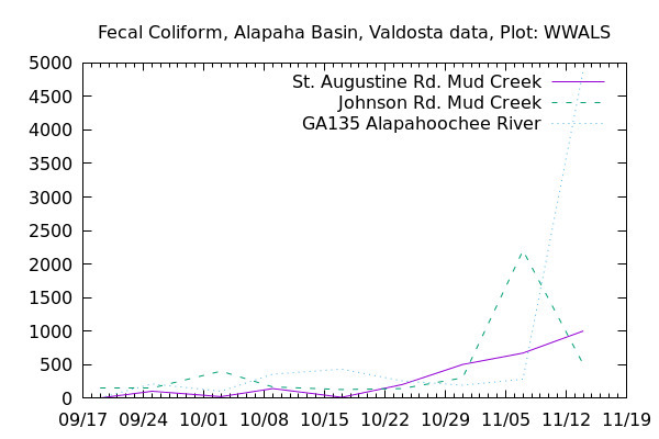
The Alapahoochee River at the GA-FL line measured ten times the EPA limit on Fecal coliform again this Wednesday, November 28, 2018.

It does not seem to be coming downriver from Valdosta. Continue reading

The Alapahoochee River at the GA-FL line measured ten times the EPA limit on Fecal coliform again this Wednesday, November 28, 2018.
It does not seem to be coming downriver from Valdosta. Continue reading
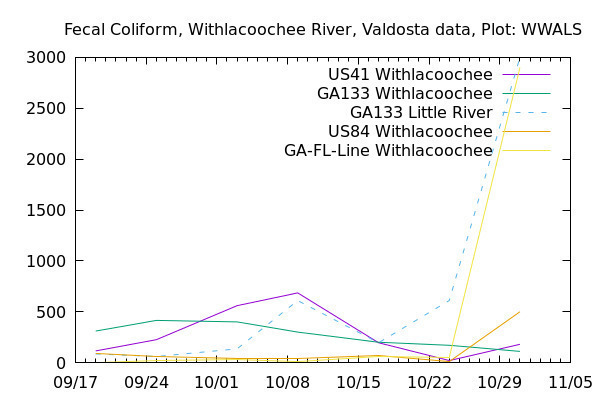
Suddenly, all the fecal coliform readings are down. Was there a first flush from the rain on November 14 that caused the high readings of that day, and all that washed down the rivers within a week?
At US 41 (North Valdosta Road), the Withlacoochee River was actually in minor flood several of the intervening days, according to the USGS US 41 (Valdosta) Gauge. Continue reading
Twenty five times the state limit for Fecal coliform could be a problem. What got into the Alapahoochee River last week?
If you want to help find out what’s getting into our rivers, you can Continue reading
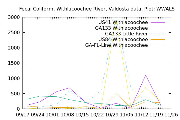
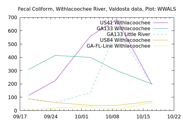
Was there rain Wednesday? That might explain the sudden spikes at US 41 on the Withlacoochee River, at GA 133 on the Little River, and at State Line on the Withlacoochee River. We can guess that the rains Thursday and Friday (today) have washed away whatever that very odd spike was at the state line.
Thanks to Valdosta Utilities and Valdosta City Clerk Teresa Bolden for sending this Wednesday’s Valdosta water quality testing data before the end of Friday. For more contact, see https://wwals.net/issues/vww/.
It’s a very odd spike, because Continue reading
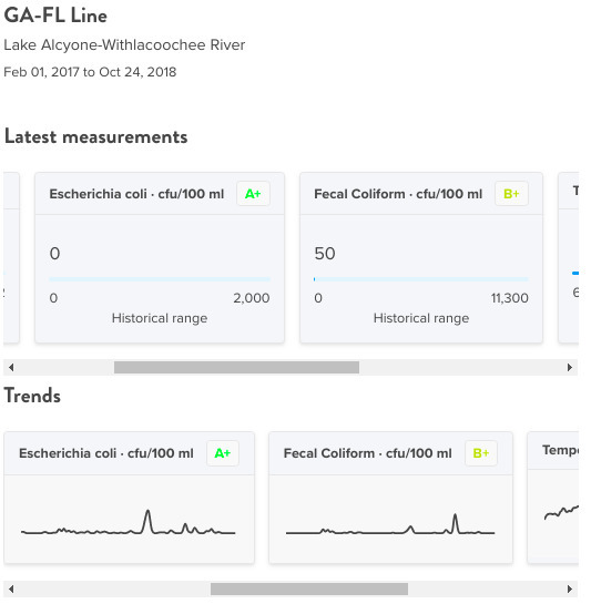
Valdosta’s bacterial counts are always low at State Line Ramp (Mozell Spells), where we moved the WWALS Boomerang paddle race from Georgia to Florida and back.
Things were generally better last week in the Withlacoochee Basin, except for the Little River at GA 133, just above Troupville Boat Ramp. Continue reading
Fecal coliform went down last week to 195 at US 41 and 200 at GA 133 on the Withlacoochee River, right at the Georgia limit of 200 cfu/100 ml, while rising slightly at US 41 and at the GA-FL line at the Madison Highway Horn Ferry Bridge, according to Valdosta’s testing.
Wednesday of this week, we still don’t know, because Continue reading
Once again, as during Hurricane Irma, recent rains are causing flooding on Suwannee River tributaries.
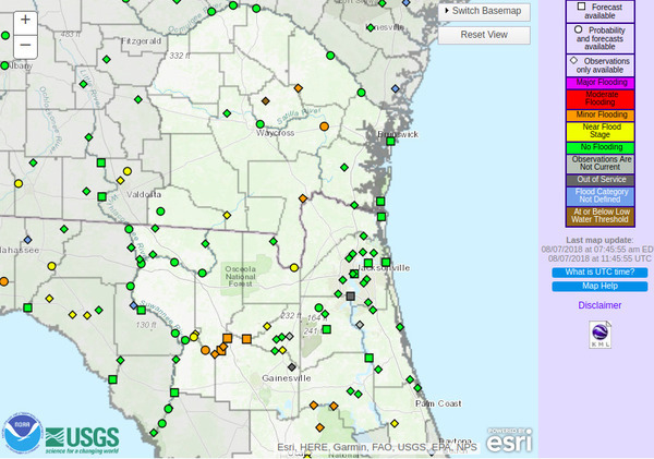
The Withlacoochee River at Skipper Bridge and at US 41 (North Valdosta Road) is in Near Flood Stage, as is the Suwannee River at Fargo, and the New River near Lake Butler.
Already in Minor Flooding are Continue reading
You can see on these maps that the Suwannee River Basin is massively agricultural, except where it’s forestry or swamp or other wetlands. Thus it’s no wonder that most of the nitrate runoff problem here is due to agriculture, as shown in the Basin Management Action Plans (BMAPs).
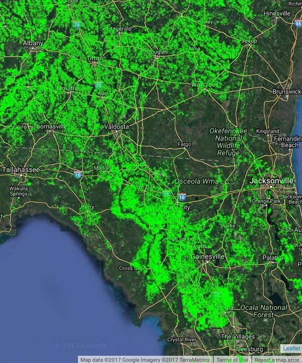
WWALS Science Committee Chair Tom Potter points to this Global Croplands map to illustrate the BMAP issues. The question remains of whether agricultural best management practices as advocated in the recent BMAP meetings will be sufficient to deal with the problem, considering they haven’t decreased it in the past decade.
Global Croplands About: Continue reading
Looks like we may finally see Action stage tomorrow on the Withlacoochee River above Valdosta @ Skipper Bridge Road. This is upstream from Valdosta’s Withlacoochee Wastewater Treatment Plant, so it’s a good thing that didn’t spill during Irma. The Alapaha River at Statenville peaked Tuesday and probably would be a fine ride (what shoals?) today. The New and The Santa Fe Rivers are still flooding, and that’s still raising the Suwannee River all the way to the Gulf, and there’s minor flooding all the way up at Fargo, so another surge of high levels may follow on the Suwannee. The I-75 Santa Fe River bridge never did close.

2017-09-17 Withlacoochee River above Valdosta @ Skipper Bridge Road
The Suwannee River at White Springs peaked Continue reading
Update 2017-09-15: On the seventh day.
Update 2017-09-15: Added Suwannee River at Wilcox @ US 19, plus another image for the Gage Map.
Hurricane Irma flooded the Suwannee River at White Springs, the Santa Fe River especially at Fort White, with a new record for the New River new Lake Butler. It did not flood the Withlacoochee or Alapaha Rivers.

2017-09-14 Suwannee River at White Springs
FDOT says the I-75 bridge over the Santa Fe River Continue reading