Tag Archives: valve

Posted: Valdosta Country Club Sewage Spill, six days afterwards 2019-08-27

The GA-EPD person who enters the data was on vacation, but eventually the Valdosta Country Club sewage spill appeared in GA-EPD’s online reports, on August 27, 2019, with this:

“Note: Initial 24-hour spill notification received by EPD 8/21, via phone. Entered 8/26 due to employee vacation.”

As I noted to GA-EPD, this is a good example of a case where an automated email alert could have let them and us all know when it appeared. Alabama has been doing that for two years now, and Florida for almost as long.
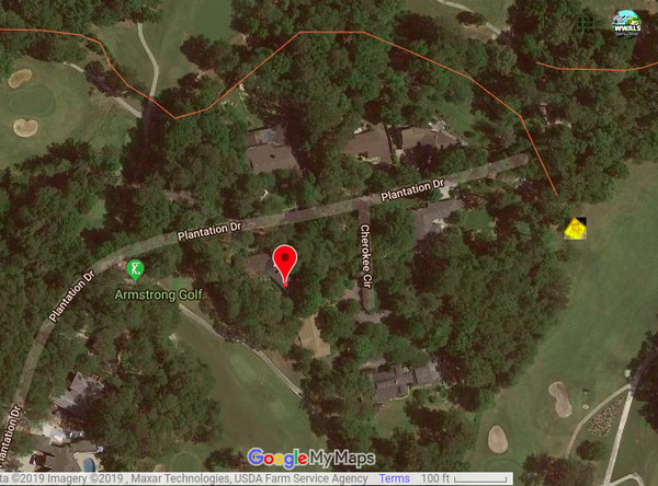
3353 Plantation Drive is not the spill location, Google Map
Red marker: 3353 Plantation Drive. Yellow diamond sign: actual spill location.

That entry included a more precise address than Valdosta had previously reported: 3353 Plantation Drive. Unfortunately, that address is still incorrect. As I have pointed out to GA-EPD, the spill was Continue reading

Valdosta sewage sign, golf course, Valdosta Country Club, Stillhouse Branch 2019-08-23

Friday we found the warning sign on the Valdosta Country Club green for the Wednesday force main sewage spill, thanks to Valdosta Utilities Environmental Manager Scott Fowler, who told me where it was. Sara Jay has tested downstream for WWALS, and maybe we can get the Valdosta water quality testing data, as well. Although there is some ambiguity as to which way downstream is.

[Sewage Spill]
Sewage Spill

“It stinks,” said a man on a golf cart on the green, as I was taking pictures. Continue reading

US 41 access to Withlacoochee River

On the north side of US 41, there’s good access from Val Del Road to the Withlacoochee River.

Turnoff from Val Del Road 30.8961964, -83.3201294 From US 41 (North Valdosta Road), turn north on Val Del Road, and your next right is a turnoff to a gravelled road that bends sharply right into the woods, which leads back to the north side of US 41 and down to the Withlacoochee River. It was a bit muddy in the rain this morning, but there were no big potholes, and the river slope is easy access. The river was high, 9.8 feet, but still well below the 15 foot flood level on the US 41 Gage on this bridge.

Withlacoochee River and US 41 bridge

Continue reading