Tag Archives: Stillhouse Branch

Five Rivers Clean 2022-06-09

2022-06-17: WWALS Thursday tests clean, but Valdosta bad Wednesday results for US 41 and GA 122, Withlacoochee River 2022-06-16.

All tested clean: Little, Withlacoochee, Alapaha, Ichetucknee, and Santa Fe Rivers, for Thursday. Sure, those were only a few test sites on each river. But there’s been little rain, none predicted, and no sewage spills reported. So happy swimming, boating, and fishing this weekend.

[Chart, River, Swim Guide]
Chart, River, Swim Guide

Thanks to Continue reading

Clean Rivers 2022-06-02

Update 2022-06-11: Five Rivers Clean 2022-06-09.

Seventh week: all rivers clean! Happy swimming, fishing, and boating in the Little, Withlacoochee, and Alapaha Rivers.

For example, tomorrow morning, Florida Campsites to Allen Ramp, Withlacoochee River 2022-06-04.

Of course, there can be undetected local water quality problems (see below). But all the WWALS sites tested Thursday got clean results. While there is a prediction of rain today and tomorrow, if it’s like what we’ve been seeing, it will be light and won’t wash much contamination into the river. No sewage spills have been reported in Georgia or Florida in the past week. So have a good weekend.

The most recent results we have from Valdosta are for Wednesday upstream and Wednesday of last week downstream. Those were all clean, too.

But earlier contamination was detected in Valdosta results. Continue reading

Posted: Valdosta Country Club Sewage Spill, six days afterwards 2019-08-27

The GA-EPD person who enters the data was on vacation, but eventually the Valdosta Country Club sewage spill appeared in GA-EPD’s online reports, on August 27, 2019, with this:

“Note: Initial 24-hour spill notification received by EPD 8/21, via phone. Entered 8/26 due to employee vacation.”

As I noted to GA-EPD, this is a good example of a case where an automated email alert could have let them and us all know when it appeared. Alabama has been doing that for two years now, and Florida for almost as long.

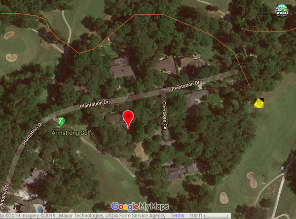
3353 Plantation Drive is not the spill location, Google Map
Red marker: 3353 Plantation Drive. Yellow diamond sign: actual spill location.

That entry included a more precise address than Valdosta had previously reported: 3353 Plantation Drive. Unfortunately, that address is still incorrect. As I have pointed out to GA-EPD, the spill was Continue reading

Valdosta sewage sign, golf course, Valdosta Country Club, Stillhouse Branch 2019-08-23

Friday we found the warning sign on the Valdosta Country Club green for the Wednesday force main sewage spill, thanks to Valdosta Utilities Environmental Manager Scott Fowler, who told me where it was. Sara Jay has tested downstream for WWALS, and maybe we can get the Valdosta water quality testing data, as well. Although there is some ambiguity as to which way downstream is.

[Sewage Spill]
Sewage Spill

“It stinks,” said a man on a golf cart on the green, as I was taking pictures. Continue reading

Valdosta Sewage spill into Stillhouse Branch, Withlacoochee River 2019-08-21

Credit for telling the public, but no credit for a very vague report, in the latest sewage spill in the City of Valdosta.

Every address on Plantation Drive is in the 3300 block, so that locates the spill only within 4,000 feet. Valdosta does know the name of that “local stream,” which is Stillhouse Branch, and where it goes, which is into the Withlacoochee River, upstream from US 41 and Langdale Park.

[Plantation Drive]
Plantation Drive

By “on a golf course” we can deduce the spill must have been Continue reading

Staten Road to Langdale Park, Withlacoochee River, 2018-03-03

A leisurely five mile paddle in about two and a half hours through a surprisingly wild section of the Withlacoochee River, much of it actually inside Valdosta, the biggest city in the Suwannee River Basin, on the Withlacoochee and Little River Water Trail (WLRWT).

When: 9 AM, Saturday, March 3, 2018

Put In: Staten Road Landing, 4556 Staten Road, Valdosta, GA 31605, Lowndes County, GA. 7.1 miles north of downtown Valdosta. Beware: it’s a long rough dirt road access, then a scramble down the riverbank.

GPS: 30.9328, -83.28227

Take Out: Langdale Park Boat Ramp, 3781 N. Valdosta Rd., Valdosta, GA 31602, Lowndes County, GA.

Free: This outing is Free! And we recommend you support the work of WWALS by becoming a WWALS member today!

Event: facebook, meetup

VALORGIS, Route
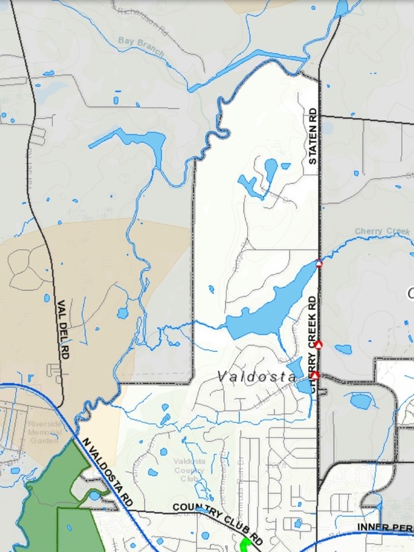
Map: VALORGIS. White is Valdosta inside grey city limits, yellow is recharge zones for the Floridan Aquifer, green is Langdale Park.

We start in Lowndes County, cross over the county’s expanded sewer and water lines at Bay Branch (those lines head for Stafford-Wright Road). Then the City of Valdosta is on our left briefly before back to county both sides, and Sermons Branch (is that its real name?). Into a Floridan Aquifer recharge zone, passing on our right the Shadrick Sink, notorious for Continue reading

Staten Road bridge to Langdale Park, Withlacoochee River through Valdosta 2016-03-20

Update 2016-03-24: Pictures.

Explore the Withlacoochee River as it meanders thru the edge of Valdosta, past Shadrick Sink, Cherry Creek, and under North Valdosta Road, Back along the bank on the Withlacoochee and Little River Water Trail. Wave at some of your friends in the houses nearby.
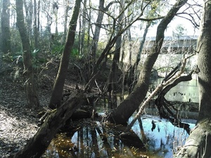
Update 2016-03-19: Yes, there are potholes at Staten Road Bridge, but that never stopped us from paddling. Come on down!

Update 2016-03-14: Langdale Park will be closed, but VLPRA will let us in.

Event: facebook or meetup.

When: 9AM Sunday March 20th 2016

Put in: Staten Road Bridge, 7.1 miles north of Valdosta, Lowndes County.

Take out: Langdale Park Boat Ramp, 3781 N. Valdosta Rd., Valdosta, GA 31602, Lowndes County.

Distance: About 5 miles

Duration: About 2.5 hours

Shuttle: About half an hour

Take out: Langdale Park Boat Ramp

Also passing: Bay Branch, Sermons Branch (if that is its real name), Withlacoochee Slough at Cherry Creek, Cherry Creek Sink, and Stillhouse Branch coming out of Valdosta Country Club.

Responsible party: Chris Mericle

Local host: John S. Quarterman

Directions from Valdosta: head north on Ashley Street, turn left on Oak Street Extension,

Directions from I-75: take exit 22, go east on North Valdosta Road, left on Perimeter Road, left on Oak Street, continue onto Staten Road, cross Orr Road, and after about 2/3 of a mile just before the bridge, turn off to the right.
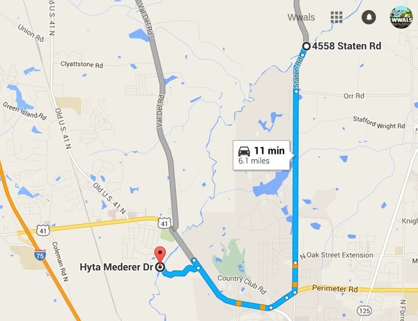
Map from Staten Road Bridge to Langdale Park Boat Ramp

Too low: we’re guessing 2 feet on either the at Skipper Bridge or US 41 gauges.

Too high: flood stage is 15 feet at Skipper Bridge and at US 41.

This outing is Free! But we encourage you to join WWALS today to support our fun outings and important work: /donations/. See our newsletters, and the press Releases and news. And consider joining the Withlacoochee and Little River Water Trail Committee.

Backup in case of low or high water:

Where: Ray’s Millpond

When: 9AM March 20th 2016

Directions: From Valdosta, north on Bemis Road (GA 125) to Ray City, right on Jones St. to boat ramp.

Coming up even sooner:

For more outings and events as they are posted, see the WWALS calendar.

-jsq

You can join this fun and work by becoming a WWALS member today!