Tag Archives: Sermons Branch

Alapaha, Withlacoochee Rivers, Lowndes County Commission 2021-08-10

For voting Tuesday evening, three water-related items have more implications than might appear from the agenda of the Lowndes County Commission.

[Lake Alapaha water treatment, Bay Branch tributaries in Building Valdosta Subdivision, Army Corps on Val Del Villas]
Lake Alapaha water treatment, Bay Branch tributaries in Building Valdosta Subdivision, Army Corps on Val Del Villas

7.a. REZ-2021-09 Building Valdosta Subdivision (0070 018), R-A to R-21, Community Well & Septic, ~64.84 acres.

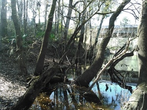
This subdivision has two creeks crossing it, leading to Bay Branch and the Withlacoochee River, plus at least one retention pond.

7.c. REZ-2021-13 Val Del Villas, Val Del Rd. P-D Amendment, County Water and Sewer, ~28.436 acres

For this existing subdivision, Northside Property Development wants to add more houses. It got the U.S. Army Corps of Engineers to determine that the remaining part of Val Del Villas off Val Del Road is not jurisdictional wetlands. That’s uphill from Sermons Branch and the Withlacoochee River. Northside Property Development has the same registered agent as Uvalde Land Company that bought the Cherry Creek Mitigation Bank next to the other side of the Withlacoochee River, and wants to deannex the upland half of it from Valdosta. The uplands in that Bank tract are not jurisdictional wetlands, either.

8.b. Alapaha Plantation Water Treatment Pilot Study

This is the kind of extra expense Valdosta avoided by sinking its water wells at Guest Road twice as deep after Withlacoochee River water was discovered reaching them from Shadrick Sink, on the other side of the Withlacoochee River, and the other side of what is now the Cherry Creek Mitigation Bank, recently sold to Uvalde Land Company, which wants to deannex half of it from Valdosta.

For much more background, including the so-far $225,415 running total for Lowndes County subsidizing water for the private Lake Alapaha subdivision next to the Alapaha River, see The never-ending Lake Alapaha Water Treatment Plant saga @ LCC 2021-08-10.

 -jsq, John S. Quarterman, Suwannee RIVERKEEPER®

You can join this fun and work by becoming a WWALS member today!

Staten Road bridge to Langdale Park, Withlacoochee River through Valdosta 2016-03-20

Update 2016-03-24: Pictures.

Explore the Withlacoochee River as it meanders thru the edge of Valdosta, past Shadrick Sink, Cherry Creek, and under North Valdosta Road, Back along the bank on the Withlacoochee and Little River Water Trail. Wave at some of your friends in the houses nearby.

Update 2016-03-19: Yes, there are potholes at Staten Road Bridge, but that never stopped us from paddling. Come on down!

Update 2016-03-14: Langdale Park will be closed, but VLPRA will let us in.

Event: facebook or meetup.

When: 9AM Sunday March 20th 2016

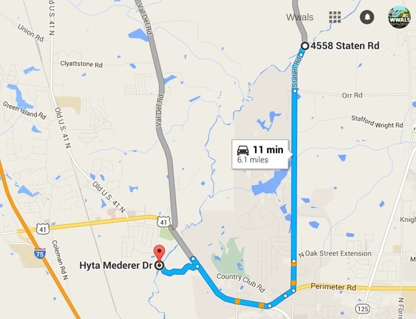
Put in: Staten Road Bridge, 7.1 miles north of Valdosta, Lowndes County.

Take out: Langdale Park Boat Ramp, 3781 N. Valdosta Rd., Valdosta, GA 31602, Lowndes County.

Distance: About 5 miles

Duration: About 2.5 hours

Shuttle: About half an hour

Take out: Langdale Park Boat Ramp

Also passing: Bay Branch, Sermons Branch (if that is its real name), Withlacoochee Slough at Cherry Creek, Cherry Creek Sink, and Stillhouse Branch coming out of Valdosta Country Club.

Responsible party: Chris Mericle

Local host: John S. Quarterman

Directions from Valdosta: head north on Ashley Street, turn left on Oak Street Extension,

Directions from I-75: take exit 22, go east on North Valdosta Road, left on Perimeter Road, left on Oak Street, continue onto Staten Road, cross Orr Road, and after about 2/3 of a mile just before the bridge, turn off to the right.

Map from Staten Road Bridge to Langdale Park Boat Ramp

Too low: we’re guessing 2 feet on either the at Skipper Bridge or US 41 gauges.

Too high: flood stage is 15 feet at Skipper Bridge and at US 41.

This outing is Free! But we encourage you to join WWALS today to support our fun outings and important work: /donations/. See our newsletters, and the press Releases and news. And consider joining the Withlacoochee and Little River Water Trail Committee.

Backup in case of low or high water:

Where: Ray’s Millpond

When: 9AM March 20th 2016

Directions: From Valdosta, north on Bemis Road (GA 125) to Ray City, right on Jones St. to boat ramp.

Coming up even sooner:

For more outings and events as they are posted, see the WWALS calendar.

-jsq

You can join this fun and work by becoming a WWALS member today!