Update 2017-03-10: PDF of burning and water well drilling violation complaint sent to FERC, USACE, GA-EPD, and GFC.
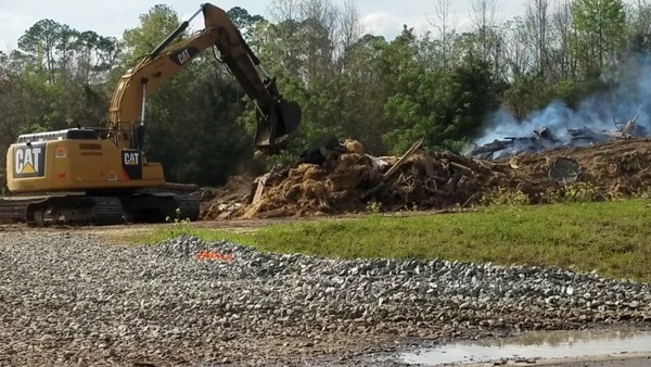
Bringing materials from another site to burn is illegal in Georgia, even if they had a permit, which they didn’t, it couldn’t cover open burning of treated ties like Sabal Trail is doing at the Brooks County Industrial Park south of Quitman, Georgia. Georgia Forestry Commission is already on it, and I’m alerting FERC, USACE, GA-EPD, and Brooks County today. The entire Troy yard is right next to a wetland, with three drainage ditches crossing the site.
There’s nothing going on at the Withlacoochee River HDD site in Lowndes County, but they’re shuffling pipe on a Texas Troy truck between Gary Lane Knights Ferry Road, right past a Lowndes County School bus on McGoggle Road.
And why is there Texas well drilling equipment on Knights Ferry Road?
Below are more pictures and a google map showing where I took the picture. Thanks to WWALS member John Horton for noticing the burning and calling Suwannee Riverkeeper and Georgia Forestry Commission.
-jsq, John S. Quarterman, Suwannee RIVERKEEPER®
You can join this fun and work by becoming a WWALS member today!
Pictures

Troy Access, Brooks County Industrial Park, GA 333, 30.7676560, -83.5602633

Railroad Crossing, Fritzke Drive, 30.7682057, -83.5569752

Pipeline Construction Ahead 30.7685866, -83.5554520

Troy Access, Prospect Dr & Venture Dr, 30.7687042, -83.5546071

Movie: Troy Construction Quitman, GA Facility (176M) 30.7640300, -83.5544160

Gateway Dr. @ GA 333, 30.7599539, -83.5542605

Many white trucks, Foreman Office Only 30.7605747, -83.5529692

Porta-potties, 30.7605747, -83.5529692

Construction equipment and porta-potties, 30.7605747, -83.5529692

More equipment, 30.7630956, -83.5532981

Still more equipment and trucks, 30.7605747, -83.5529692

Portable buildings, 30.7608446, -83.5527042

Fire hydrant, 30.7608446, -83.5527042

ModSpace, 30.7608446, -83.5527042

Electrical connection, 30.7608446, -83.5527042

Smoke visible, 30.7611525, -83.5526951

Storm gutter, 30.7611525, -83.5526951

Sabal Trail along Venture Dr from Gateway Dr, 30.7610119, -83.5523276

Fire hydrant and MV concrete markers, 30.7611525, -83.5526951

Smoky cross 30.7610119, -83.5523276

MV marker on Gateway Dr, smoke behind, 30.7611163, -83.5521486

Houston, TX Troy truck sucking water from fire hydrant 30.7622148, -83.5505297

5000 GAL. WATER TRUCK, Houston, Texas, US DOT 488929, TROY, 30.7619444, -83.5502778

Fire hydrant with Tory hose, 30.7622222, -83.5502778

No Trespassing on publicly-owned land, 30.7618355, -83.5522531

Red plastic sticks, 30.7607951, -83.5532621

Troy shipping containers, 30.7620317, -83.5525043

Piles of poles, 30.7621666, -83.5527104

South drainage ditch, 30.7621666, -83.5527104

Ark Field Services and empty spools, 30.7621666, -83.5527104

Black bags, 30.7624537, -83.5529746

White plastic, green equipment, fire hydrant, porta-pottie, 152256 30.7625581, -83.5529997

Employee Parking, 30.7627302, -83.5531115

No Trespassing, 30.7627302, -83.5531115

More white plastic, 30.7627302, -83.5531115

Many CATs, 30.7630956, -83.5532981

Middle drainage ditch, 30.7632904, -83.5534171

Green light pole, 30.7632904, -83.5534171

Black FX4 truck, 30.7635927, -83.5534758

Car and porta-pottie, 30.7638145, -83.5534514

Dumpsters, 30.7638145, -83.5534514

Another black truck, 30.7642763, -83.5534618

TROY CONSTRUCTION, HOUSTON, TEXAS, and PVC pipes, 30.7642763, -83.5534618

North drainage ditch, 30.7644530, -83.5534752

Black bags of white, 30.7644530, -83.5534752

Racks, 30.7648735, -83.5535462

Ties, 30.7650998, -83.5535024

Racked ties, 30.7650998, -83.5535024

Black truck, burn pile, Cat, 30.7653789, -83.5535715

Movie: Cat stacking burn pile (154M), 30.7653789, -83.5535715

Cat dropping tie on pile, 30.7657241, -83.5535577

Movie: Burn piles and ties (71M) 30.7657476, -83.5535967

Movie: More cat grubbing (46M) 30.7657476, -83.5535967

Movie: Cat pick up sticks (53M) 30.7657476, -83.5535967

Plastic lids on burn pile, 30.7658333, -83.5536111

Ties, lids, hay bales, black and white plastic on burn pile, 30.7658573, -83.5536063

Not natural tree limbs, 30.7658333, -83.5533333

Movie: Closeup black and white plastic, lids, ties on burn stack (42M) 30.7658333, -83.5533333

Movie: Cat sets tie on top of burn pile (64M) 30.7658333, -83.5533333

Cat picks up tie 30.7658333, -83.5533333

Carries tie 30.7658333, -83.5533333

Tie above pile 30.7658333, -83.5533333

Tie drops on pile 30.7658333, -83.5533333

Sabal Trail cross at creek, 30.7673541, -83.5539386

Sabal Trail smoky cross, 30.7674166, -83.5540214

Georgia Forestry Commission Fire Control, 30.7680006, -83.5540245

Ark Engineering, 30.7679955, -83.5540283

Ark Engineering again, 30.7679955, -83.5540283

White and black trucks on Fritzke Dr/Prospect Dr, 30.7679894, -83.5540289

HDD site, Martin Way, Lowndes County, GA, 30.7680692, -83.5585139

Berm, 30.7875867, -83.4453779

RoW marker, 30.7875867, -83.4453779

Drill site, 30.7875867, -83.4453779

Looking south, 30.7875867, -83.4453779

Looking west, 30.7875867, -83.4453779

Tiger Creek downstream, Ousley Road, 30.7895789, -83.4278216

Tiger Creek upstream, Ousley Road, 30.7896038, -83.4277546

Porta-pottie, Sabal Trail, e. of Ousley Road, 30.7684106, -83.4193169

Sabal Trail crossing Ousley Road, looking north, 30.7679320, -83.4191102

Tire, Sabal Trail, Porta-pottie, e. of Ouslie Road 30.7684033, -83.4192375

Tires, trash, Sabal Trail, w. of Ouslie Road, 30.7684843, -83.4192938

Movie: Sabal Trail w of Ouslie Road (13M) 30.7684843, -83.4192938

Troy Rental, Rush Crane Systems, Gary Lane, 30.7635044, -83.4124942

Pipe truck, Gary Lane, 30.7635044, -83.4124942

Obscured R17-1379 Lone Star State license plate, pipe truck, 30.7635044, -83.4124942

Green and red pipe, TROY, Houston, Texas, US DOT 488929, 30.7635044, -83.4124942

Movie: Green and red pipe on Troy truck, Gary Lane (97M) 30.7652375, -83.4158111

Troy pipe truck on Gary Lane, 30.7652375, -83.4158111

Texas 64-344, not same plate as front of Troy pipe truck, 30.7655556, -83.4166667

Gary Lane at Ouslie Road, 30.7651169, -83.4174465

Troy pipe truck turning onto Knights Ferry Road, 30.7436221, -83.4111960

Troy pipe truck, obscured consruction sign, black truck, Knights Ferry Road, 30.7463889, -83.4075000

Lowndes County School Bus, McGoggle Road, Troy Access, Troy pipe truck, 30.7484302, -83.4029359

Lowndes County School Bus, Troy pipe truck, 30.7484951, -83.4027487

Troy pipe truck turning into Sabal Trail on Knights Ferry Road at McGoggle Road, 30.7484390, -83.4021310

Movie: TOPSOIL, Troy Access, porta-pottie, s. of Knights Ferry Road (18M) 30.7483333, -83.4016667

Sabal Trail digging south of Knights Ferry Road, 30.7483333, -83.4016667

Troy pipe truck north of Knights Ferry Road, 30.7483333, -83.4016667

Movie: Pipe swinging, Troy truck approaching (218M) 30.7489660, -83.4014340

Pipe in air, 30.7483943, -83.4018203

Pipe in air next to pipe truck, 30.7483333, -83.4016667

Movie: Set pipe on ground instead of on Troy truck (370M), 30.7483943, -83.4018203

Well drilling equipment, Knights Ferry Road, 30.7485032, -83.4017858

Andrews & Foster, Athens, Texas, US DOT 2095262, 30.7485032, -83.4017858

Looks like vertical water well drilling equipment, 30.7485032, -83.4017858
Google Map
Follow this link for the interactive google map, or it’s also embedded below.
Short Link:


