
Yellow Dog selling kayak raffle tickets

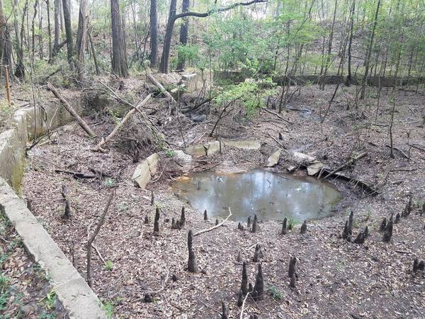
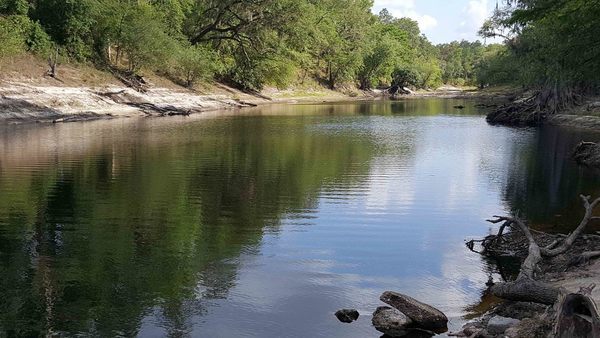
Local cave diver Aaron Sirmons took these pictures and videos of the formerly famous Wade Springs of Brooks County, Georgia, between Blue Springs Road and the railroad, west of the Withlacoochee River. He has a letter of permission from the landowner.
Salt water intrusion inland is worse than you think, including the “Apalachicola salinity feature” up to the GA-FL line and east through Lowndes County, with a special additional brackish Valdosta feature. Central north Florida is an island of fresh groundwater surrounded by entire saline Florida coast around from Alabama plus across to Brunswick, GA, then again from Savannah up past Charleston. South of Lakeland, FL the map is all red for saline.
Apparently using the data preliminarily mapped earlier in the Florida Well Salinity Study, geologists from three states connected the dots in Revised Hydrogeologic Framework of the Floridan Aquifer System in Florida and Parts of Georgia, Alabama, and South Carolina, By Continue reading
These aerial photographs by Beth Gammie cover the route of the Saturady 20 May 2017 WWALS Outing down the Suwannee River from Woods Ferry Tract Launch to Suwannee Springs. She took them for WWALS 23 November 2016, on a Southwings flight piloted by Roy Zimmer. They’re all looking from Hamilton County south (or west) across the Suwannee River into Suwannee County.
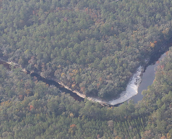
I have pulled out a few detail shots, of Woods Ferry Tract Launch and of Suwannee Springs.
Update 2023-04-13: Pictures.
Due to low water, we’re moving the May 20th outing downstream! With lunch, swim stops, and bon-bons, of course. Bring bug spray and the usual personal flotation device, boat paddles, food, drinking water, warm clothes, and first aid kit. If you don’t have a boat, there are many outfitters, or let us know and many of us have spare boats.
Two outfitters advise there should be enough water on this route to avoid much boat dragging. There is a slight 30% possibility of afternoon thunder showers. Same date, same time, same river: just a bit downstream.
When:
9AM Saturday May 20, 2017, meet to shuttle
10AM: Start paddling
12PM noon: Stop for Hands Across the Sand
“Say NO to dirty fuels and YES to clean energy”
2-3PM: Finish some time around then
Put In: Mile 158.0, Woods Ferry Tract Launch, in Suwannee County, Florida
GPS of Entrance: to Woods Ferry Tract 30.343508, -82.855187
Paddle Distance: 8.0 river miles
Paddle Duration: 4 hours
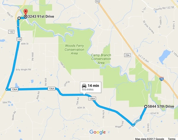
Directions to Put In: From Live Oak, travel north on Continue reading
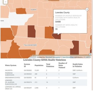
Congratulations City of Valdosta! You got the VDT to issue a correction for that one sentence a week ago, even though the VDT blamed it on “a source cited in the article”, and came up with yet another number of violations that doesn’t match what NRDC says nor what Valdosta says, with still no specific comparisons to other local governments. So it’s a correction that doesn’t resolve anything. And you’re not helping your credibility problem, Valdosta, by quibbling over a single digit while neglecting to mention an entire year in which you did have drinking water violations that match what’s in NRDC’s map.
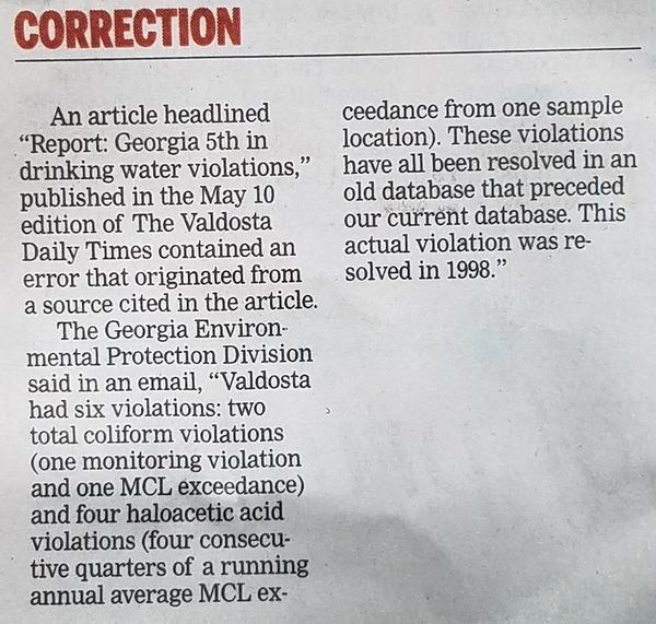
Valdosta Daily Times, page 3A, 17 May 2017
CORRECTION
An article headlined “Report. Georgia 5th in drinking water violations,” published 1n the May 10 edition of The Valdosta Daily Times contained an error that originated from a source cited in the article.
The Georgia Environmental Protection Division said in an email, “Valdosta had six violations: two total coliform violations (one monitoring violation and one MCL exceedance) and four haloacetic acid violations (four consecutive quarters of a running annual average MCL exceedance from one sample location). These violations have all been resolved in an old database that preceded our current database. This actual violation was resolved in 1998.”
This correction is on page 3A, below the Crime Report. It does have a big red CORRECTION header, but Continue reading
With reference Yellow Dog.
Taken from Tyler Bridge on river mile 78.71 at Franklinville Road.
-jsq, John S. Quarterman, Suwannee RIVERKEEPER®
You can join this fun and work by becoming a WWALS member today!
Please call your U.S. Senators today and ask them to oppose Senate Bill 951, the so-called Regulatory Accountability Act, which would actually obstruct enforcing regulations that protect our clean air and water. As Suwannee Riverkeeper among 121 U.S. Waterkeeper Members and Affiliates told the EPA yesterday, we need stronger protections against coal ash, unnecessary pipelines, and fracking, not less. Solar and wind power already employ more people than coal, oil, and gas combined, so there’s no economic reason to let the failing fossil fuel industry crimp our regulatory system like this, and every reason of drinking water, industry, recreation, and wildlife to keep it clean.
That’s 202-224-3121
Georgia: David Perdue and Johnny Isakson
Florida: Bill Nelson and Marco Rubio
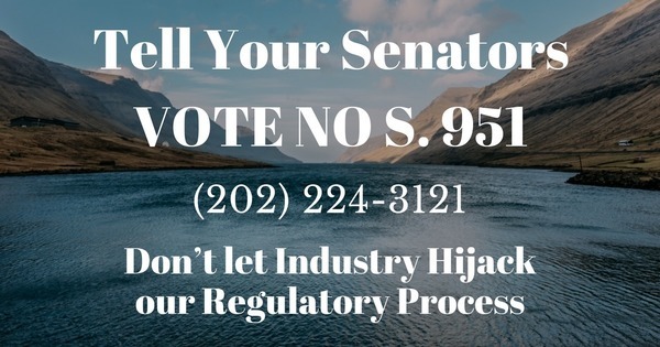
Larissa Liebmann, Waterkeeper Alliance, 15 May 2017, Don’t let Industry Hijack our Regulatory Process! Continue reading
Update 2017-05-17: OK, the water’s gotten too low at the original location, so we’re moving downstream to Woods Ferry Tract Launch to Suwannee Springs.
Hands Across the Sand on the Suwannee Saturday! The river is quite low (48.78 feet NAVD on the White Springs gage), but it looks doable from the put-in and take-out. A ranger at Stephen Foster State Park told me paddling from White Springs to Swift Creek would be doable, perhaps with a few dry spots. I’ll also call a local outfitter or two for their opinions.
Meanwhile, bring bug spray (gnats) and a rope (to pull your boat over sand bars), and we’re still on for 9AM Saturday 20 May 2017. See the outing announcement for more details.
Plus: that’s the day of Hands Across the Sand, “Say NO to dirty fuels and YES to clean energy”. WWALS has been saying that for years, so somewhere on the Suwannee we will stop and do Hands Across the Sand against the Sabal Trail fracked methane pipeline and for solar power.
The VDT and the City of Valdosta are feuding again about water quality,
this time about drinking water (not sewage).
 They’re both wrong and both right, and neither named
any of the other poor local water sources.
The VDT didn’t make this story easy to follow by omitting the key piece
from its first online story and not quoting its source,
and the city didn’t acknowledge some main points the VDT made.
They’re both wrong and both right, and neither named
any of the other poor local water sources.
The VDT didn’t make this story easy to follow by omitting the key piece
from its first online story and not quoting its source,
and the city didn’t acknowledge some main points the VDT made.
Kimberly Cannon, Valdosta Daily Times, 10 May 2017, City celebrates water: Mayor refutes water quality report, Continue reading

