
Second of a series of posts from Dr. Ken Sulak, USGS, retired. He is aware that Indian Trailmarker Trees are still speculative. Maybe with enough examples we can all determine whether they are what they seem to be. Please send pictures and locations of any trailmarker trees you may have seen, especially along old trails that crossed the Alapaha, Withlacoochee, Little, Suwannee, or Santa Fe Rivers, such as Old Coffee Road or various versions of El Camino Real.
![[Old Trails]](https://www.wwals.net/pictures/2020-11-02--trail-marker-trees/trails.jpg)
Thanks for your reply. The trailmarker tree thing is an offshoot of my research on historic settler fords, ferries and bridges. Certainly early settlers traded with Seminoles and followed their trails. This Motte map is one of the few I have encountered that shows trails from GA coming into FL. There has also been more published on the ‘Alachua Trail’ figured in the next map. But that is of less interest to me because folks using that trail were primarily headed to the St. Johns River area—a distinct migration thing from the GA and SC folks headed for ‘Middle Florida’ where the best farm land and ample water was available.
I have been trying to confine my studies and field explorations to that area—but have inevitably gotten involved with what was happening in S GA. I have made several foot and solo kayak trips to the GA/FL border, and up into GA a bit now.
Many coming south from GA crossed into Spanish FL at Warners (Beauforts, Hornes) Ferry over the Withlacoochee, then headed south to Deadman’s Bay (Steinhatchee) to boil down salt water to make several barrels full of salt to take back to GA in wagons. This is one of the several ‘Old Salt Trails’ that later immigrant settlers used. All six of the so-far discovered trailmarker trees fall right on one of the dotted trails in this map
![[1838 Motte Seminole War trail map]](https://www.wwals.net/pictures/2020-11-02--trail-marker-trees/1838-motte-seminole-war-trail-map.jpg)
Motte’s 1838 Seminole War map showing trails with dotted lines.
Warners Ferry or Horn’s Ferry was near where the current Horn Bridge is over the Withlacoochee River just upstream of State Line Boat Ramp and the GA-FL line.
I asked Ken a few questions, including:
By the Trailmarker Tree Project do you mean The Trail Tree Project?
https://www.mountainstewards.org/project/internal_index.html
He agreed it is.
I wondered:
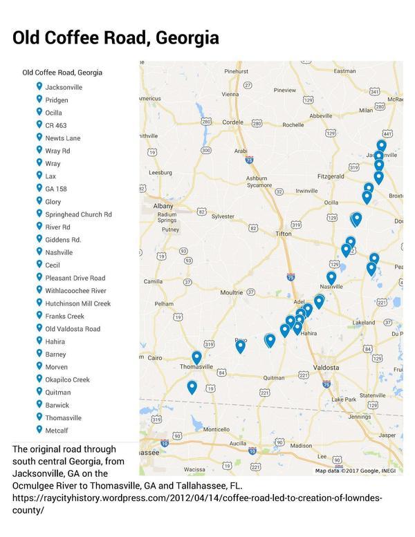
There’s also the Old Coffee Road, which went from Jacksonville, GA on the Ocmulgee River through Thomasville to Tallahassee. While that was a settler road, I wouldn’t be surprised if it followed Indian trails where-ever it could.
https://wwals.net/2017/09/03/old-coffee-road-georgia/
Follow
this link for the interactive google map.
Ken answered:
That Thomasville to Tallahassee section matches up with another ‘Old Salt Trail’.
Further I wondered:
Similarly, there must have been tracks to the old Spanish missions, which themselves were probably established on Indian trails. One of those was where the parking lot for the Georgia Welcome Center now is on I-75, so there was probably a trail coming up the divide I-75 follows.
Ken answered:
Motte’s map shows the original Lower Mission Road (El Camino Real) from St Augustine (Ft Marion) heading west to Tallahassee, and also the later Upper Mission Road from Jacksonville to Tallahassee and beyond. The upper trail (aka Stagecoach Road) provided the track for US 90 and then I-10. The Lower Trail was the track for Bellamy Road. There were additional N-S ‘Old Spanish Trails’, such as one from Tallahassee to the important trading post and port of St. Marks, and another along the west bank of the lower Suwannee River. All of these Spanish Trails reportedly followed earlier Indian trails.
And I wondered:
Plenty of other likely locations at or leading to fords of rivers.
Ken provided further detail:
There were 3 early surveys of the Suwannee River by a Captain Black, then Col. Robert E Lee in the 1830s, then US Army Corps of Engineers by Capt Slattery in 1912. The survey maps of Black and Lee cannot be located in the US National Archives – supposed to be there but apparently lost.
Univ Florida has a 3-sheet large format copy of the Slattery survey, Fargo to river mouth. All the existing bridges and ferries are marked, also each mile has a mark, and about each third of a mile the mid-river depth. This is very useful to show the shallow places where a ford was possible – and at least three have proven out, matching with early settler crossing points.
That would be Captain J.R. Slattery:
2043. Map Description: Suwannee River, Florida. (3 sheets)
Map Author: Slattery, J.R., Capt.
Map Number: M3.1912.001.2010.0455
Map Year: 1912
Map Link: N/A
Florida Historical Map Database
Unfortunately, there seem to be no images of that three-sheet 1912 survey online.
For why trailmarker trees seem plausible, stay tuned.
Meanwhile, have you seen any likely trailmarker trees, especially along any of these old trails?
-jsq, John S. Quarterman, Suwannee RIVERKEEPER®
You can join this fun and work by becoming a WWALS member today!
Short Link: