
 The day of action against Sabal Trail at the Suwannee River
saw hundreds turn out on land, water, and in the air and
got a lot of press, but Sabal Trail continued to pound pipe
into the ground in Hamilton County, Florida, going under Suwannee River State Park (SRSP) and the Suwannee River.
The day of action against Sabal Trail at the Suwannee River
saw hundreds turn out on land, water, and in the air and
got a lot of press, but Sabal Trail continued to pound pipe
into the ground in Hamilton County, Florida, going under Suwannee River State Park (SRSP) and the Suwannee River.
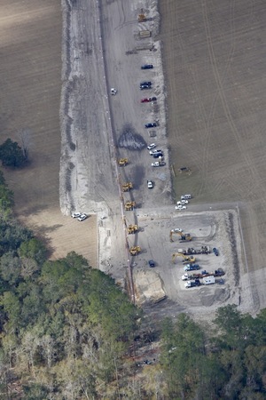
On the WWALS website are photographs by Beth Gammie for WWALS from a Southwings flight piloted by Roy Zimmer, navigated by Can Denizman, January 14, 2017. You may reuse these pictures provided you cite the source: Beth Gammie for WWALS Watershed Coalition.
For where they were taken, see the WWALS Google Map.
Lynn Buchanan posted a facebook video taken from the woods of Suwannee River State Park.
Panorama, Sabal Trail pipe going into ground, Hamilton County, 30.4113889, -83.1652778
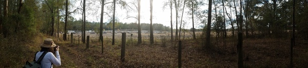
This picture: by John S. Quarterman for WWALS at 4:43 PM from SRSP.
Note the 15 Florida Highway Patrol cars, where in the pictures below by Beth Gammie from the air a few hours earlier there were only a few Hamilton County Sheriff vehicles.
Google Map
Follow this link for the google map, and it’s embedded below.
-jsq, John S. Quarterman, Suwannee RIVERKEEPER®
You can join this fun and work by becoming a WWALS member today!
Short Link:
Pingback: Quarterman: Sabal Trail pipeline already damaging our area | WWALS Watershed Coalition (Suwannee RIVERKEEPER®)