Category Archives: River

Non-answers in Sabal Trail Biweekly Status Report 2016-11-04

If drilling mud may be released, how can this also be? “No wastewater has been or will be dumped into the Withlacoochee River.” Sabal Trail seems to have contradicted itself. Sabal Trail responses to WWALS questions 
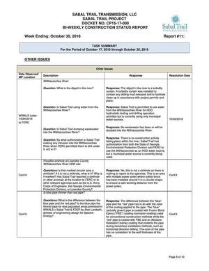
And didn’t answer the permit questions from WWALS. Nonetheless all their responses are marked “Resolution Date: 10/30/2016”. Nope, not resolved, Sabal Trail. See new questions.

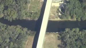
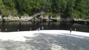
Sabal Trail also said (see the PDF) it was completing drilling under the Flint River, was drilling under the Ochlockonee and Withlacoochee Rivers in Georgia, had just started under the Santa Fe River, was doing clearing and pad preparation for the Chattahoochee and Suwannee Rivers, and hadn’t yet started anything at the Withlacoochee (south) River in Florida. Plus quite a few complaints and questions, including some from FERC, and some archaeological discoveries which Sabal Trail and FERC hid under “Privileged and Confidential information”.

The Sabal Trail responses labeled Continue reading

WWALS at Alapaha Station Celebration 2016-11-12

WWALS be talking about how Alapaha RIver Water Trail, which starts at Sheboggy Landing on US 82 just east of Alapaha, GA, at the Alapaha Station Celebration. This the third year for WWALS at this festival located in the upper middle section of our watershed near the Willacoochee and Alapaha Rivers.

When: 9AM-5PM Saturday November 12th 2016

Where: 245 NE Railroad St, Alapaha, GA 31622

Events: facebook, meetup.

Some people wonder: what’s the station? It’s Continue reading

CY3-6 full less than a day after FERC approval: Sabal Trail Moultrie contractor yard 2016-10-22

Less than a day after FERC rubberstamped (or did it?) Sabal Trail’s request for a new contractor yard on the east side of Moultrie, Georgia, WWALS saw that yard already full of materials. Did Sabal Trail really move everything in that fast, or were those things already there, like the notorious Lake City, Florida pipe yard that never has gotten any formal FERC approval that we’ve seen?

Here’s what we saw from the Southwings flight for WWALS on Saturday October 22nd 2016:

CY3-6 area of Sabal Trail overview map

Compare with the overview map Sabal Trail filed with its request to FERC of Monday October 17th 2016: Continue reading

Cancer in Waycross and the upper Suwannee River watershed

At least the Waycross cancer problem is finally getting some news media attention. Brenda Goodman and Andy Miller, Georgia Health News, October 20, 2016, Why are kids in Waycross getting cancer? (Part One of Special Report),

Fourteen-year-old Lexi Crawford was attacked by lower back pain so sharp that she couldn’t even sit up to eat. Her mother had to bring her food while she was lying flat on her back. Doctors in Waycross, GA, the town where she lives, thought it was a kidney infection. But after months of antibiotics didn’t clear it up, a visiting doctor in the local ER suggested an X-ray.

What he saw on the scan was terrifying.

Continue reading

Aerials: Suwannee, Ocholockonee, Withlacoochee, Santa Fe Rivers, Okapilco Creek, Sabal Trail Moultrie CY3-6 @ WWALS Southwings 2016-10-22

Update 2016-11-07: You can put your own pictures on a related google map.

Digging under I-10 with traffic on it, 30.3512070, -83.1606820 From the air what you can’t see from the ground: Sabal Trail through north Florida and south Georgia.

Driving down I-10, you wouldn’t know Sabal Trail was digging underneath you,g for example.

Digging under I-10 with traffic on it,

On Saturday October 22nd 2016, Southwings flew WWALS over more than 100 miles of the Sabal Trail route: Continue reading

WWALS and children at Trunk or Treat at Reed Bingham State Park 2016-10-29

Girl Scouts helping Girl Scouts were a big part of our success today! Boy Scouts wanted to know if we had Eagle Scout projects: yes, we do! Thank you to our new friends.

People wanted to know about outings, advocacy, pipeline, and since Reed Bingham is on the Little River, I gave out all the pamphlets for the Withlacoochee and Little River Water Trail I had printed. An excellent time was had by WWALS and all at the Reed Bingham Trunk or Treat Fall Festival.

Gretchen

You can join this fun and work by becoming a WWALS member today!

Continue reading

WWALS at Reed Bingham Fall Festival 2016-10-29

The wizard is in

Update 2016-10-30: Pictures and scouts.

WWALS will have a bean bag game at Reed Bingham State Park this Saturday. You may not be too old to win some candy! Come join us on the banks of the Little River, between Adel and Moultrie, Georgia.

When: 1-5PM Saturday October 29th 2016

Where: Reed Bingham State Park, 542 Reed Bingham Rd, Adel, GA 31620

Handshake Facebook: event

Moultrie Observer, 26 October 2016, Reed Bingham to host Fall Festival, Halloween events,

All participants should give out individually wrapped candies or promotional items appropriate to families. Friends of Reed Bingham will give a prize for the best decorated “Trunk”

For more information or Continue reading

Mozell Spells, Horn Bridge, GA-FL line, Withlacoochee River 2016-10-22

Movie: Horn Bridge, Mozell Spells, Withlacoochee River, GA-FL line (227K) Pictures and a movie clip from the air (thanks, Southwings!) of Mozell Spells, aka Madison Highway Boat Ramp, State Line Ramp (GA DNR) or GA 31 Ramp (SRWMD) or CR 145 Bridge Launch (FDEP).

This is one of two dozen public landings on the Withlacoochee and Little River Water Trail (WLRWT). It’s at the Georgia-Florida state line, and in the big picture (scroll down) you can see Continue reading

Sabal Trail between SRSP and I-10 in Suwannee County, FL 2016-10-16

Signs and pipe, 30.3918 -83.152922 Does Sabal Trail think black bears can’t walk the short distance from 24th Street, Stagecoach Road, and US 90 to 199th Place? What about those fox squirrels and indigo snakes? Gopher tortoises are also more places than people might think.

And what about that sinkhole only about 200 feet from the pipeline at Pilgrim’s Pride on US 90? These two pictures were taken from the same place, looking in opposite directions:

w. to Sabal Trail, less than 200 feet from sinkhole, 30.3721680, -83.1550210 e. to huge sinkhole just s. of US 90 e. of Pilgrims Pride, 30.3720440, -83.1548290

Here are the pictures, from north to south. I actually started on Continue reading

Suwannee River Beach @ Spirit of Suwannee Music Park 2016-10-16

Stairs 30.4059372, -82.9478073 Very dry, and this was a week ago Sunday, with a bit more than 23 feet on the Nobles Ferry USGS gage. Surprisingly, the water’s not much lower now according to that gage.

Somebody asked us at Suwannee River Roots Revival: why is the Suwannee River so low? He was from the Atlantic coast of Florida, where they just had hurricanes, and didn’t realize: none of that rain fell upstream inland in Florida and Georgia up to the Okefenokee Swamp.

-jsq

You can join this fun and work by becoming a WWALS member today!

Continue reading