
On a motion (by Don Quincey) seconded (I think by Virginia Sanchez), with only one dissenting vote (Richard Schwab), the SRWMD board voted to table the Seven Springs permit application for six months, because they want Nestlé to be a co-applicant.
They do not want the permit to go back to DOAH; they want it to come back to SRWMD.
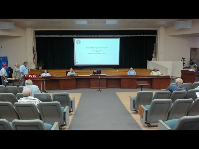
![[SRWMD Board and Nestle (Seven Springs) permit map]](https://www.wwals.net/pictures/2020-08-11--WWALS-to-SRWMD-no-Nestle/srwmd-board-nestle.jpg)
SRWMD Board and Nestle (Seven Springs) permit map
SRWMD Governing Board, l-r,
Donald J. Quincey, Jr. Vice Chair; Virginia Sanchez; Richard Schwab, Treasurer (voted nay); Gary F. Jones; Charles Keith; Virginia H. Johns, Chair.
Before they voted, they discussed that they were not in any way disparaging the efforts of SRWMD staff. The lack of Nestlé as co-applicant was the primary reason. A secondary reason was the lack of transparency. For example, there had been no public hearing, and while there were supposedly hundreds of people listening, nobody could see them.
Speaking of transparency, I had to ask to find out who made the motion, who seconded, and who voted nay. Fortunately, the staffer taking names during the fifteen minute recess for people to have sign up for public comment knew 2 out of 3. It’s not a very transparent process when the public doesn’t know who did what. Somebody else also asked could each SRWMD board member say who they were, or maybe the chair could.
Plus, the point of the WWALS letter to SRWMD this morning remains: without a SRWMD board member for the Santa Fe River, approval of this permit would be taxation without representation.
It is odd that Nestlé is not already a co-applicant, since in the board packet for today’s meeting there are 12 pages of Nestlé documents, starting with NWNA Water Consumption Estimates. Continue reading
![[WWALS to SRWMD: no water taxation without representation]](https://www.wwals.net/pictures/2020-08-11--WWALS-to-SRWMD-no-Nestle/2020-08-11--WWALS-to-SRWMD-no-Nestle-0001.jpg)
![[Figure 4.2 -- High SPrings Buildout Space Allocation]](https://www.wwals.net/pictures/2020-08-11--srwmd-board/2020-08-11--srwmd-board-packet-0121.jpg)
![[Seven Springs Water Company Project, 2-041-218202-3, August 2020]](https://www.wwals.net/pictures/2020-08-11--srwmd-board/2020-08-11--srwmd-board-packet-0110.jpg)
![[Trucks Entering Roadway, 12:12:12, 30.4796780, -83.2201059]](https://www.wwals.net/pictures/2020-07-29--state-line-madison-utilities-blue-spring-stt-pot-spring/20200729_121212.jpg)
![[Vehicular Traffic Prohibited, 12:15:03, 30.4795594, -83.2204892]](https://www.wwals.net/pictures/2020-07-29--state-line-madison-utilities-blue-spring-stt-pot-spring/20200729_121503.jpg)
![[Four views of Suwannee Springs]](https://www.wwals.net/pictures/2020-07-22--srwmd-suwannee-springs/quad.jpg)
![[Pot Spring on WWALS WLRWT map]](https://www.wwals.net/pictures/2020-07-20--pot-springs-closed/map-pot-spring.jpg)
![[Closed sign]](https://www.wwals.net/pictures/2020-07-20--pot-springs-closed/115909643_3653143638034289_8538882332407289173_o.jpg)
![[Alapaha CE (Bearden) Property Offer, Springs Protection]](https://www.wwals.net/pictures/2020-07-14--srwmd-board/2020-07-14--srwmd-packet-0044.jpg)
![[Three Vacant Board Slots]](https://www.wwals.net/pictures/2020-07-14--srwmd-board/vacant.jpg)
![[Paddle Map: WWALS SRWT]](https://www.wwals.net/pictures/2020-08-29--bike-paddle-suwannee/map-wwals-srwt.jpg)