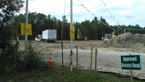
Where Sabal Trail connects to Transco: the head of the black snake,
 at Hillabee Power Plant, owned by Exelon Corp., near Alexander City, Alabama.
We were driving by, so we took some pictures.
Here are
Sabal Trail’s Alignment Maps
for this area,
the
photographs I took yesterday,
and
a google map with links to the pictures,
plus
what you can do to stop this unnecessary, destructive, and hazardous fracked methane pipeline boondoggle.
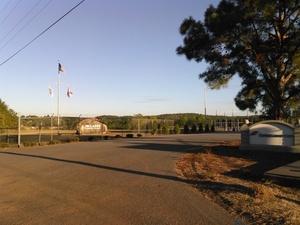
at Hillabee Power Plant, owned by Exelon Corp., near Alexander City, Alabama.
We were driving by, so we took some pictures.
Here are
Sabal Trail’s Alignment Maps
for this area,
the
photographs I took yesterday,
and
a google map with links to the pictures,
plus
what you can do to stop this unnecessary, destructive, and hazardous fracked methane pipeline boondoggle.
Update 2016-10-10: All 527 of Sabal Trail’s April 2016 alignment maps are now available in small, big, huge, and PDF formats, courtesy of Lowndes Area Knowledge Exchange (LAKE).