Tag Archives: Blueway

Rescheduled: Third Annual Mayor and Chairman’s Paddle, Withlacoochee River 2022-02-19

Update 2022-02-15: We’re go for this Saturday, February 19, 2022, for the Third Annual Mayor and Chairman’s Paddle. Saturday is going to be the coolest day of the week, but that’s low 39, high 64, much warmer than last month, and the water temperature at US 84 is currently 51F, much higher than the mid-40s last time. Dress warmly in layers and bring a dry change of clothes in a waterproof bag just in case. And come on down to Troupville Boat Ramp this Saturday!

Valdosta, Georgia, January 26, 2021 — An unusual cold snap is expected this Saturday, too cold for novice paddlers. So we’re rescheduling three weeks later, for Saturday, February 19, 2022. Everything else is the same; only the date has changed.

Lowndes County Chairman Bill Slaughter summed it up, “Safety should be considered above all and hypothermia is a huge issue if someone was to go in the water!”

Suwannee Riverkeeper John S. Quarterman added, “Water temperature was already down to 47 degrees Monday at US 84 on the Withlacoochee River, and air temperatures for this Saturday are predicted to be low of 22 and high of 42. So hypothermia is indeed a risk, however seldom seen in south Georgia. Also not many people would turn out in such cold.”

Valdosta Mayor Scott James said, “So we’re all agreed: Saturday, February 19, 2022. Come as early as 8AM to get on the shuttle!”
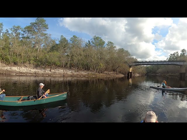
[Troupville Boat Ramp, Withlacoochee River, WWTP clean outfall, Spook Bridge, Takeout]
Troupville Boat Ramp, Withlacoochee River, WWTP clean outfall, Spook Bridge, Takeout

We hope there will still be plenty of water for this annual eleven-mile river paddle, past the future site of Troupville River Camp and Nature Park, along the west side of the most populous city in the Suwannee River Basin, past Valdosta’s clean outfall of its Withlacoochee Wastewater Treatment Plant, with many creeks, oaks, cypresses, pines, fish, turtles, and maybe an alligator, down to Spook Bridge, so scary it has its own movie.

Valdosta Mayor Scott James said, “I am excited to partner once again with WWALS, plus this time with Lowndes County, to show people our fabulous blackwater rivers, Continue reading

Video: Turner Bridge to FL 6, Suwannee River 2021-12-16

Here’s a video of the mid-December 2021 Ken Sulak Suwannee River paddle, the part from Turner Bridge to Cypress Creek South Launch at FL 6.

FL 6 bridge, Suwannee River 2021-12-16

The images are ten seconds apart. You can see Mike Byerly’s canoe parked over one of the Lally columns of Turner Bridge in the river. You can see Ken Sulak drop a magnet to confirm that it is metal. Continue reading

Chitty Bend East Distributary, Withlacoochee River –Shirley Kokidko 2022-01-07

Update 2023-08-27: Pictures: Sullivan Launch to Florida Campsites, Withlacoochee River 2023-07-15.

River scout Shirley Kokidko went to investigate Mystery: Withlacoochee River Distributary 2021-01-01 and came back with these pictures from Friday, January 7, 2022.

Remember: it’s not safe to paddle in there.

[Distributary, Swallet, Sinkhole]
Distributary, Swallet, Sinkhole

Chitty Bend East Distributary

The Withlacoochee River was 57.9′ NAVD88 (11.4′) on the Pinetta gauge. Continue reading

Pictures: Roline to FL 6, Suwannee River 2021-12-16

Update 2022-01-05: Turner Bridge mysteries –Ken Sulak 2021-12-16.

Nine of us paddled the Suwannee River from Roline to Cypress Creek South Launch at FL 6, mostly to see the remains of Turner Bridge, at the invitation of Dr. Ken Sulak, USGS, Retired, now researching bridge and history in the Suwannee River Basin. We saw a small gator, some dead top cypress trees, many health ones, and tupelo, pines, and oaks, as well a birds and a few fish. Mike Byerly discovered a small creek below Turner Bridge. Karst outcrops became more frequent the farther downstream we went. There was a shoal with waves for half a mile or so. An enjoyable warm winter day paddle.

[Roline, Gator, Turner Bridge, Byerly Creek]
Roline, Gator, Turner Bridge, Byerly Creek

Ken has written up his findings so far about Turner Bridge. Continue reading

Banks Lake Full Wolf Moon Paddle, 2022-01-17

Join us for our first 2022 leisurely Sunset and Full Moon Paddle at Banks Lake National Wildlife Refuge, just west of Lakeland, Georgia.

When: Gather 5 PM, launch 5:30 PM, moonrise 5:41 PM, sunset 5:55 PM, end 7:30 PM, Monday, January 17, 2022

Put In: Banks Lake Boat Ramp, 307 Georgia 122, Lakeland, GA 31635, in Lanier County, on the Alapaha River Water Trail (ARWT).

GPS: 31.034824, -83.096725

Take Out: Banks Lake Boat Ramp

Bring: the usual personal flotation device, boat, paddles, food, drinking water, warm clothes, and first aid kit. Also trash pickers and trash bags: every WWALS outing is also a cleanup. Mosquitoes can be bad at dusk so come prepared.

Safety: Each person in a boat, no matter how young or old, must wear a PFD. You must have a light for your boat or some type of light to have on yourself (glow sticks work well, or head lamp, flashlight, etc.) so other boaters can see you in the dark. It will be totally dark after sunset. A whistle is not required, but it’s a good idea in the dark.

Boats: Bring your own if you have it.
Thanks to Banks Lake Outdoors for free boat rental for these WWALS Full Moon Paddles.
Please ask for boats at least 2 days prior to the event: on the web form on https://wwals.net/outings, or on the facebook event, the meetup, or call 850-290-2350.

Free: This outing is free to WWALS members, and $10 (ten dollars) for non-members. You can pay the $10 at the outing, or online:
https://wwals.net/outings

We recommend you support the work of WWALS by becoming a WWALS member today!
https://wwals.net/donations/#join

Event: facebook, meetup

[Sunset big sky]
Sunset big sky. Photo: John S. Quarterman, 2021-12-18.

Continue reading

KUR: M2 Blue cave system, Madison County, Florida

Update 2022-01-10: Chitty Bend East Distributary, Withlacoochee River –Shirley Kokidko 2022-01-07.

What’s underneath the Mystery: Withlacoochee River Distributary 2021-01-01? The M2 Blue cave system in Madison and Hamilton Counties, explored by Karst Underwater Research (KUR).

There’s a “Gully / Swallet” marked on this KUR map of the M2 caves, very close to where the sinkhole at the end of the distributary. Both maps in this post are credited to KUR. Please follow the links for the rest of KUR’s descriptions, pictures, and videos. Continue reading

Pictures: Alapahoochee River, GA 135 to Sullivan Launch Sasser Landing 2021-06-05

Update 2023-01-26: Pictures: Many deadfalls, shark teeth, and rapids: Alapachoochee Adventure 2022-07-09.

Bird Chamberlain and others had been suggesting it for years, and we finally did it: the Alapahoochee River from GA 135 to Sasser Landing on the Alapaha River. We paddled over many deadfalls, across the GA-FL line, past the creek of shark teeth, under old abandoned steel Beatty Bridge, through Devil Shoal, right by Turket Creek Waterfall.

[Banners, Alapahoochee River, Deadfall, Beatty Bridge, Devil Shoal, Turket Creek Waterfall]
Banners, Alapahoochee River, Deadfall, Beatty Bridge, Devil Shoal, Turket Creek Waterfall

Many thanks to Bobby McKenzie for organizing this expedition, to the WWALS Outings Committee for planning it, and to all who paddled, including Suzanne Welander, author of Canoeing and Kayaking Georgia, who came down from Atlanta for this outing. Continue reading

Mystery: Withlacoochee River Distributary 2021-01-01

Update 2022-01-10: Chitty Bend East Distributary, Withlacoochee River –Shirley Kokidko 2022-01-07.

Update 2021-12-28: KUR: M2 Blue cave system, Madison County, Florida.

Where exactly does Withlacoochee River water run into this creek, about three hundred feet into the woods, and disappear into a sinkhole? Left (east) bank, which is state land, or right (west) bank, which is private land? If it doesn’t have an observation platform, where is the one pictured? Maybe you can help us resolve this mystery.

One thing is clear: do not paddle into this distributary! When the river is high, the current is high, and you will have a hard time gettin back out. There are deadfalls and a sinkhole at the end.

[Platform, Distributary]
Platform, Distributary

Here’s where this mystery started:

“Some 7 miles downriver from CR 150, there is a 10- to 12-foot opening in the high banks on the east side where water comes rushing out of the river. If followed, this stream flows for 75 to 100 yards and then disappears under a high bank. In Florida, whole rivers disappear in this manner, but it is unusual to lose just part of a river.”

That’s from Canoeing & Kayaking Florida, Menasha Ridge Press; 2nd edition (November 11, 2007), by Johnny Molloy, Elizabeth F. Carter et al., Page 122, Georgia State Line to Suwannee River S.P. Hm, I see there’s now a third edition of November 11, 2016.

Helen Crowley says she and Shirley Kokidko and Don Crowley paddled past there on January 1, 2021. She sent this picture as of the distributary. Continue reading

Pictures: Banks Lake Full Cold Moon paddle 2021-12-18

The wind was brisk but died down as soon as we started paddling on a warm winter night, to see the sun set and the moon rise over Banks Lake, our mini-Okefenokee just west of Lakeland, Georgia.

[Banners, Sunset, Moonrise]
Banners, Sunset, Moonrise

Russell even saw an osprey nest. Continue reading

History of Alapaha River Bridges, US 41 to Nobles Ferry –Ken Sulak 2021-12-08

Dr. Ken Sulak, USGS, Retired, sent us some things to look for as we paddle the last stretch of the Alapaha River on February 5, 2022.

[Pictures and Maps, Lower Alapaha River Bridges]
Pictures and Maps, Lower Alapaha River Bridges

For your upcoming [5] Feb Alapaha adventure, some of your folks might be interested in the history of three crossing sites you will encounter. So, here you go very briefly: Continue reading