Tag Archives: Bret Wagenhorst

Update on Rowetown Church to GA 135: WWALS outing 2015-04-18

300x117 Rowetown with Alapaha, GA gauge, in Alapaha River Water Trail, by John S. Quarterman, for WWALS.net, 16 April 2015 Update from expedition leader Bret Wagenhorst:

The current weather forecast for Saturday in Alapaha, GA is cloudy with 20% chance of thunderstorms. The water level on the Alapaha River at the Alapaha gauge is 9.4 ft and appears to be plateauing. [The river has already been going down for a couple of days upstream at the Irwinville gauge. -jsq] Unless there are heavy rains in or north of Alapaha Friday, we should be able to proceed with our planned outing.

It should be a fast trip with the water this high, and with fast, high water comes increased risk, so this is probably not a great outing for a beginner.

Know that the put in is actually Continue reading

Summary of Statenville to Sasser Landing WWALS Outing –Bret Wagenhorst 2015-02-15

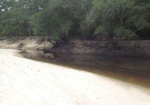
Saw: tupelo, cypress, maple, river birch, pine, live oak, titi, mayhaw, native blueberries, palmetto; only maple in bloom. Not much wildlife.

300x225 WWALS At Sasser Landing, in Sasser deanna, by Deanna Mericle, for WWALS.net, 15 February 2015 
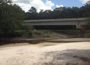
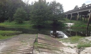
River: several small streams entered river through breaks in the bank, winding course, couple of bluffs and some exposed karst

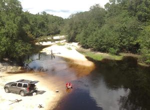
Comments: a good level to run this section, saw 2 other canoes with a family of campers, and a fisherman in a john boat skinning a catfish, 2 rope swings, the side trip up the Alapahoochee River to the waterfall just up from the take out was worth the effort.

Pictures: see separate post by Bret Wagenhorst. And pictures by John S. Quarterman.
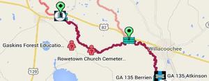
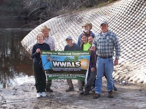
Ten of us met at 12 noon Sunday afternoon, February 15th 2015, continuing our exploration of the Alapaha River Water Trail, as announced.

The shuttle took Continue reading

Outing summary, Expert paddle on the Alapaha River from US 82 @ WWALS 2015-01-17

Outings Committee Chair Bret Wagenhorst sent this report. See also pictures and videos. -jsq

300x225 Movie: Go right (1.4M), in Alapaha deadfalls, by John S. Quarterman, for WWALS.net, 17 January 2015 Participants: Heather Braswell, Jack Hartley, Chris and Deanna Mericle, John Quarterman, Bret Wagenhorst

Put in: public boat ramp on east side of Hwy 82 bridge, east of Town of Alapaha.

Take out: private land near Rowe Town Church cemetery (permission obtained thru Heather)

Distance on River: Continue reading

Alapaha River @ GA 135, Berrien County south of Willacoochee

Update 2020-09-07: This location is now known as Nashville Landing.

300x210 There is a long sandy beach upstream from the bridge, which is a popular summer hangout for locals., in GA 135 Alapaha River access, by Bret Wagenhorst, for WWALS.net, 14 September 2014 There is a long sandy beach upstream from the bridge, which is a popular summer hangout for locals.

Bret Wagenhorst took these pictures 14 September 2014.

See also Alapaha River Water Trail. Continue reading

Berrien Beach at GA 168 on the Alapaha River

300x221 Public access on north side of bridge, with cement strip boat ramp at higher water level but no facilities. Access road is unpaved and about 1/4 mile long. Nice sandy beach., in Berrien Beach at GA 168 on the Alapaha River, by Bret Wagenhorst, for Bret Wagenhorst took these pictures of a well-known Berrien County fishing, swimming, and boating spot 19 September 2014, and posted them in a facebook album. At the GA 168 bridge, access is on the north side, west of the river. To get to the famous sandy beaches, boat downstream south under the bridge.

And don’t forget, farther downstream: Alapaha Sink: WWALS Outing 2PM 26 Oct 2014. Continue reading

Alapaha River access at Hwy 82 at very low water

300x179 The cement strip boat ramp is uneven, in Alapaha River access at Hwy 82 at very low water, by Bret Wagenhorst, for WWALS.net, 14 September 2014 Pictures of the location of the Alapaha River Cleanup at US 82, 27 September 2014, taken east of the town of Alapaha at US 82 on the Alapaha River by Bret Wagenhorst.

And this access point is on the Alapaha River Water Trail WWALS is developing.

Continue reading

Outing at Avera’s Mill Pond (Lewis Lake)

Lewis Lake, site of today’s outing at 4PM, is Avera’s Mill Pond. According to Wenda Gaile Bailey, “there was a partial draining of the lake late last year”, but she checked the water level yesterday. Here’s some history, and some pictures from five years ago of what you may see today.

WG Bailey wrote for WG Bailey photos, unknown date, Old Fashioned Pond Draining at Lake Lewis,

Avera’s Mill Pond, the oldest and largest pond in Berrien County, was founded by William M. Avera, son of pioneer, Daniel Avera, covers 1470 acres, and was built in the 1870’s at a cost of $3800.87

The mill dam is located Continue reading

Still time to register for BIG Little River Paddle Event

WWALS Outings Chair Bret Wagenhorst says:

Don’t forget, there is a great opportunity to enjoy the scenic beauty of one of our south GA blackwater rivers and help raise money for WWALS and Friends of Reed Bingham this coming Saturday, March 22 at The second annual BIG Little River Paddle Event. There is still time to register on line.