Tag Archives: gage

Rivers Seven Days After Irma 2017-09-17

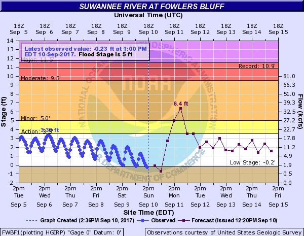
Looks like we may finally see Action stage tomorrow on the Withlacoochee River above Valdosta @ Skipper Bridge Road. This is upstream from Valdosta’s Withlacoochee Wastewater Treatment Plant, so it’s a good thing that didn’t spill during Irma. The Alapaha River at Statenville peaked Tuesday and probably would be a fine ride (what shoals?) today. The New and The Santa Fe Rivers are still flooding, and that’s still raising the Suwannee River all the way to the Gulf, and there’s minor flooding all the way up at Fargo, so another surge of high levels may follow on the Suwannee. The I-75 Santa Fe River bridge never did close.

2017-09-17 Withlacoochee River above Valdosta @ Skipper Bridge Road

The Suwannee River at White Springs peaked Continue reading

River Gage Projections after Hurricane Irma 2017-09-14

Update 2017-09-15: On the seventh day.

Update 2017-09-15: Added Suwannee River at Wilcox @ US 19, plus another image for the Gage Map.

Hurricane Irma flooded the Suwannee River at White Springs, the Santa Fe River especially at Fort White, with a new record for the New River new Lake Butler. It did not flood the Withlacoochee or Alapaha Rivers.

N2017-09-14 Suwannee River at White Springs
2017-09-14 Suwannee River at White Springs

FDOT says the I-75 bridge over the Santa Fe River Continue reading

River Gage Projections for Hurricane Irma 2017-09-10

Update 2017-09-15: On the seventh day.

Hurricane Irma is bringing flood levels on on most of the rivers in the Suwannee River Basin. Here are the gages with projections from downstream to upstream, since Irma is coming from the south. The images here are static to show this moment, but click on any image to go through to the live gage.

Suwannee River

Suwannee River at Fowlers Bluff

Suwannee River at Fowlers Bluff

Suwannee River at Branford @ US 27

Continue reading

Video: Steam engine, bridges, trees, beaches, and trash: Alapaha River by Diane Shearer

Also boating, deadfalls, steam engine, and rapids. Diane Shearer presented slides about the Alapaha River of her homeland, 31 March 2012 at Georgia River Network Weekend for Rivers, and said:

Right there at Alapaha, where it’s been clearcut behind it. This is one of the main problems of the river: there used to be nothing on that shore there but huge cypress trees and tupelo trees, and that’s almost gone everywhere. And that’s one of the great dangers to this river, is agricultural runoff, the fact that people can suck all the water out of it they want to, for irrigation and those sorts of things.

The video starts Continue reading

Typical USGS streamgage costs with example near Okapilco Creek

Update 2021-03-09: The funding cost per gauge has gone up, to $22,500, of which usually the USGS contributes about $900.

How much would it cost to fund the Okapilco Creek gage so it won’t go offline July 31st? 300x342 Pie: Percentages of funding in various activities, in Streamgage Operation and Maintenance Cost Evaluation, by U.S. Geological Survey, for WWALS.net, 1 June 2010 About $13,600/year, more or less, mostly for field and office labor and administration, with only 10% for the field equipment. Since this gage is located in Brooks County, Georgia, the most likely funding body (after USGS itself) would be the Brooks County Commission. Yes, it’s in WWALS watersheds; no, WWALS doesn’t plan to take on funding streamgages. If some funding organization appeared that wanted to pass the funds through WWALS, which is a 501(c)(3) educational institution, that would be possible. But this seems more like a government issue.

Costs

Continue reading

Funding needed for Okapilco Creek gage

In USGS Groundwater Data for Georgia:

The following streamgage will be shut down on July 31, 2015 unless alternative funding can be found:

  • 02318700 Okapilco Creek at Georgia Highway 333, near Quitman, Georgia

For questions regarding this threatened streamgage, please contact Tony Gotvald at (678) 924-6648 or agotvald@usgs.gov.

-jsq

USGS Flood-Tracking Chart for Withlacoochee and Little River Basins

An interesting flyer pointed out by Emily Davenport, Storm Water Utilities Director, City of Valdosta. It has many useful contacts on the front, and tips on the back (don’t walk or drive through flood waters) but the most useful part is inside, where the flood-tracking chart is, in Flood-tracking chart for the Withlacoochee and Little River Basins in south-central Georgia and northern Florida, 2014, by Gotvald, Anthony J.; McCallum, Brian E.; Painter, Jaime A., USGS General Information Product: 155.

Here are the gages mentioned in the chart, with links to the live USGS FloodTracking pages, Continue reading