Tag Archives: Irwin County

Alapaha River precipitation and levels

300x153 90 Days Levels Graph, in Alapaha River Levels and Precipitation, by USGS, for WWALS.net, 7 March 2015 
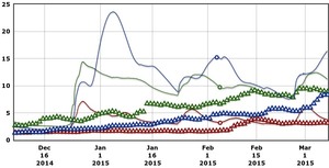
Rainfall can be quite different in Statenville on the Alapaha River as shown here than in Valdosta on the Withlacoochee River. But remember half of Valdosta drains into the Alapaha River watershed.

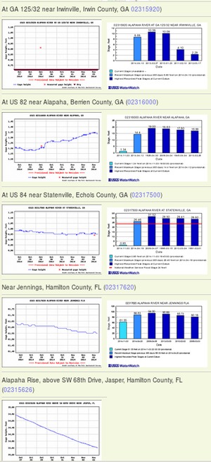
Here are rainfall and water level graphs from the three USGS Alapaha River gauges in Georgia. The Florida gauge is shown separately, because it use a different base level, and precipitation doesn’t seem to be available from Florida gauges. See also always-current graphs of all the levels. Continue reading

Alapaha River water levels

Update 2025-09-21: Graphs from water.noaa.gov.

300x655 Example 2014-11-03, in Alapaha River Water Levels, by John S. Quarterman, for WWALS.net, 3 November 2014 Update 2016-12-23: graphs from water.weather.gov.

Update 2016-05-31: See sea level gage reports.

Update 2015-04-28: Added flood stages and tentative highest safe and lowest boatable water levels, both above the charts for each gauge and in a summary table. If you have data, please let us know.

Here are water level gauges for the Alapaha River in Georgia and Florida, north to south. The graphs should show the current levels at this time, in feet, plus for most of the gauges a bar graph of selected historic levels.

This is a draft of a concept for use with the Alapaha River Water Trail. See also Alapaha River Rainy Season.

It is also a companion to the similar set of graphs for the Withlacoochee and Little Rivers.

See below for the current Alapaha River water level graphs. Continue reading