First time we’ve seen this: 300 gallons of raw sewage spilled from Rochelle, Georgia, in Wilcox County, at the top of the Alapaha River Basin.

Rochelle is nestled between Continue reading

First time we’ve seen this: 300 gallons of raw sewage spilled from Rochelle, Georgia, in Wilcox County, at the top of the Alapaha River Basin.
Rochelle is nestled between Continue reading
GA-EPD’s Atlanta office sent
their entire sewage spill database for January 2017 in response to an open records request from WWALS.
 For the Suwannee River Basin,
I see only the known ones by Valdosta, plus a spill from Moultrie’s
Carlton Woods Lift Station into the Ocholockonee River,
with 36000 gallons, which matches
the amount we got directly from Moultrie.
That Ochlockonee spill is still not in the Suwannee River Basin.
For the Suwannee River Basin,
I see only the known ones by Valdosta, plus a spill from Moultrie’s
Carlton Woods Lift Station into the Ocholockonee River,
with 36000 gallons, which matches
the amount we got directly from Moultrie.
That Ochlockonee spill is still not in the Suwannee River Basin.
The Georgia Environmental Protection Division (GA-EPD) Southwest office in Albany handles the other sewage treatment operations in the Suwannee River Basin in Georgia, and that Albany office already told us by telephone that they had no reported spills other than the Tifton spill into the New River which I had gotten directly from Tifton. So I think we can conclude there were no other sewage spills into the Suwannee River Basin in Georgia in January 2017 other than the ones from Valdosta and Tifton.
Interestingly, Valdosta with its 2.2 million gallon Withlacoochee Wastewater Treatment Plant (WWTP) leak (and three manhole spills) was not the winner. Continue reading
Force main and the new WWTP on line by May!
More extensive overflows than usual last weekend, and now more extensive information about them,
 in
the update Tim Carroll promised,
on the City of Valdosta website as
City System Impacted by Severe Storms and Regional Watershed.
It even starts with schedule details, which say they’re
ahead of
the schedule I previously posted.
This report’s table of overflows has start and stop times and amounts, with the Creeks affected.
in
the update Tim Carroll promised,
on the City of Valdosta website as
City System Impacted by Severe Storms and Regional Watershed.
It even starts with schedule details, which say they’re
ahead of
the schedule I previously posted.
This report’s table of overflows has start and stop times and amounts, with the Creeks affected.
It still doesn’t say which river basin they go into. Knights Creek flows into Mud Creek, which goes into the Alapahoochee, Alapaha, and Suwannee Rivers. All the others end up in the Withlacoochee and the Suwannee Rivers. And there are still some unanswered questions. But getting the force main and the new WWTP on line by May is a very good development.
The City of Valdosta is ahead of schedule and plans to bring online nearly $60 million in wastewater system improvements next month. The $35 million Force Main project and the $23 million new Withlacoochee Wastewater Treatment Plant (WWTP) are both ahead of schedule, and bringing them both online cannot come a day too soon for the city.
“We are pleased to be in the final stages of construction on both projects. Testing is underway now with full startup expected in late May,” according to Director of Utilities Henry Hicks. “We are also pleased that these projects and other awarded sewer collection system improvement projects underway will resolve all the areas of the city impacted by reoccurring overflows that often follow heavy rains and regional flooding.”
Continue reading
Update 2016-04-05: Here are the details, and force main and new WWTP on line by May.
Valdosta spilled more wastewater over the weekend,
according to Valdosta City Council Tim Carroll, who called just now.
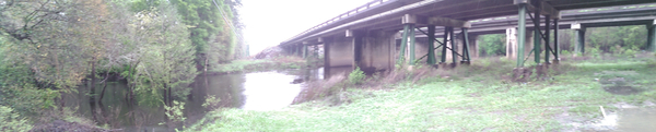
 The Withlacoochee River is out of its banks, actually up on the property containing the Withlacoochee Wastewater Treatment Plant (WWTP), but “according to the experts” not going to threaten the plant. “But lines are underwater”.
Water is not even close to the new WWTP currently under construction, according to Carroll. And the new force main project should deal with much of the manhole overflow problem on the west side of Valdosta in the Withlacoochee basin, for example into Sugar Creek.
On the east and southeast, in the Alapaha basin, Continue reading
On the north side of US 41, there’s good access from Val Del Road to the Withlacoochee River.
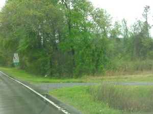 From US 41 (North Valdosta Road), turn north on Val Del Road,
and your next right is a turnoff to a gravelled road that bends sharply right into the woods, which leads back to the north side of US 41 and down to the Withlacoochee River.
It was a bit muddy in the rain this morning, but there were no big potholes,
and the river slope is easy access.
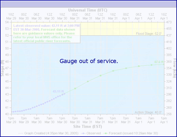
The river was high, 9.8 feet, but still well below the 15 foot flood level
on the
US 41 Gage on this bridge.
From US 41 (North Valdosta Road), turn north on Val Del Road,
and your next right is a turnoff to a gravelled road that bends sharply right into the woods, which leads back to the north side of US 41 and down to the Withlacoochee River.
It was a bit muddy in the rain this morning, but there were no big potholes,
and the river slope is easy access.
The river was high, 9.8 feet, but still well below the 15 foot flood level
on the
US 41 Gage on this bridge.
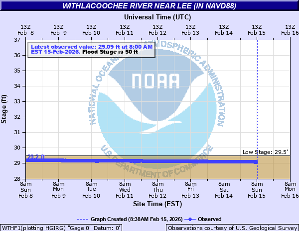
Update 2025-09-21: Graphs from water.noaa.gov.
 Related to the
Withlacoochee and Little River Water Trail
and the
double USACE flooding study presentation tonight in Valdosta,
here are river level charts
upstream and down on the Little River,
Okapilco Creek, and the Withlacoochee River
related to a new USGS flood-tracking chart.
In the example charts on the right, you can see the Little River peaked days ago at Tifton and yesterday at Hahira.
Related to the
Withlacoochee and Little River Water Trail
and the
double USACE flooding study presentation tonight in Valdosta,
here are river level charts
upstream and down on the Little River,
Okapilco Creek, and the Withlacoochee River
related to a new USGS flood-tracking chart.
In the example charts on the right, you can see the Little River peaked days ago at Tifton and yesterday at Hahira.
The Withlacoochee River peaked yesterday at US 41. while downstream it’s going up at US 84, and barely starting up at Pinetta (click on the above chart example for the rest). Right now you can see all that in the charts below. If this works, you’ll see something different later, because you’ll see current charts whenever you refresh this page.


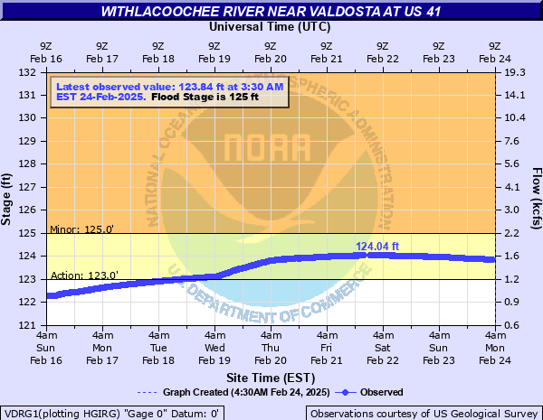


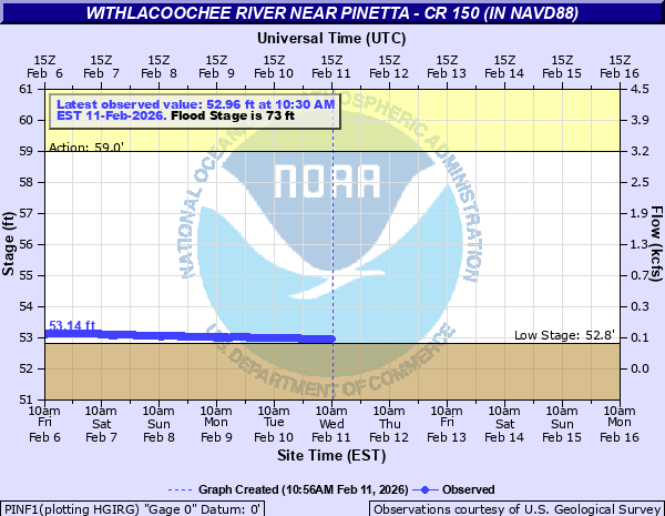
See also interactive map.

Update 2016-05-31: See sea level gage reports.
Update 2016-04-27: graphs from water.weather.gov and some WRWT Safe Water Levels.
Update 2014-11-04: Simplified gage formatting.
Update 2014-11-03: That works, and see also Alapaha River water levels.
-jsq, John S. Quarterman, Suwannee RIVERKEEPER®
You can help with clean, swimmable, fishable, drinkable, water in the 10,000-square-mile Suwannee River Basin in Florida and Georgia by becoming a WWALS member today!
https://wwals.net/donations/