Tag Archives: north Florida

Videos: Mayor and Chairman’s Paddle, Trash, Swamp: Suwannee Riverkeeper on Scott James Radio 2020-01-20 2022-01-20

The Mayor and Chairman’s Paddle has been rescheduled to Saturday, February 19, 2022. Everything else is as Valdosta Mayor Scott James and I discussed on his radio show last Thursday. We’ll be talking about it again this Friday, January 28, 2022, at 8AM, Talk 92.1 FM.

Thanks to The Langdale Company for access to take out at Spook Bridge, and for a mid-point lunch spot. Thanks to Georgia Power for water quality testing grants to WWALS.

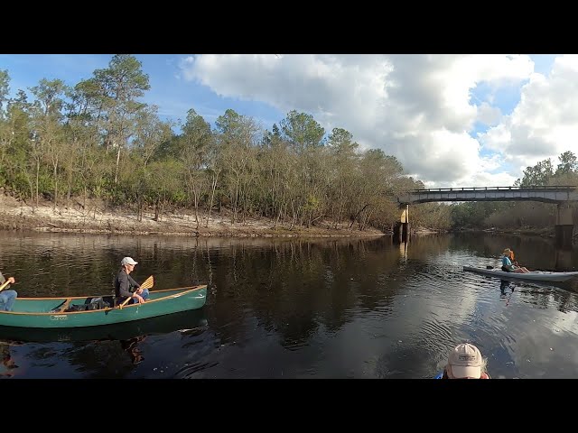
Gather 9AM for the Chairman and Mayor’s Paddle, at the rescheduled Saturday, February 19, 2022.

[Mayor and Chairman's Paddle (since rescheduled to February 19, 2022)]
Mayor and Chairman’s Paddle (since rescheduled to February 19, 2022)

We hope everybody’s favorite on-water painter, Julie Bowland, will join us.

WWALS is talking to Valdosta State University Deans and Faculty about Education and research at Troupville River River Camp and River Park. The paddle will go right by there.

On the radio, Scott James and I discussed the trash problem, coming mostly from parking lots with fast food outlets, down Sugar Creek, into the Withlacoochee River.

Arrow the talking puppy helped.

Don’t forget to tell GA-EPD no mine near the Okefenokee Swamp.

WWALS has a paddle on the last stretch of the Alapaha River, US 41 to Suwannee River, Saturday, February 5, 2022.

And a paddle from Langdale Park on the Withlacoochee River, to Sugar Creek, and on to Troupville Boat Ramp, May 7, 2022: the announcement will be up soon.

The Sugar Creek trash problem was described in the 2010 Valdosta Stormwater Master Plan, which said it should be fixed immediately. Continue reading

Sullivan Slough and Blue Sink by Amanda Davis 2022-01-18

Thanks, Amanda Davis, for these pictures of Sullivan Slough and Sullivan Blue Sink.

Is it a sink or a spring? Probably a bit of each: a karst window, where the aquifer is exposed. So at high river water levels, the Withlacoochee River probably runs into it. At low river levels, water probably flows into the river.

[Sullivan Blue Sink and Slough, Withlacoochee River]
Sullivan Blue Sink and Slough, Withlacoochee River

Here’s where it ends up. Continue reading

Bad Withlacoochee River water quality 2022-01-20

Update 2022-01-28: Clean Rivers 2022-01-27.

I’d avoid the Withlacoochee River this weekend.

Bad E. coli levels upstream seen by Valdosta earlier in the week were still seen by WWALS upstream and down in Thursday samples. A too-high result at Hagan Bridge is heading downstream through Lowndes and Brooks Counties, Georgia. A too-high result at Knights Ferry is heading downstream to Florida.

The good news is no sewage spills have been reported this week. But it’s been raining yesterday and today, most likely washing more cattle and other manure into the river, down Okapilco Creek and from elsewhere.

If you want to paddle this weekend, I’d recommend the Alapaha River or upstream on the Suwannee River.

[Chart, River, Plates, Swim Guide]
Chart, River, Plates, Swim Guide

Valdosta’s downstream results for Monday and upstream for Wednesday were even worse than what WWALS got for Thursday. We don’t know about upstream Monday because Valdosta took a vacation. We don’t know about downstream Wednesday because Valdosta’s downstream contractor apparently hasn’t phoned home yet. Continue reading

Blue Sink, Sullivan Slough –Susan Liden 2021-01-18

Update 2022-01-21: Sullivan Slough and Blue Sink by Amanda Davis 2022-01-18.

Sullivan Slough is the real name of what we’ve been calling Chervil Drive Distributary, and Blue Sink is what local people call Chervil Drive Sinkhole.

Sullivan Blue Sink is where Withlacoochee River water ends up after flowing into Sullivan Slough, 0.83 miles downstream from Florida Campsites Boat Ramp, 0.73 miles upstream from the FL 6 bridge, and 0.83 miles up from Madison Blue Spring.

Traditionally, this has been a popular local swimming spot. However, the land containing the sink sold recently, so status is unclear now. We do have an offer from somebody with land nearby to tour the area.

Susan Liden sent these pictures. Thanks, Susan!

[Blue Sink and Sullivan Slough]
Blue Sink and Sullivan Slough

This one I think is particularly impressive. Continue reading

Sugar Creek Trash 2022-01-15

Trash lined both sides of Sugar Creek all the way to the Withlacoochee River Saturday.

Trash jams behind their houses probably don’t make people very happy in Wood Valley subdivision half a mile down the river.

At the proposed site of Troupville River Camp and Troupville River Park, trashjams at the Little River Confluence make those projects less viable, despite promotion by One Valdosta-Lowndes, VLPRA, Valdosta, Lowndes County, and WWALS.

Floridians do not thank Valdosta for this trash gift, which trash washes downstream into Florida and the Suwannee River, onwards to the Gulf.

[Trash down Sugar Creek and Withlacoochee River]
Trash down Sugar Creek and Withlacoochee River

This problem has been known to the City of Valdosta since at least 2010, when it finished its Stormwater Master Plan (SWMP). The SWMP describes and includes a photograph of the notorious Sugar Creek trashjam near the bottom of the Salty Snapper property. Continue reading

Chervil Drive Distributary, Withlacoochee River 2022-01-13

Update 2022-01-21: Blue Sink, Sullivan Slough –Susan Liden 2021-01-18.

Another Withlacoochee River distributary to a sinkhole! This one revealed by WWALS member and archaeologist Tom Baird. I’m calling it Chervil Drive Distributary because we don’t know any more traditional or official name for it. It’s downstream from the Chitty Bend East Distributary and on the other side of the river.

[Chervil Distributary, Withlacoochee River, Madison County, FL]
Chervil Distributary, Withlacoochee River, Madison County, FL, in the WWALS map of the Withlacoochee and Little River Water Trail (WLRWT).

Another interesting feature is further down river on the right bank about a mile above Madison Blue Springs. At flood, water pours through a gap in the limestone bank and floods a large channel that goes back to a deep sink. The weight of water in the past broke through the ceiling of a cavern and created a beautiful, clear, good-sized swimming hole. It was evidently a popular swimming and picnic spot in the past. Don’t know the correct name of the feature; my wife and I call it “Thanksgiving Spring”, because we found it while hiking around one Thanksgiving Day. However, it’s not a spring (no water comes from it), but an opening to the water table. Nice and cool on a hot day. J

Continue reading

More than 40 scientists oppose strip mine near Okefenokee Swamp 2021-11-30

Dozens of scientists across the U.S. have written a letter spelling out dangers of strip mining near the Okefenokee Swamp.

They couldn’t cover everything, but they found scientific evidence running from habitat loss, fire risk, and lowering the Floridan Aquifer, to dark skies, tourism, and economy, including: “Mining will impact the water quality of the Okefenokee Swamp and downstream rivers, including the St Mary’s and Suwannee Rivers, through release of stored chemicals, including toxic heavy metals.”

You can mention the scientists’ letter when you ask the Georgia Environmental Protection Division to deny the miners’ permit applications.

[Heavy Mineral Mining In The Atlantic Coastal Plain-0006]
The mine site is labeled Saunders Tract in the middle of this map. See Figure 5.

The situation is no different from when DuPont tried to mine next to the Swamp twenty years ago. As Gordon Jackson points out in The Brunswick News (December 9, 2021), “The argument two decades ago and today is there has never been a comprehensive study to show how much of an impact, if any, disturbing the layered soil would have on the refuge.”

Naturally, the miners disagreed, according to Emily Jones for WABE (December 1, 2021): Continue reading

Jennings Bridge, Alapaha River 2022-01-05

Ken Sulak, retired from USGS, sent this update on the Alapaha River bridge site 0.8 miles downstream from Sullivan Launch Sasser Landing, or 0.64 miles downstream from the CR 150 bridge. Plus a likely old ferry site, and maybe a previous location of Sullivan Launch Sasser Landing.

[Jennings Bridge, Alapaha River, c. 1989]
Jennings Bridge, Alapaha River, c. 1989 –Florida Memory

This is the site of the ‘Jennings Bridge’, a steel through-truss bridge, apparently built around 1902-1903. Some online bridge websites state that this is the oldest steel/iron highway bridge in Florida. But, that is doubtful—if the construction date I have is correct. For example, the ‘Adams Bridge’ aka ‘Steel Bridge’ in White Springs was built in 1891, and the original 2-span bowstring style bridge, the ‘Lee Bridge’ over the Withlacoochee (right where the current CR-141 bridge is located) may have been built in the late 1880s. I would like to explore the riverbank and look at what remains of the bridge supports. If there are cutoff Lally columns, then the Jennings Bridge was probably indeed built around 1902-1903. But if the supports are old limerock concrete or brick, then it would have been built before 1898.

[Jennings Bridge in WWALS ARWT map]
Jennings Bridge in the WWALS Alapaha River Water Trail (ARWT) map.

Anyway, I was just writing to note the name of the Jennings Bridge—you might want to add that to your interactive map. Hinton’s 1976 History of Hamilton County calls it by that name, as well as Florida Memory. Some folks say it collapsed in the late 1970s, one article says 1981, Florida Memory Archive has several photos of the falling-apart, but still-standing bridge dated 1989.

Continue reading

Video: Turner Bridge to FL 6, Suwannee River 2021-12-16

Here’s a video of the mid-December 2021 Ken Sulak Suwannee River paddle, the part from Turner Bridge to Cypress Creek South Launch at FL 6.

FL 6 bridge, Suwannee River 2021-12-16

The images are ten seconds apart. You can see Mike Byerly’s canoe parked over one of the Lally columns of Turner Bridge in the river. You can see Ken Sulak drop a magnet to confirm that it is metal. Continue reading

Bad US 84 Wednesday, good Withlacoochee River Thursday 2022-01-13

Update 2022-01-21: Bad Withlacoochee River water quality 2022-01-20.

Rains last weekend got contamination into the Withlacoochee River upstream at US 84, still showing up Wednesday in Valdosta results. But all the WWALS results for Thursday and downstream Wednesday showed acceptable low levels of E. coli.

So I’d paddle and fish in the Withlacoochee River today. Not so sure about swimming: it’s cold.

[Chart, River, Swim Guide]
Chart, River, Swim Guide

As you can see, Valdosta got bad results at US 84 for both Monday and Wednesday. Continue reading