Tag Archives: Withlacoochee River

Cancelled! Paddle Against the Pipeline on the Withlacoochee River: 19 April 2014

Update 9PM 16 April 2014: Cancelled due to flood-stage water levels in the Withlacoochee River, with more rain expected Friday. To be rescheduled.

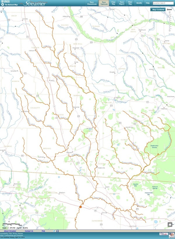
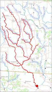
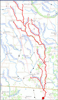
7:30 AM Saturday 19 April 2014 on the Withlacoochee River between Valdosta and Quitman, put in at Old Quitman Road on the Brooks County side (just south of US 84): Paddle past where the proposed Sabal Trail methane pipeline would cross the Withlacoochee River, digging into our fragile karst limestone, above our drinking-water Floridan Aquifer. This is a joint event of Continue reading

How Many Trees Does It Take to Protect a Stream?

Stroud Water Center wrote in their Upstream Newsletter, VOL. 2014, ISSUE 1, February 2014,

Scientists Set Buffer Width Minimum Standard.

A strip of forest along a stream channel, also called a riparian forest buffer, has been proposed and used for decades as a best management practice to protect streams by filtering out contaminants from agriculture and other land uses before they can enter them.Their benefits are many, but one benefit has dominated social and political conversations, and that is their role in preventing contaminants from entering streams.

20140317-140845.jpg
Stroud Center Director Bern Sweeney practicing what he preaches at a tree planting event. Photo: David Arscott

A few years ago, Stroud Water Research Center proposed that riparian forest buffers also play another important role by Continue reading

Georgia Outdoor Map

Interesting interactive map by Georgia Department of Natural Resources, Georgia Outdoor Map. Their PR of 14 March 2014, DNR Launches Interactive Map of Recreational Lands,

The Georgia Department of Natural Resources (DNR) today unveiled an interactive map that identifies DNR-managed lands and outdoor recreation opportunities. The “Georgia Outdoor Map” includes state parks, wildlife management areas, public fishing areas, boat ramps, and historic sites. Users are able to search by category to find locations where they can camp, hunt, hike, fish or explore history.

Continue reading

Draft Agenda for WWALS March 2014 board meeting

Board meetings are open to the public. Board members are listed on the website.

Draft Agenda
WWALS Board of Directors
7:30 PM Wednesday 12 March 2014
IHOP, Adel, GA
  1. Call to Order, Welcome and Introductions
  2. Speaker, 20 minutes: Charles Stines about his experience on our region’s rivers.
  3. Agenda Review: Additions and Changes
  4. Review and Approval of Minutes
    1. 12 February 2014 Board meeting minutes
  5. Past Meetings and Events
    1. Monthly outing February (fourth Saturday): February 22 – location? Cancelled due to all rivers too high.
  6. Future Meetings and Events Continue reading

Draft Agenda for WWALS March 2014 board meeting

Board meetings are open to the public. Board members are listed on the website.

Draft Agenda
WWALS Board of Directors
7:30 PM Thursday 13 March 2014
IHOP, Adel, GA if speaker, else by teleconference
  1. Call to Order, Welcome and Introductions
  2. Speaker, 20 minutes: Charles Stines about his experience on our region’s rivers.
  3. Agenda Review: Continue reading

WWALS in Waycross at EPA Seven Out Superfund meeting

It’s a serious situation in Waycross, with people getting sick and dying. The contamination, whatever it is, may have crossed into WWALS watersheds, as well. Good interactions between WWALS, Satilla Riverkeeper, and silentdisaster.org, plus EPA, GA EPD, and GA Health Dept.


Matthew J. Huyser, EPA (l. standing blue shirt), Jim Brown, GA EPD (c. standing white shirt), Ashby Nix, Satilla Riverkeeper (facing Brown, paper in hand), Joan Martin McNeal, silentdisaster.org (r. in group)

For details, see these posts on Lowndes Area Knowledge Exchange (LAKE): Continue reading

Ichetucknee Alliance thinks it got the pipeline to move

According to their facebook page today, a conservation group in Florida convinced Sabal Trail to steer clear of their springs. Or did they? The “written assurances” they they got from Spectra’s Andrea Grover say “preferred” and “currently”. In any case, some of Ichetucknee Alliance’s positions are just as valid in WWALS’ watersheds.

Here’s an excerpt from their position, Ichetucknee Alliance Pipeline Position Paper, 21 August 2013, Continue reading

Pipeline would cross Withlacoochee River twice

The detail maps in the General Project Description in the 15 November 2013 update to FERC by Sabal Trail Transmission reveal that the proposed path would cross the Withlacoochee River both where the river is the border of Brooks and Lowndes County and where it is the border between Hamilton and Madison County near Ellaville. In between, the pipeline would run through many wetlands near the river and through quite a few recharge zones for our drinking water source, the Floridan Aquifer. Then it crosses our downstream river, the Suwannee, into Suwannee County, Florida.

Continue reading

Entering Floridan Aquifer Recharge Zone

Maybe we need signs like that around here to remind people that what goes into the ground comes out in our drinking water. For example, San Antonio has its Edwards Aquifer Protection Program. Maybe our local governments need to have Floridan Aquifer Protection Programs. Georgia state law seems to indicate they should.

GA Secretary of State has GA Code §391-3-16-.02 Criteria For Protection of Groundwater Recharge Areas. (more legible copy on GA EPD website),

Georgia's Groundwater Recharge Areas (1) Background. Variable levels of recharge area protection can be based upon the State’s hydrogeology (e.g., areas such as the Dougherty Plain where a major aquifer crops out would receive a relatively high degree of protection whereas other areas, such as the shale hills of northwest Georgia, would receive a lower degree of protection). Recharge area protection within the significant recharge areas would be further refined, based upon the local susceptibility or vulnerability to human induced pollution (e.g., high, medium, or low). The significant recharge areas have already been identified and mapped (about 22-23% of the State). Pollution susceptibility mapping is ongoing. Existing statutes are adequate for protecting the remaining recharge areas (about 77-78% of the State).

[…]

(2)(f)3. In the Coastal Plain, the significant recharge areas are Continue reading

Streamer on the Suwannee, Alapaha, and Withlacoochee Rivers: ten or more rivers and many creeks, lakes, swamps, and ponds

Update 3 March 2016: Suwannee River, ten rivers, and current location of USGS streamer.

The USGS Streamer interactive map shows all (well, most) tributaries of our two biggest WWALS rivers. Visitors sometimes refer to our “four rivers” since we only originally named four in our WWALS mission: Withlacoochee, Willacoochee, Alapaha, and Little. Yet we added the upper Suwannee, and there always were more than that: from one to ten rivers, depending on how you count them.

600x817 WWALS Rivers, in WWALS Rivers, by John S. Quarterman, for WWALS.net, 25 July 2015

The Withlacoochee River tributary map here shows the New River south of Tifton joining the Withlacoochee between Nashville and Adel.

Withlacoochee River Alapaha River

The New River is rather important, since it forms half of the boundary between Cook and Berrien Counties (the Withlacoochee River forms the other half): Continue reading