
 a last minute Labor Day trip down the Alapaha in search of where it goes under ground or dries up Continue reading
Monthly Archives: September 2014
Water issues with VA-2014-07 at Baytree and Azalea Drive in Valdosta –WWALS to Valdosta City Council
Gretchen sent this letter to the Valdosta City Council last Thursday, and is going to read it to them tonight at their Regular Session (PDF. -jsq
Dear Valdosta City Council Members,
WWALS Watershed Coalition, Inc. would like to draw your attention to some issues related to rezoning VA-2014-07 Brooks Turner LLC at the corner of Baytree and Azalea Drive. As you are aware, flooding in Sugar Creek has been a problem for many years. The proposed development of lots between Baytree and Pinetree will result in the removal of approximately seventy (70) mature pine trees, increase paving percentage (the lots are mostly grass with clearly less than 50% covered by rooftops and hard paved surfaces), and most dramatically replace Continue reading
Letter to Lowndes County Commission about Sabal Trail
 Here’s the cover letter I sent to the Lowndes County Commission
about the
action letter to county commissions, text of which was appended.
They meet tonight at 5:30 PM.
-jsq
Here’s the cover letter I sent to the Lowndes County Commission
about the
action letter to county commissions, text of which was appended.
They meet tonight at 5:30 PM.
-jsq
From: “John S. Quarterman”
Date: Sun, 07 Sep 2014 21:07:54 -0400
cc: wwalswatershed@gmail.com
To: “Joyce E. Evans”, Richard Raines, Crawford Powell, Demarcus Marshall, Clay Griner
Subject: Resolutions other counties have passed against Spectra pipelinesDear Lowndes County Commissioners,
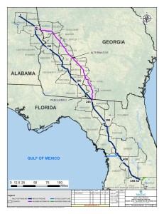
With FERC’s recent instructions to Sabal Trail adding three more pipeline alternates that could go through Lowndes County, Lowndes has become even more of a key county regarding that pipeline. Please see the appended letter signed by many groups and individuals for resolutions and an ordinance that other counties have already passed.
Thanks,
John S. Quarterman, President, WWALS Watershed Coalition, Inc. Continue reading
FL State Rep. Elizabeth Porter objects to FERC about Sabal Trail pipeline in karst limestone
 Chris Mericle’s Florida state rep.,
Elizabeth Porter,
who also attended the recent
GA EPD briefing to SRWMD about Valdosta’s plans to fix
its wastewater overflowes into the Withlacoochee River, just objected to FERC about Sabal Trail’s fracked methane pipeline (PDF).
Chris and Deanna Mericle are our local hosts for the
WWALS Withlacoochee and Suwannee River
paddle past the pipeline 21 September 2014.
Chris Mericle’s Florida state rep.,
Elizabeth Porter,
who also attended the recent
GA EPD briefing to SRWMD about Valdosta’s plans to fix
its wastewater overflowes into the Withlacoochee River, just objected to FERC about Sabal Trail’s fracked methane pipeline (PDF).
Chris and Deanna Mericle are our local hosts for the
WWALS Withlacoochee and Suwannee River
paddle past the pipeline 21 September 2014.
FLORIDA HOUSE OF REPRESENTATIVES
Continue reading
Representative Elizabeth Porter
District 10
Elizabeth.Porter@myfloridahouse.gov
New Georgia law bans riding ATVs in riverbeds.
Terry Dickson and Walter C. Jones wrote for the Florida Times-Union Saturday, May 22, 2010,
New Georgia law bans riding ATVs in riverbeds,

The measure should increase safety and reduce environmental damage.
House Bill 207, Continue reading
Withlacoochee and Suwannee paddle: springs, shoals, and pipeline 21 Sept 2014
Update 20 September 2014: Now with a lunch stop at Chris and Deanna’s house! Bring your own lunch or snacks, but the Mericles have picnic tables and bathrooms. Chris reports the Withlacoochee is high enough that the shoals are no problem, and the weather report says clear all day tomorrow. See also his report on FERC and Sabal Trail’s recent visit to this same area and what Sabal Trail wrote to FERC the next day.
 Sabal Trail may be thinking of moving their pipeline, but WWALS is
still padding past the original location 10AM Sunday September 21st.
All are invited to come see for themselves the springs, shoals, and sinkholes
that we value more highly than pipeline profit for a company from Houston.
Join us for a fine day on two of our fabulous southern blackwater rivers:
the Withlacoochee River and the Suwannee River, in Hamilton and Suwannee
Counties, Florida.
Sabal Trail may be thinking of moving their pipeline, but WWALS is
still padding past the original location 10AM Sunday September 21st.
All are invited to come see for themselves the springs, shoals, and sinkholes
that we value more highly than pipeline profit for a company from Houston.
Join us for a fine day on two of our fabulous southern blackwater rivers:
the Withlacoochee River and the Suwannee River, in Hamilton and Suwannee
Counties, Florida.
The meeting place is the CR 143 Boat Ramp on the Withlacoochee River near Jennings, Florida. For directions, please see the earlier post about this outing.
This event is FREE! All we ask is Continue reading
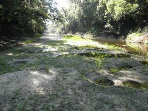
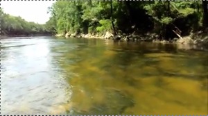
Alapahoochee River @ GA 135/141
 We were out towards Jennings Sept. 1st and stopped at the Alapahoochee River @ Hwy 135/141.
-April Huntley
-

- 720×960 Sign, in Alapahoochee River, by April Huntley, 1 September 2014, Alapahoochee River 9/1/14 @ Hwy 135/141 https://www.facebook.com/Wwalswatershed/posts/562756823851052
-

- 960×720 Narrow, in Alapahoochee River, by April Huntley, 1 September 2014, Alapahoochee River 9/1/14 @ Hwy 135/141 https://www.facebook.com/Wwalswatershed/posts/562756823851052
-

- 960×720 Closer, in Alapahoochee River, by April Huntley, 1 September 2014, Alapahoochee River 9/1/14 @ Hwy 135/141 https://www.facebook.com/Wwalswatershed/posts/562756823851052
-

- 960×720 Red, in Alapahoochee River, by April Huntley, 1 September 2014, Alapahoochee River 9/1/14 @ Hwy 135/141 https://www.facebook.com/Wwalswatershed/posts/562756823851052
-

- 960×720 Muddy?, in Alapahoochee River, by April Huntley, 1 September 2014, Alapahoochee River 9/1/14 @ Hwy 135/141 https://www.facebook.com/Wwalswatershed/posts/562756823851052
-

- 960×720 Very Red, in Alapahoochee River, by April Huntley, 1 September 2014, Alapahoochee River 9/1/14 @ Hwy 135/141 https://www.facebook.com/Wwalswatershed/posts/562756823851052
WWALS signs letter to county commissions opposing the Sabal Trail pipeline
 A citizen of Suwannee County, Florida has written a letter
to county commissions, starting with
her own Suwannee County Commission that meets tonight,
and WWALS Watershed Coalition, Inc. has joined the many signers.
A citizen of Suwannee County, Florida has written a letter
to county commissions, starting with
her own Suwannee County Commission that meets tonight,
and WWALS Watershed Coalition, Inc. has joined the many signers.
The Action letter to County Commissioners against Sabal Trail pipeline begins:
Dear Commissioner,
We are sure that you have heard of the Sabal Trail/Spectra Energy Pipeline and the resolution passed by Hamilton County BOCC August 22, 2014, to prohibit its path through the Withlacoochee River in Hamilton County (link below). It appears that that resolution has been successful. But the problem has not gone away in that Continue reading
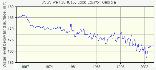
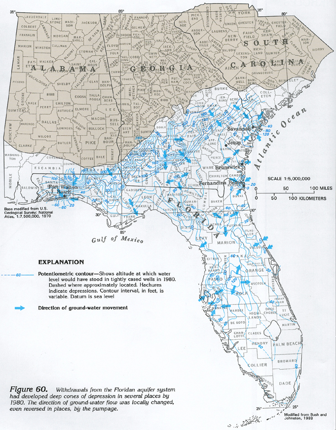
Cook County, GA ground water depletion –USGS
In USGS’s web page on Groundwater depletion:
The chart below shows monthly-mean water levels from 1964 to 2003 for a well in Cook County, sourthwest Georgia. The well is used for irrigation and public- supply purposes and offers a good visual representation of long-term groundwat er declines due to excessive pumping. [d]—data for the chart is available.
West-central Florida— Continue reading
USGS warns Withlacoochee River already leaks into Floridan Aquifer
 There’s a reason
Valdosta’s water wells are 400 feet deep.
Its earlier, shallower wells were sucking up Withlacoochee River water that still leaks into groundwater.
Should we risk a fracked methane pipeline digging under that same river and possibly causing more sinkholes and underground movement of contaminants, some perhaps coming from the pipeline itself or its demands for pressure testing water?
There’s a reason
Valdosta’s water wells are 400 feet deep.
Its earlier, shallower wells were sucking up Withlacoochee River water that still leaks into groundwater.
Should we risk a fracked methane pipeline digging under that same river and possibly causing more sinkholes and underground movement of contaminants, some perhaps coming from the pipeline itself or its demands for pressure testing water?
Sustainability of Ground-water Resources, by William M. Alley Thomas E. Reilly O. Lehn Franke, 1 January 1999, U.S. Department of the Interior, U.S. Geological Survey – Publisher. In Box E on Page 63:
The Connection Between Surface-Water Quality and Ground-Water Quality in a Karst Aquifer
The Upper Floridan aquifer, which is the sole source of water supply for Valdosta, Georgia, and much of the surrounding area, receives large volumes of direct discharge from the Withlacoochee River through sinkholes in the streambed or off-channel. A highly interconnected conduit system has developed Continue reading
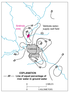
Figure E-1. Estimated percentage of Withlacoochee River water in ground water in the Upper Floridan aquifer, June 1991. (Modified from Plummer and others, 1998.)