This is why WWALS recommends filing a float plan, or in this case, a hiking and camping plan.

WALB News Team, 17 January 2016, Campers rescued from rising floodwater, warning issued,
BERRIEN CO., GA (WALB) – The Berrien County Sheriff is sending a warning to residents to stay off the Alapaha River.
“Its not a good time to be camping out on the river,” said Sheriff Anthony Heath.
About 11 a.m. on Sunday, four Berrien County campers had to be rescued after they were surrounded by rising floodwaters. A father, his daughter, son, and son’s girlfriend hiked downstream and set up camp at the Alapaha River bridge near state Route 135, south of Willacoochee.
The VDT says they camped on Saturday, and were found the next day. Terry Richards, Valdosta Daily Times, 19 January 2016, page 8A, Stranded campers réscued,
When they didn’t return home, someone called the sheriff’s department and Sgt. Roger Purvis located their vehicle next to the bridge but didn’t see anyone, the sheriff said.
A passing “good Samaritan” with a boat stopped when he saw the deputy’s car by the bridge and offered to help. The deputy and the resident headed out on the river in the boat, and 30 minutes later they located the campers, Heath said.
Then trouble struck again. The boat’s motor tailed. leaving the campers, the deputy and the good Samaritan stranded, the sheriff said.
Purvis radioed the situation in. and both the Department of Natural Resources and Berrien County Search and Rescue came to the scene. A DNR boat was used to bring everybody to safety the sheriff said.
No one was injured in the incident, Heath said. He thanked Berrien County Search and Rescue and the DNR for their assistance, and asked the public to be mindful of where the river is and of rainfall predictions when hiking.
Thanks to Julie Bowland for spotting the VDT story.
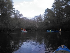
 The area described was near
the area pictured above from the
WWALS Outing of 14 March 2015,
when the water level on the USGS gauge at US 82 east of Alapaha, GA was a little over 9 feet.
This Saturday it was about 9.8 feet, and you can see the level jumped up in the previous day.
That rise also would have taken a day or so to come down the river the
almost 19 miles from US 82 to GA 135,
so what the campers probably experienced was a rise of almost half a foot
such as shows for the Alapaha gauge between Friday morning and Saturday mid-day.
Half a foot vertically can turn a sand bar into an island, such as what apparently happened.
 Even faster rises and drops in the water level happen, as you can see by the graph of 365 days through 2015 until today.
So before hiking, camping, or boating on the Alapaha River, please
check
the gauges, especially upstream, check the weather report, and
file a
float plan.
-jsq
You can join this fun and work by becoming a WWALS member today!
Short Link:
