Update 2016-03-31: Rescheduled for Ray’s Mill Pond, due to flood stage on the Withlacoochee River.
Back on the Withlacoochee River in Valdosta,
by popular demand from last weekend’s outing!
 We’ll continue next weekend on the next leg down the Withlacoochee River
on the
Withlacoochee and Little River Water Trail.
When: 9AM Sunday April 3rd 2016
Put in:
Langdale Park Boat Ramp,
Langdale Park, Hyta Mederer Dr, Valdosta, GA 31602
Yes, we know Langdale Park is closed.
Thanks to George Page, Executive Director of Valdosta-Lowndes County Parks and Recreation Authority for agreeing to let us in anyway.
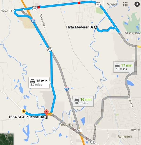
 Directions: Take I-75 exit 22 towards Valdosta on North Valdosta Road (US 41), turn right just past the Withlacoochee River at the Langdale Park sign onto Hyta Mederer Drive, continue to the boat ramp.
Take out: Little River Boat Ramp
Distance: 5 miles downstream to the Little River Confluence, and about 1 third of a mile upstream to the takeout.
Goes by: Three Mile “drains Five Points” Branch, Sugar “hold your nose” Creek, under the GSF “Suwannee River Route” Railroad bridge, past several VSU professors’ houses, under I-75 and GA 133, past Troupville (the predecessor to Valdosta), paddle right at the Little River Confluence, paddle up the Little River about a third of a mile, and get out at the Little River Boat Ramp next to the state prison.
Shuttle: 10 miles or 15 minutes each way, 45 minutes total.
Responsible party: Chris Mericle
Local Host: John Quarterman
Too high: flood stage is 15 feet
at US 41. The chart on the right is live, so see for yourself.
This outing is Free! But we encourage you to join WWALS today to support our fun outings and important work: /donations/. See our newsletters, and the press Releases and news. And consider joining the Withlacoochee and Little River Water Trail Committee.
Backup in case of low or high water:
Where: Ray’s Millpond, 875 Rays Mill Pond Rd., Ray City, GA 31645
When: 9AM March 20th 2016
Directions: From Valdosta, north on Bemis Road (GA 125) to Ray City, right on Jones St. to boat ramp.
And we hope to see you at more upcoming WWALS outings and events.
-jsq
You can join this fun and work by becoming a WWALS member today!
Short Link:


Pingback: WWALS Outings and Events late 2015 – early 2016 | WWALS Watershed Coalition
Pingback: Three more Valdosta wastewater overflows 2016-03-28 | WWALS Watershed Coalition
Pingback: Withlacoochee River US 41 just before flood, 2016-03-31 | WWALS Watershed Coalition