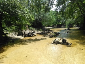
My phone’s pedometer said I walked four miles of the six miles of this section of the Little River, with many fish, two white birds, lots of sand bars, some eroded bluffs, not a lot of trash after we got beyond the GA 76 bridge, and only one spot of invasive species (Japanese climbing fern).
This section would be better with about half a foot more water. The USGS GA 122 Little River gage showed about 3.71 feet for July 10th 2016, so let’s say at least 4.2 feet would be good. This is because there are many sand bars, including one directly upstream from the GA 122 bridge, where the water level is much closer to zero when that gage says 3.71.
Following up a report, Phil Hubbard and John S. Quarterman boated (and walked) from Cook County Landing at GA 76 down to GA 122. This is about 5.9 river miles, which should take about three hours to paddle. We put in about 9:20 AM and took out about 1:45 PM, so that’s around 4 and a half hours on the river. Not a bad way to spend a summer morning on the Withlacoochee and Little River Water Trail.
Below are small images of many pictures. Click on any small picture to get a bigger picture.
At the end there’s a google map/a> with links to pictures.
Plus on YouTube there are a couple of brief videos.
-jsq
You can join this fun and work by becoming a WWALS member today!
Follow
this link for a google map with links to the pictures.
Or use the copy embedded below.
Short Link:
Public Boat Ramp, DNR, Wildlife Resources Div., 31.0427856, -83.4922790

Little River at Cook County Landing, 31.0396538, -83.4930725

Beach, 31.0376606, -83.4916458

Trash, 31.0376606, -83.4916458

Rope swing, 31.0376606, -83.4916458

Beach again, 31.0372314, -83.4915848

Phil Hubbard on the rocks, 31.0367164, -83.4915390

Movie: Sand, rocks, and river (1.3M)

Tannic tea-colored river water

Movie: Phil about to get out of his boat (1.7M)

Table leg stuck in river bottom, 31.0366535, -83.4910660

Table leg2, 31.0366535, -83.4910660

Narrow tea-colored river water, 31.0367622, -83.4905166

Phil still floating, 31.0367622, -83.4905166

Phil at a creek, 31.0355380, -83.4897100

Creek coming from Brooks County, 31.0355377, -83.4897003

Culvert or tires in creek? 31.0354824, -83.4896698

Heading downstream, 31.0354824, -83.4896927

Sun and shade 31.0321693, -83.4791500

Phil gliding along, 31.0349960, -83.4847270

Narrowing, 31.0349960, -83.4847259

Trash under deadfall, 31.0339432, -83.4834061

Beer can in bottom, 31.0340290, -83.4832611

Nice water color; could use more of it, 31.0334721, -83.4834900

Bottom furrows, 31.0334892, -83.4834747

Deadfall tunnel, 31.0329132, -83.4822693

Phil trying to float past sand bar, 31.0321693, -83.4791489

Angled deadfall, 31.0322208, -83.4777984

Yellow tea water, 31.0322037, -83.4778137

More yellow water, 31.0322037, -83.4778137

Tangled deadfalls below Pine Bluff

Striated bottom, 31.0319328, -83.4755783

Tracks on the bottom? 31.0319328, -83.4755783

More bottom tracks, 31.0319328, -83.4755783

Phil walking in boat, 31.0312614, -83.4771423

More bluff downstream, KIMG6092 31.0312600, -83.4771495

Eroded neck of Pine Bluff, 31.0312710, -83.4771423

Bluff right, 31.0312824, -83.4771194

Pine Bluff neck panorama, 31.0312824, -83.4771199

Phil heading downstream from Pine Bluff, 31.0312824, -83.4771199

Phil on around the bluff, 31.0312519, -83.4771499

Phil around the bend, 31.0306682, -83.4767303

The bend, 31.0306606, -83.4766464

Deadfall wedged in live trees, 31.0307560, -83.4765243

Green between, 31.0307560, -83.4765243

Phil dragging boat, 31.0314751, -83.4734649

Fish bed just above Wells Mill Creek, 31.0309906, -83.4735107

Closeup fish bed, 31.0310821, -83.4734497

Fish above fish bed, 31.0311069, -83.4735412

Frothy fish bed, 31.0310802, -83.4735412

Bottom ripples below fish bed, 31.0310802, -83.4735412

Fence below bluff, 31.0296612, -83.4736786

Yellow bottom, 31.0298271, -83.4732056

Fish swimming, 31.0298271, -83.4732056

Phil made it through the narrows, 31.0297718, -83.4731521

Tire on sand bar, 31.0291042, -83.4728699

Phil walking his boat, 31.0290565, -83.4728622

And a bend to the right, 31.0294830, -83.4724884

Boat floating by itself, 31.0294838, -83.4724884

Trash by log, 31.0295086, -83.4725036

Fish bed below log, 31.0282650, -83.4706650

Bottle on sand, 31.0282650, -83.4706650

Log across, 31.0297832, -83.4688034

Right bank sand over log, left bank eroded bluff, 31.0297756, -83.4687881

Tree in stream, 31.0285358, -83.4682312

Tree, tea colors, 31.0285339, -83.4682464

Phil turning to the left, 31.0283546, -83.4695650

Bluff, fence, and clouds, 31.0283546, -83.4695663

Left sand bar, Phil, right bluff with fence, 31.0279910, -83.4699114

Fallen fence posts, 31.0279910, -83.4699110

Phil poling through, 31.0269623, -83.4698334

Fence posts barely hanging on the bluff

Sand becomes woods, 31.0246610, -83.4711400

Building on bluff, 31.0246620, -83.4711456

Rope in boat, 31.0246658, -83.4711075

Japanese climbing fern below building

Closeup, Japanese climbing fern, 31.0236664, -83.4716339

Broken outdoor oven in river, 31.0236664, -83.4716339

Right around the sand, 31.0344444, -83.4766667

Phil below the blazing sand bluff, 31.0344444, -83.4766667

Apparently only native vegetation, 31.0217037, -83.4679031

Tangled deadfalls, 31.0212288, -83.4678268

Phil surveys the tangles, 31.0212097, -83.4678039

Phil under a downed tree, 31.0203390, -83.4671020

Under the tree, 31.0203388, -83.4671020

Branch sawed off, 31.0203382, -83.4671020

Sawed branch in water, 31.0203381, -83.4671020

House on left bank, 31.0197760, -83.4666290

Left bank house, 31.0197754, -83.4666290

Green glare, 31.0196438, -83.4665680

Looks like clear boating, 31.0192833, -83.4663849

Phil below a left bank bluff, 31.0159820, -83.4668770

Paddling to the left, 31.0161343, -83.4673843

Sign on tree, 31.0168018, -83.4682541

Small dry creek? 31.0168018, -83.4682541

Sharp left bend, 31.0125960, -83.4663840

Many deadfalls, 31.0124400, -83.4661090

Two birds, 31.0123615, -83.4660034

Two birds closeup, 31.0123615, -83.4660034

Phil boating again, 31.0086918, -83.4645157

Same birds farther down, 31.0075207, -83.4634476

Meetinghouse Branch Keep Out, 31.0071650, -83.4625270

Keep Out Meetinghouse Branch, 31.0071650, -83.4625270

Just enough water here, 31.0016918, -83.4573364

GA 122 bridge in sight, 31.0012350, -83.4571120

Cook County Landing, 31.0401115, -83.4931030

DeWitt Farms, No Trespassing, 31.0278320, -83.4811859

Vegetables bedded, 31.0198326, -83.4770889

Blease Road Closed, Bridge Out, 31.0062675, -83.4715271

Little River Groceries, 8235 GA 122, Hahira, GA 31632, 30.9969597, -83.4403229
Google Map


