Apparently that wet area I saw March 20, 2017 at Sabal Trail’s Suwannee River HDD access in Suwannee County was a “depression” they had just logged the previous day. Two more recent ones show up in Sabal Trail’s latest bi-weekly report, along with a couple of earlier ones they still haven’t even attempted to fix. Why should we expect these sinkholes will stop happening if Sabal Trail finishes and takes all their workers back to Houston, leaving us to deal with the damage?
 I also wondered what they were up to a bit southeast of that drill site,
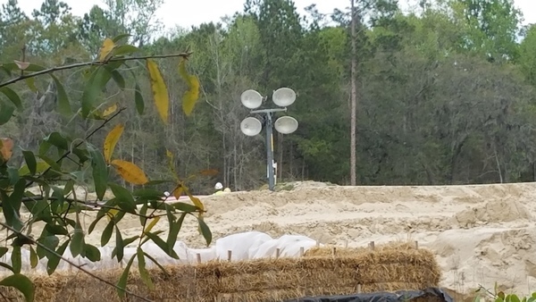
beyond the dirt berm where I could only see their heads and hats.
Apparently that was another sinkhole from January at the
Suwannee River HDD in Suwannee County.
Or maybe it was in Hamilton County in Suwannee River State Park;
their description is so sloppy it’s hard to tell.
They also made a sinkhole a couple of thousand feet east of the Withlacoochee River in Hamilton County, and yet another sinkhole near the Santa Fe River HDD. The big winner is the Flint River HDD site with five sinkholes, although Sabal Trail tries to rationalize that as maybe two of them were already there.
This is all without Sabal Trail acknowledging in their most recent bi-weekly report all the previous karst limestone problems they’ve caused, such as the frac-out under the Withlacoochee River in Georgia and the sinkhole at the Lowndes County Withlacoochee River HDD site.
These recently-reported sinkholes are just more examples of how Sabal Trail violations FDEP assured us would not happen are happening.
There are still things you can do to stop this completely unnecessary pipeline boondoggle and get on with solar power for jobs, profit, and oh, clean water and air as well.
DEPRESSION FEATURES AND MITIGATION LOG
FERC Accession Number: 20170505-5043, “Sabal Trail Transmission, LLC submits its biweekly status report for the Sabal Trail Project under CP15-17.”Interpreted by Suwannee Riverkeeper 2017-05-08
Includes:- Flint River sinkholes
- Withlacoochee River sinkhole
- Suwannee River HDD
- Suwannee River RoW
- Santa Fe River HDD
Flint River sinkholes
Spread: 2
MP: 162.7 – 163.1
Type: HDD
Date Identified in Field: 10/27/2016
Karst Feature Description: Flint River HDD — Five (5) locations of depressions were noted during the HDD activities between the road and the river. Following the heavy rains of 11/28 and 11/29/2016 noted two (2) additional locations, with some increase in depth of the other locations. Two (2) of the locations may be possible pre-existing depression areas.
Comments: GeoEngineers monitored during HDD. PSI performed a visual evaluation of the locations on 12/9/2016.
Final Mitigation Required: Remediation recommendations are as specified in the Karst Mitigation Plan. Working with the landowner and appropriate agencies to address access and the mitigation process. Access to the area hindered by the river water level. Water receding and starting to gain access.
WWALS Interpretation
Approx. GPS: 31.5015, -84.15308
Approx. address: 3620 Victory St, Albany, GA 31721
About:
Sabal Trail Alignment Map: Sabal Trail alignment map 1657-PL-DG-70197-164
Withlacoochee River sinkhole
Spread: 3
MP: 250.42
Type: RoW
Date Identified in Field: 12/17/2016
Karst Feature Description: Depression 50’x50′ by approximately 15′ deep, in the temporary workspace area.
Comments: Placed safety fence around the location and will monitor for any changes.
Final Mitigation Required: Will work around the area and monitor as part of the routine observations. A mitigation plan will be developed as part of final cleanup.
WWALS Interpretation
Approx. GPS: 30.609722, -83.257621
Approx. address: 956 NW 16th Ave, Jennings, FL 32053, in Hamilton County.
About: That’s a few thousand feet east of the Withlacoochee River, and south of the Oak Grove Missionary Baptist Church.
Sabal Trail Alignment Map: 1657-PL-DG-70197-252
Suwannee River HDD
Spread: 3
MP: 265.64
Type: HDD
Date Identified in Field: 1/11/2017
Karst Feature Description: Suwannee River HDD — A depression developed approximately 165 feet southeast of the HDD exit point generally along the pipeline alignment.
Comments: The area was temporarily covered with timber mats. GeoEngineers monitored during the HDD operations. As the HDD operations were installing the pipe, the depression grew and action was taken to fill the depression and keep it from growing.
Final Mitigation Required: Used the method of lifts of sand and water to fill the depression up to one foot from surface. Used soil to complete the filling and mound over the top to enhance water runoff. The area will continue to be visually monitored during construction.
WWALS Interpretation
Approx. GPS: 30.406772, -83.153221
Approx. address: North of the Sabal Trail entrance at 24th St, Live Oak, FL 32060, and left around the corner.
About: Sabal Trail’s quoted mile marker makes no sense. MP 265.64 is significantly west of either Suwannee River HDD site.
Sabal Trail Alignment Map: 1657-PL-DG-70197-271
If they mean 165 feet southeast of the Hamilton County HDD site, that would be right at the corner of Suwannee River State Park, and I believe I or many other visitors would have seen it on one of the several occasions since their stated discovery date.
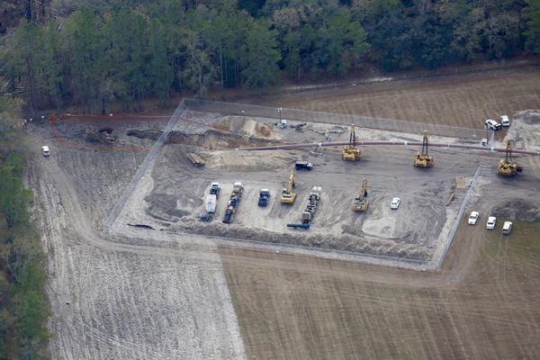
Maybe they meant 165 feet northwest of the Hamilton County HDD exit, where there certainly was what looked like a sinkhole you can see between some sheriff vehicles and the pipe in this aerial of 14 January 2014, and there are plenty of other candidates “>farther along the Sabal Trail right of way in Hamilton County, including near the CR 141 Troy Access, shown in aerials taken that same day by Beth Gammie for WWALS on a Southwings flight.

S to pipe going into ground, with a few Sheriff vehicles 12:47 PM, 30.4116960, -83.1661320
If they mean 165 feet southeast of the Suwannee County HDD site, even though that is marked as HDD Entry, not HDD Exit on their alignment map, that would be barely still in Spread 3 and would be about where I observed Sabal Trail working last month. So that’s the location I’ve guessed.
That location matches where on 20 March 2017 I saw Sabal Trail and contractor heads and hats across their dirt berm:

Hay, berm, lights, workers 30.4061111, -83.1527778
With a little help from some friends, we could see over that berm five weeks earlier, February 12, 2017, and it sure looked like a sinkhole there:

Pipe not connected? 30.4063022, -83.1529089
According to Sabal Trail’s “Date Identified in Field”, that sinkhole was already there when hundreds of people were protesting on January 14, 2017.
Suwannee River RoW
Spread: 4
MP: 268.7
Type: RoW 4/19/2017
Karst Feature Description: Depression formed on edge of ROW and adjacent to ROW in area away from the excavations. The two depressions measured 22 feet in diameter and 12 feet in diameter with a depth of 5 to 6 feet.
Date Identified in Field: 4/19/2017
Comments: PSI reviewed the location for mitigation on 4/21/2017. Recommendation was to fill in the depressions in accordance to the Karst Mitigation Plan. Monitored the area while permissions obtained for the off right-of-way portion.
Final Mitigation Required: Received approvals for off right-of- way portion on 4/29/2017. Will use the method of lifts of sand and water to fill the depression up to one foot from surface. Will use soil to complete the filling and mound over the top to enhance water runoff.
WWALS Interpretation
Approx. GPS: 30.404190, -83.151996
Approx. address: Between the Sabal Trail entrance at 24th St, Live Oak, FL 32060 and the Suwannee River HDD site in Suwannee County.
About: Where lines of law enforcement were standing in January during the protests.
Sabal Trail Alignment Map: 1657-PL-DG-70197-271
This is apparently the area I photographed 20 March 2017:

Squared off logs covering wet area 30.4025000, -83.1525000
Santa Fe River HDD
Spread: 4
MP: 311.42
Type: HDD
Date Identified in Field: 3/14/2017
Karst Feature Description: Santa Fe River HDD — A new subsidence area observed in undisturbed area over centerline of the HDD at Station 16443+00, 25 feet beyond the cleared area on the permanent easement. The size is approximately 10 feet x 8 feet and 8 feet deep.
Comments: Monitoring the area. Reviewed the area with the FLDEP. Recommendation to fill the depression.
Final Mitigation Required: Mitigation accepted by FLDEP. Completed.
WWALS Interpretation
Approx. GPS: 29.909564, -82.851369
Approx. address: 2410 NW 117th Pl, Branford, FL 32008
About: This is the most precise address Sabal Trail supplied for any of these “depressions”.
Sabal Trail Alignment Map: 1657-PL-DG-70197-314
Thanks to Janet Barrow for spotting these “depressions” in Sabal Trail’s most recent bi-weekly report.
-jsq, John S. Quarterman, Suwannee RIVERKEEPER® You can join this fun and work by becoming a WWALS member today! Short Link:

Pingback: Natural Gas is Going Down Like Coal and Kodak: Let the Sun Rise! – Progress For All
Pingback: Sabal Trail sign installation at SRSP, 2017-05-19 | WWALS Watershed Coalition (Suwannee RIVERKEEPER®)
Pingback: Suwannee County HDD, Sabal Trail, 2017-05-20 | WWALS Watershed Coalition (Suwannee RIVERKEEPER®)