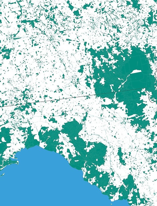
Obviously nobody lives in most of the Okefenokee Swamp or the Osceola National Forest, but also most of Clinch County is unpopulated west of the Swamp, as is much of the Gulf coast along the Suwannee River Estuary, from Cedar Key north to Horsehoe Bay, plus large parts of Dixie and Lafayette Counties west of the Suwannee River.

Nobody Lives Here:
Unpopulated U.S. Census Blocks,
screenshot by jsq from interactive map by
mapsbynik.
Update 2017-06-20: As someone pointed out, rangers do live in the Okefenokee Swamp, presumably in the white area along the access road.
Cedar Key is the island at the bottom of the map, and from a bit north on the Gulf Coast you can follow the Suwannee River upstream all the way to the Okefenokee. East of Twin Rivers State Forest and Suwannee River State Park, Live Oak and Lake City are pretty easy to spot because I-10 is visible. Valdosta and Tifton similarly are on north-south I-75, with major cross highways (US-84 and US-82), plus each has an airport south of it. In Georgia, the Little and Withlacoochee Rivers are pretty easy to see, with the Alapaha more thready.
Mapsbynik explains:
A Block is the smallest area unit used by the U.S. Census Bureau for counting statistics in the United States. As of 2010, the U.S. consists of 11,078,300 Census Blocks. Of them, 4,871,270 blocks totaling 4.61 million square kilometers were reported to have no population living inside them. Despite having a population of more than 310 million people, no one calls 47 percent of the USA “home”.
Green shading indicates unoccupied Census Blocks. A single inhabitant is enough to color a block white.
Which is presumably why the Alapaha WMA doesn’t show up as green: it probably doesn’t occupy an entire census block. Hm, or maybe it is green on this map: I think I see it northeast of Tifton. More obvious (to me) is Grand Bay WMA and Banks Lake northeast of Valdosta.
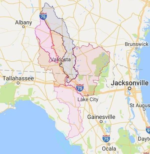
Compare to this map of WWALS watersheds:

The watersheds shown are for these Hydrologic Unit Codes (HUCs):
- HUC 03110203: Withlacoochee River
- HUC 03110204: Little River
- HUC 03110202: Alapaha River, including Willacoochee River
- HUC 03110201: Upper Suwannee River
- HUC 03110205: Lower Suwannee River
- Suwannee River Estuary
Not every green area is wild. Much of Clinch County is planted pine plantations, with some blueberry and other farms. But many of these green areas are pretty wild.
These empty quarters are a good thing, I think. Wildlife and vegetation can be more or less natural, and we still get to go look and paddle, and often also to hunt and fish.
-jsq, John S. Quarterman, Suwannee RIVERKEEPER®
You can join this fun and work by becoming a WWALS member today!
Short Link:
