Here’s an update on the draft brochures for both WWALS Water Trails, after the recent meeting of the WWALS Water Trails Committee. We could still use more pictures.
Please email pictures to wwalswatershed@gmail.com. Please say who took each picture, when, where, and of what. High resolution, please.
If you want to join the WWALS Trails Committee to help continue organizing this work, actually editing the documents shown below, you must be a WWALS member and apply.
What
The Trails Committee is working on brochures for the Alapaha River Water Trail (ARWT) and the Withlacoochee and Little River Water Trail (WLRWT).
You’ll notice some common features for the two brochures. Each is to be printed on 11×17 inch (tabloid) size paper in a z-fold. Tabloid is the size of an unfoled newspaper page.
Both have a trail description and text about safety, etiquette, water quality testing, and the WWALS mission, plus logos for the water trail (that one top of the front cover), and for WWALS, Suwannee Riverkeeper, Waterkeeper Alliance, and Georgia Water Trails, plus a QRcode.
One whole side is taken up with a list of access points and a water trail map.
Both have many pictures, and we could use more.
Last but not least, there is a list of sponsoring organizations. We could always use more sponsors.
Many of those features are required to be a Georgia Water Trail. Other requirements are road signs and signs at (at least two) landings (almost done), and online web pages and maps (been done for years). These brochures are pretty near the last requirements.
While we can design them any way we want to, for simplicity so far we are pretty much copying the original ARWT brochure design by our graphics designer Donna Delaney. She will do the final formatting. What you see here are mockups in google docs.
Alapaha River Water Trail (ARWT)
See the ARWT web page for details on this first WWALS water trail.
See also the pictures of the original ARWT brochure from 2015. Two printings totalling 10,000 copies are distributed up and down I-75 in Georgia and Florida, bringing people to the ARWT from as far as Ottawa and south Florida.
The second printing of 5,000 copies is subtly different in several ways, including changes to the WWALS Mission, and in having down at the bottom left of the cover side:
Brochure: Funded by Hamilton County TDC
Design: ImageDoctor.org
drdelane@gmail.com
We can omit that TDC this time, because Hamilton County is doing its own all-in-one brochures for everything about that county.
The paper used so far is shiny and durable, and that’s good. However, people think it’s waterproof, but it’s not. Actually, if you get it wet, it melts together and is unusable. This time we should spring for waterproof paper.
Many things have changed since the second printing of the ARWT brochure, such as WWALS now has a license for Suwannee Riverkeeper® and we’ve made many changes to the ARWT map and underlying spreadsheet. For examples, the names of several access points have changed, and we’ve discovered an additional one.
The ARWT brochure is printed on 11×17 inch (tabloid) size paper in a z-fold.
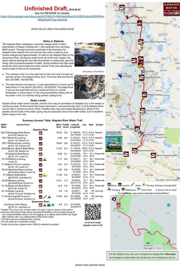
Effectively there are three sides, as detailed below: ARWT Coverside, ARWT Backside, and ARWT Mapside.
ARWT Coverside, ARWT
This image was made from the current google doc.
ARWT Backside, ARWT
This image was made from the current google doc.
ARWT Mapside, ARWT
This image was made from the current google doc.
Obviously the map could use some work. One way to deal with the scale issue (how do you show close-spaced landings on a map of the entire water trail?) is to add inset maps for places such as Lakeland, Hotchkiss Road, and north Florida (added).
Withlacoochee and Little River Water Trail (WLRWT)
See the WLRWT web page.
We don’t have a WLRWT brochure yet, so see the 8.5×11 inch trifold WLRWT pamphlet.
We have $500 from Valdosta-Lowndes Tourism Authority to print a brochure. We want to print a WLRWT brochure on 11×17 inch (tabloid) size paper in a z-fold. That will cost somewhat more than $500, so we can always use more sponsors.
Effectively there are three sides, as detailed below: WLRWT Coverside, WLRWT Backside, and WLRWT Mapside.
WLRWT Coverside, WLRWT
This image was made from the current google doc.
WLRWT Backside, WLRWT
This image was made from the current google doc.
WLRWT Mapside, WLRWT
This image was made from the current google doc.
Obviously the main map still needs more work. The biggest issue is trying to show all the landings on one map, when some of them are so close together they can’t show up at that scale. The solution hinted at by the small maps (center right and bottom left) is to use inset maps.
-jsq, John S. Quarterman, Suwannee RIVERKEEPER®
You can join this fun and work by becoming a WWALS member today!
Short Link:


