
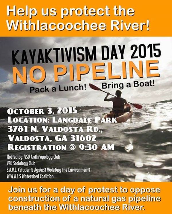
Come paddle the idyllic Withlacoochee River in its most urbanized area, Valdosta,
 help clean up trash, and do kayaktivism against the Sabal Trail fracked methane pipeline, which would cross only a few miles downstream.
This is a WWALS Field Trip from Langdale Park upstream to the North Valdosta Road Bridge, Saturday morning October 3rd 2015, in support of
the VSU Anthropology Club, the VSU Sociology Club, and
Students Against Violating the Environment (S.A.V.E.),
who invite you to Kayaktivism Day 2015!
help clean up trash, and do kayaktivism against the Sabal Trail fracked methane pipeline, which would cross only a few miles downstream.
This is a WWALS Field Trip from Langdale Park upstream to the North Valdosta Road Bridge, Saturday morning October 3rd 2015, in support of
the VSU Anthropology Club, the VSU Sociology Club, and
Students Against Violating the Environment (S.A.V.E.),
who invite you to Kayaktivism Day 2015!
If I’m not mistaken, Keep Lowndes/Valdosta Beautiful (KLVB), which is having its annual Rivers Alive cleanup the same day, will send some volunteers to the same site at 8:30 AM, so come early and help clean up!
 Clean up: 8:30 AM on land
Paddle: 9:30 AM registration
Date: Saturday, October 3rd 2015
Where: Langdale Park, 3781 North Valdosta Road, Valdosta, GA 31602
What: First pick up trash, then paddle upstream, lunch near the N. Valdosta Road (US 41) bridge, and paddle back down.
Duration: For the paddle, it took us about an hour yesterday Friday, and we were really dawdling. Add in lunch, and maybe an hour and a half, or call it two hours for time for registration first.
Leader: Ashlie Prain
Facebook: Event
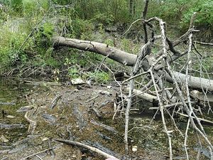
Deadfalls: Who’s in charge of removing those?
Water Level: Hovering just below 4 feet on the USGS gage on the US 41 bridge. If it gets lower, there will be more portaging, unless somebody will take responsibility for removing those deadfalls.
Backup Plan: There is none. This is a Field Trip, not a WWALS Outing, so if there’s massive rainfall we’ll cancel.
The formal WWALS Outing for this month is Sullivan Launch to Blue Spring, Withlacoochee River Outing 2015-10-24. Y’all come!
 The access point for Kayaktivism this Saturday,
Langdale Park Boat Ramp,
is one of the access points for the
Withlacoochee and Little River Water Trail.
It’s about ten miles upstream from
US 84
and where Sabal Trail wants to cross.
For pictures there, see previous post.
The access point for Kayaktivism this Saturday,
Langdale Park Boat Ramp,
is one of the access points for the
Withlacoochee and Little River Water Trail.
It’s about ten miles upstream from
US 84
and where Sabal Trail wants to cross.
For pictures there, see previous post.
Just upstream from US 84 is where the Georgia DNR board last Wednesday gave away an easement to Sabal Trail. It’s not final unless the legislature approves it, and it’s useless if Sabal Trail doesn’t get some other permits.
Don’t forget the FERC meeting about Sabal Trail 6PM Wednesday 30 Sep 2015 at the Holiday Inn, 1805 West Hill Ave., Valdosta, GA 31601. Other nearby FERC meetings are Monday in Albany, Tuesday in Moultrie, and Thursday in Lake City, FL.
And don’t forget the hearing 19-22 October 2015 in Jasper or Live Oak, Florida in which WWALS is fighting for the Suwannee River and the Floridan Aquifer against a permit the FL-DEP proposes to issue. You can support that legal work directly by contributing to the WWALS IndieGoGo crowdfunding campaign.
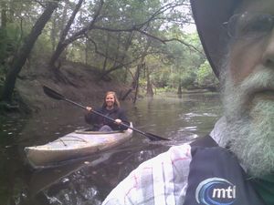
Yesterday Friday Ashlie and I paddled the route for next Saturday’s kayaktivism. Click on any of the pictures below for a larger version.
-jsq
You can join this fun and work by becoming a WWALS member today!
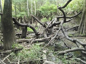
Deadfall just above boatramp 30.8875542, -83.3240433
Lowndes County says GA DNR is in charge of removing deadfalls.
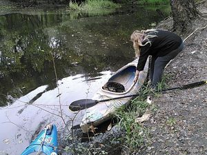
Looks better here 30.8875542, -83.3240433
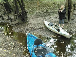
So we went to the other side of the parking lot.
A bit steep, but we can manage 30.8875542, -83.3240433
We’ll probably string a rope or something to make it even easier.
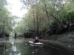
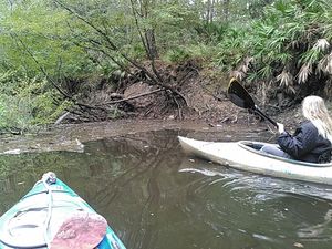
Boating upstream 30.8882561, -83.3236465
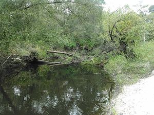
Another deadfall 30.8880958, -83.3233032
Really, who’s in charge of removing deadfalls?
Not too hard to paddle around the end 30.8883571, -83.3230819
And we can probably remove much of that loose stuff by wading with boots and gloves.
And another deadfall 30.8883571, -83.3230819
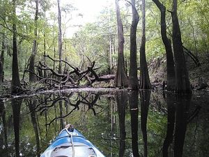
No problem; easy portage 30.8905258, -83.3210907
Well, this one is fun to go around, at least.
Who is responsible for deadfalls in the Withlacoochee River? 30.8907604, -83.3211441
These logs seem to have been piled up here for quite a while. Can we get them moved before next Saturday?
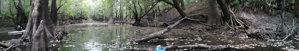
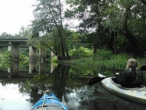
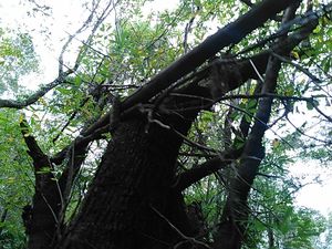
The bridge in sight 30.8907604, -83.3211441
Driving over that bridge on the busiest highway into Valdosta, you hardly notice the river. Looking up from the river, it’s actually quite a bridge.
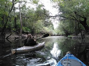
Coming back down 30.8930855, -83.3184128
Langdale Park actually is just outside Valdosta in Lowndes County. But above the bridge on the east, to the left in this picture, is the Country Club, which is inside the Valdosta City Limits. The Withlacoochee River is the city limit right here.
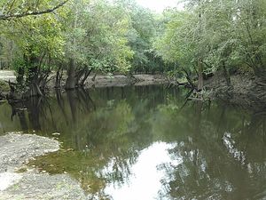
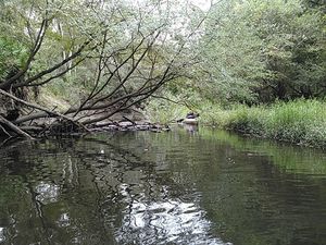
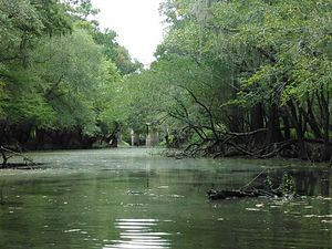
Idyllic river 30.8922405, -83.3192901
Just a few miles from I-75, right next to the biggest city in the entire Suwannee River Basin.
Looking back up to the bridge 30.8911762, -83.3201141
A tad greenish, but pretty good.
The water has been higher 30.8910694, -83.3201599
As in it was
15 feet higher just last December.
Above the deadfall at the boat ramp 30.8907566, -83.3207550

Can move the little stuff; need saw for main log 30.8875008, -83.3240890
Seems like some of our tax-supported local governments could take care of this.
But deadfalls or no, next Saturday is Kayaktivism Day!
Short Link:
Pingback: Withlacoochee River, Langdale Park. | WWALS Watershed Coalition
Pingback: Boat ramp at Langdale Park. | WWALS Watershed Coalition
Thank you, John! This is great!
Pingback: Three FERC Sabal Trail meetings in WWALS territory: Moultrie, Valdosta, Lake City, Sept. 29,30, Oct 1 2015 | WWALS Watershed Coalition
Pingback: Sabal Trail bad for VSU, rivers, animals, landowners, and community: to FERC in Valdosta 2015-09-30 | On the LAKE front
Holy cow, a couple of guys (or good ol’ farm girls) with chainsaws and one afternoon and ya’ll could have that deadfall situation resolved.
Or you could keep complaining to the gooberment, which in my experience is about the least effective way of getting anything done. DNR can’t pay for half the things they need to be doing, and are wanting to raise hunting/fishing license fees again. I doubt a downed tree in a mostly non-navigable waterway is high on their priority list. Up here on the Ocmulgee if you need to get around a bad deadfall you can cut it up yourself or sit there waiting on somebody else to come along and do it for you, in which case you might be waiting a long time.
A couple of guys with a chainsaw did clear a path.
Meanwhile, county mowers came by and made land access easier.
Local citizens and local government working together!
The big deadfalls still need to be removed.
Despite what the county says, I’m pretty sure it’s their responsibility,not DNR’s. We shall see.
One of the reasons a watershed organization such as WWALS exists is to get local governments to do water-related things they should be doing anyway, ranging from explaining the Valdosta wastewater situation to the county building a boat ramp to clearing deadfalls.
-jsq