 First a $250 check, then a letter of support, from the Hamilton County, Florida
Tourist Development Council (TDC).
WWALS thanks TDC!
First a $250 check, then a letter of support, from the Hamilton County, Florida
Tourist Development Council (TDC).
WWALS thanks TDC!
In this picture taken at the 26 October 2014 Dead River Sink Outing Continue reading

First a $250 check, then a letter of support, from the Hamilton County, Florida
Tourist Development Council (TDC).
WWALS thanks TDC!
In this picture taken at the 26 October 2014 Dead River Sink Outing Continue reading
 WWALS Watershed
Coalition, Inc.
WWALS Watershed
Coalition, Inc.
a 501(c)(3) nonprofit corporation
3338 Country Club Road #L336
Valdosta, GA 31605
17 November 2014
Re: Alapaha River Water Trail
Dear Neighbor,
You are invited to an organizational meeting for the Alapaha River Water Trail by WWALS Watershed Coalition (WWALS). This updates and slightly extends the old Alapaha Canoe Trail from the 1970s, with new map, brochure, and website in the making.
When: 1-4PM
Saturday December 13th 2014
Where: Continue reading
The Chamber of Commerce in the center of the Alapaha River Water Trail sent a very nice letter of support that connects the dots between water recreation, education, and economy.

VALDOSTA – LOWNDES COUNTY
CHAMBER OF COMMERCE
Leading Businesses.
Leading Communities.November 5, 2014 Continue reading
Update 2025-09-21: Graphs from water.noaa.gov.
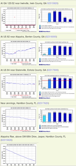 Update 2016-12-23: graphs from water.weather.gov.
Update 2016-05-31: See sea level gage reports.
Update 2015-04-28: Added flood stages and tentative highest safe and lowest boatable water levels, both above the charts for each gauge and in a summary table. If you have data, please let us know.
Here are water level gauges for the Alapaha River in Georgia and Florida, north to south. The graphs should show the current levels at this time, in feet, plus for most of the gauges a bar graph of selected historic levels.
This is a draft of a concept for use with the Alapaha River Water Trail. See also Alapaha River Rainy Season.
It is also a companion to the similar set of graphs for the Withlacoochee and Little Rivers.
See below for the current Alapaha River water level graphs. Continue reading
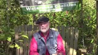 WWALS Ambassador Dave Hetzel explains the
Alapaha River Water Trail: recreation through fishing, swimming, boating,
conservation, and economic benefits through heads on beds, restaurant
customers, gas, and outfitters. Continue reading
WWALS Ambassador Dave Hetzel explains the
Alapaha River Water Trail: recreation through fishing, swimming, boating,
conservation, and economic benefits through heads on beds, restaurant
customers, gas, and outfitters. Continue reading
There’s are a reason the WWALS Mission says “conservation”. It’s pithily summed up by Prof. Rahul Mehrotra.
Elizabeth Gudrais wrote for Harvard Magazine May-June 2012, Engaging Students with Conservation,
PROFESSOR OF URBAN DESIGN and planning Rahul Mehrotra has been involved with restoring historic palaces, writing a law on historic preservation in Mumbai, and crafting a conservation master plan for the Taj Mahal. Harvard recruited him in part for this expertise, and this academic year, with Noyes professor in architectural theory Michael Hays, he has launched a conservation track for Graduate School of Design (GSD) master’s students.
Conservation, he says, is not the same as preservation, which focuses on protection and repair. Conservation is broader and richer, combining historical integrity and creativity to develop narratives connecting the present with the past.
Historical narratives like connecting Continue reading
 Lanier County Advocate, 2 Oct 2014:
The 2nd Annual Flatlanders Canoe and Kayak Race will be held at Lake Irma in Lakeland on Sunday, October 5, starting at 2:30 p.m.
There is no charge to participate in this event, and it will again feature the popular “If It Floats, It’s a Boat” race.
Rules for the canoe and kayak races include: Continue reading
Thanks to Glenn Dowling of Georgia River Network for this flyer from the 1970s for an Alapaha River Trail on “Georgia’s Cleanest River”.
Front
CANOE GUIDE
to the
Alapaha
River TrailGEORGIA’S CLEANEST
RIVERGEORGIA
State of AdventureBack
Continue reading
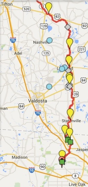
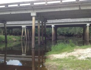
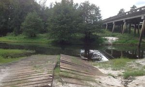 Pictures of the location of the
Alapaha River Cleanup at US 82, 27 September 2014,
taken east of the town of Alapaha at US 82 on the Alapaha River by Bret Wagenhorst.
Pictures of the location of the
Alapaha River Cleanup at US 82, 27 September 2014,
taken east of the town of Alapaha at US 82 on the Alapaha River by Bret Wagenhorst.
And this access point is on the Alapaha River Water Trail WWALS is developing.
Continue reading
 Second WWALS outing this month, this time on land;
facebook event.
Second WWALS outing this month, this time on land;
facebook event.
If you enjoy paddling the Alapaha River, I hope you will consider coming out this Saturday to give back and help clean up along the river’s banks as part of a
GA Rivers Alive cleanup. Starts at 0900 at the boat ramp at the Hwy 82 bridge just east of the town of Alapaha. I anticipate the cleanup will last about an hour. Bring work gloves and good cheer.
It is much easier to pick up trash along the banks Continue reading