
 “There currently are no plans for more development on Jekyll Island”
said JIA in a response to
WWALS’ assertion that marsh is not land.
So why does a map under consideration by JIA
show all marsh as land at mean high tide?
Could “currently” mean until the law gets changed? -jsq
“There currently are no plans for more development on Jekyll Island”
said JIA in a response to
WWALS’ assertion that marsh is not land.
So why does a map under consideration by JIA
show all marsh as land at mean high tide?
Could “currently” mean until the law gets changed? -jsq
Category Archives: Politics
JIA map shows all marsh as land at mean high tide –David Egan
 Received Thursday on
Marsh is not land, not here, not at Jekyll Island –WWALS Watershed Coalition -jsq
Received Thursday on
Marsh is not land, not here, not at Jekyll Island –WWALS Watershed Coalition -jsq
WWALS Watershed Coalition is on target with its analysis of the Jekyll 65-35 issue! Just a quick glance at the the 65-35 map under consideration by the JIA reveals all —- according to the JIA, ALL of Jekyll’s tidal marsh is above water, as in dry, at mean high tide, and is therefore part of the land area of Jekyll Islnsd subject to the 65-35 law. On-site conditions deny the accuracy of that map, for most of the marsh is actually under water (as in wet) at the time of high tide. The JIA’s map can be viewed at http://www.savejekyllisland.org/MPMOAAMHWPapJuly2013.html
-David Egan
SaveJekyllIsland.org wrote: Continue reading
Marsh is not land, not here, not at Jekyll Island –WWALS Watershed Coalition
Unanimously approved Wednesday by the WWALS board (PDF). JIA meets next Monday 15 July 2013.
From:
WWALS Watershed Coalition
3338 Country Club Road #L336
Valdosta, GA 31605
www.wwals.net
10 July 2013
To:
Governor Nathan Deal,
Attorney General Sam Olens,
the Jekyll Island Authority,
and the Georgia Legislature
Here in central south Georgia our pocosin swamps and blackwater river flood plains are important for fishing, hunting, wildlife and ecological preservation as well as recreation and flood control. In our watersheds we have serious problems of flooding at least partly due to Continue reading
Ask Georgia Power to conserve our water –WWALS to GA PSC
Approved 12 June 2013 by unanimous vote of the WWALS board, Dave has mailed a signed copy to the Georgia Public Service Commission, and I will go read it to the PSC Tuesday morning at 10 AM 18 June 2013, at their hearing about
Docket 36498, Georgia Power Company’s 2013 Integrated Resource Plan and Application for Decertification of Various Unitsand
Docket 36499, Application for the Certification of Amended Demand Side Management Plan
Y’all come! -jsq
From: WWALS Watershed Coalition, Inc.
3338 Country Club Road #L336
Valdosta, GA 31605
12 June 2013To: Georgia
Public Service Commission
244 Washington Street, SW
Atlanta GA, 30334-9052
Dear Public Service Commissioners and Staff,
The recent rains have swollen our blackwater rivers, Withlacoochee, Willacoochee, Alapaha, and Little, under our longleaf pines and Spanish-moss-covered oaks, and filled up the tea-colored tannin waters in our frog-singing pocosin cypress swamps here in central South Georgia. But that was only a dent in our protracted drought that ranges from mild to extreme, with projections not much better.

We do not need more traditional big baseload power plants gulping down our river or aquifer water when solar and wind power use far less, and those renewables are now at grid parity with coal, natural gas, and nuclear.
Power plants are thirsty, as the Union of Concerned Scientists pointed out in a 2011 report, “Freshwater Use by U.S. Power Plants: Electricity’s Thirst for a Precious Resource”.
Much of the water used to cool power plants evaporates, and is Continue reading
Blocked: Hotchkiss Landing closed by big blocks of concrete, October 2010
Why was a public road, Old State Road, blocked by concrete blocks from late 2010 through at least early 2012, right at Hotchkiss Landing on the Alapaha River in Lowndes County, Georgia?
According to two witnesses, this is what Old State Road at Hotchkiss Landing looked like shortly after the Lowndes County Commission decision of 26 October 2010 to keep the road open:
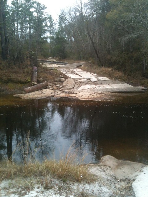
Picture by Cactus Clyde on flickr, who wrote:
“Alapaha River a mile upstream pf the US84 bridge (on the Hotchkiss Road) east of Naylor, GA- river level 77.96′ at Statenville, GA on 12/11/11. No acces on the west side any longer- this was taken looking west.”
April Huntley says “It happened right after the decision to not close the road.” Chris Graham says this was “Few days after we won.” According to the date on that picture, the road was still blocked 11 December 2011.
Google Earth shows that same blockage for 14 January 2012 in imagery taken by NASA, and that’s also what the current google map shows:
Continue readingOverwhelming majority of Americans want clean water and renewable energy –poll
 A
new poll
says 94% want new energy balanced with clean air and water, 86% want to shift from coal and nuclear to wind and water power, and 79% are concerned about shale gas fracking affecting water quality.
A
new poll
says 94% want new energy balanced with clean air and water, 86% want to shift from coal and nuclear to wind and water power, and 79% are concerned about shale gas fracking affecting water quality.
-jsq